When and how Tropical Storm Elsa will impact NJ
The Bottom Line
As I discussed on Tuesday, there are a lot of moving parts to this week's weather forecast: From heat, to thunderstorms, to Tropical Storm Elsa.
Tuesday's ferocious heat and humidity was followed by some incredibly intense thunderstorms.

To an extent, we'll do it again on Wednesday: Potentially dangerous heat, followed by storms.
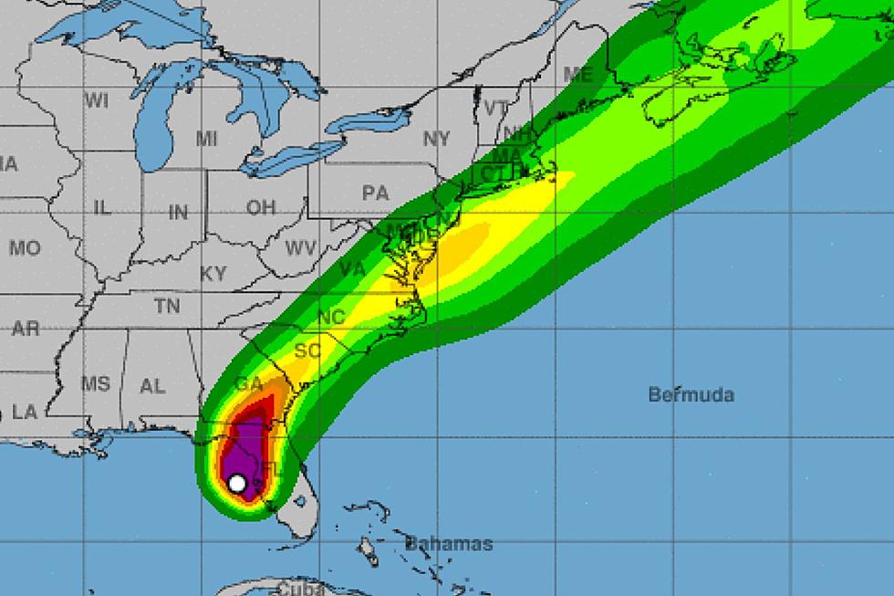
And then our attention turns to Tropical Storm Elsa, making landfall along Florida's Gulf Coast Wednesday morning. It will drive rain and wind toward New Jersey, and we're now getting a better sense of the overall timeline and impacts. I still maintain that it's going to be inclement, if not downright nasty, for a half-a-day. But not quite catastrophic here in New Jersey.
Another Day of Heat
High temperatures on Wednesday will once again surge to about 90 to 95 degrees, with lots of hazy sunshine overhead. (Beaches in the 80s.) Factor in the humidity, and the heat index could be in the 100 to 105 range during the hottest part of the day.
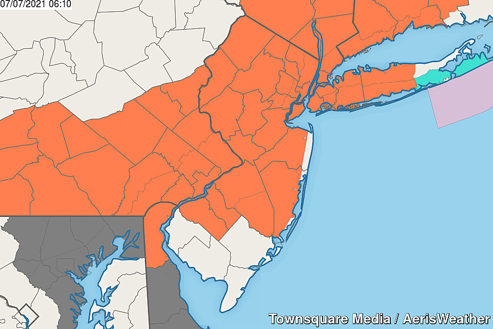
A Heat Advisory continues for most of the state through 8 p.m. Wednesday evening.
Another Round of Thunderstorms
The parameters for Wednesday evening do not look as "explosive" as they did for Tuesday evening. In fact, the chance for thunderstorms isn't even guaranteed - there are a few models that paint a dry solution for the Garden State.
I still think there's good reason to stay "weather aware" though, with plenty of energy (2000+ CAPE) and moisture (70+ dew points) to work with. Wind, rain, and lightning will once again be our primary concerns (in that order). Best timing for storms will be 6 p.m. to Midnight. Highest chance of thunderstorms will be northern and central New Jersey.
Elsa Timeline
Thursday will start quiet, with increasing clouds. It will be very warm, but not as hot, with highs in the mid 80s or so.
A few showers and thunderstorms may precede Elsa's actual arrival, Thursday afternoon.
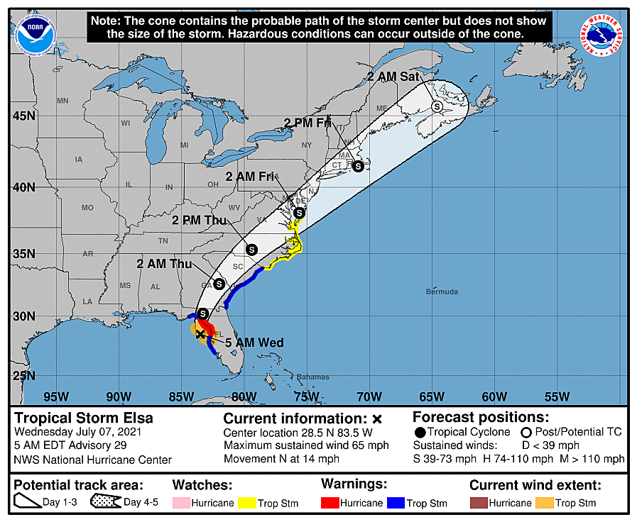
The storm itself will push into southwestern New Jersey Thursday evening, between about 5 p.m. and 9 p.m. The rain and wind will spread throughout the entire state by around Midnight Thursday night.
The worst weather conditions - the heaviest rain and strongest winds - will come overnight.
Conditions should largely improve by daybreak Friday. Having said that, rain and wind may linger through about midday Friday, before skies clear through the afternoon.
Elsa Weather Impacts
The latest model runs are somewhat more concerning for New Jersey, as the storm has taken a subtle jog to the west and north (closer to us). Let me lay out some best-case and worst-case scenarios here for specific weather impact categories.
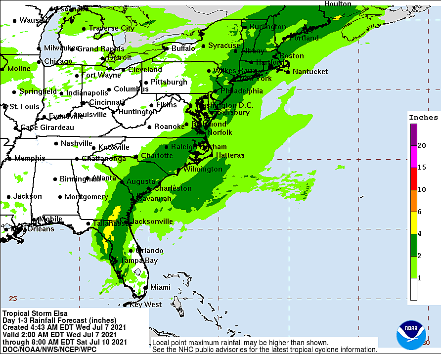
Rain... My usual mantra: Never underestimate tropical moisture. A solid half-inch of rainfall seems like a good bet for the entire state. If the most likely storm track plays out, 1 to 2 inches of heavy rain would fall along the coast. Some models do paint the potential for spotty areas of even heavier, more significant rainfall over New Jersey. If those tropical rain bands set up, 3 to 5 inch totals would be possible. That's enough to ring flash flooding alarm bells.
Wind... Even though tropical storms are measured and categorized by "maximum sustained winds," I prefer to look at top gusts. 30 mph wind gusts are pretty much guaranteed. 40 mph wind gusts are likely during the height of the storm, especially along the coast. And we'll have to keep the possibility for higher gusts in mind too - again, that's going to be very track-dependent.
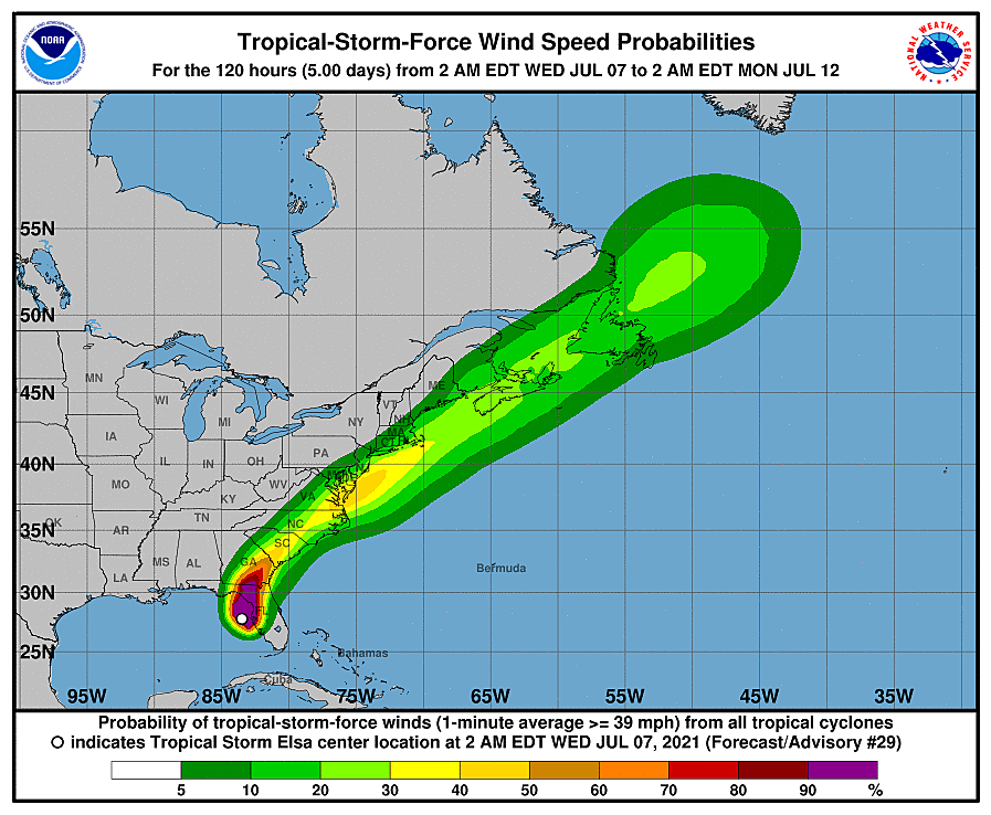
Severe Weather... The closer we get to the center of Elsa, the more "twisting" action will be present in the atmosphere. And, typical of tropical cyclones, that does raise the risk of tornadoes. I strongly believe the tornadic threat will stay primarily south of New Jersey. But again, quick spin-ups are not impossible here.
Elsa Coastal Impacts
While Elsa will likely be classified as a tropical storm as it ejects into the Atlantic Ocean, it's important to remember it's approaching us from the southwest. Much more of a "continental" storm system than a "marine" one. The track and orientation of the storm will not be conducive to coastal concerns, I'm happy to say.
Could we experience a period of rough surf? And maybe a half-foot of storm surge, causing very isolated flooding issues? Sure. But I'm confident that coastal impacts will be minimal.
The Extended Forecast
I don't want to dig too deeply into the weekend forecast, as it will ultimately depend on how Elsa plays out. (Chaos theory and "the butterfly effect" are very much in play in meteorology.)
At the moment, I favor a mainly dry and pleasant day Saturday, with highs in the lower 80s. The better chance for scattered rain will come on Sunday.
Dan Zarrow is Chief Meteorologist for Townsquare Media New Jersey. Follow him on Facebook or Twitter for the latest forecast and realtime weather updates.
Trending News Now
Gallery Credit: Trending News Now
More From 92.7 WOBM


