Weekend winter storm: Mainly sleet and freezing rain for NJ
Another weekend, another winter storm. I am very much looking forward to one week from now when our hyperactive weather pattern finally simmers down. Of course, between now and then, we have a series of concerning storm systems in the forecast.
The worst-case scenario isn't necessarily snow, but rather ice accumulations. The conditions that allow freezing rain to occur are very narrow. But ice storms are awful.

Friday: Quiet and Cold
No weather concerns for Friday. As expected, we did see some light snow barely kiss Cape May, N.J. overnight. And I wouldn't rule out a few flurries flying around later on. Otherwise, look for partly sunny skies and cold temperatures. Morning lows are mainly teens and 20s. And high temperatures look to only reach about 30 degrees. Most of the state will be stuck below freezing all day.
Friday night also looks quiet, although frigid. Clouds overhead, lows in the teens.
Saturday-Sunday: Icy Mix
We'll start the weekend with mostly cloudy skies. And those cold temperatures will prime the freezing cold ground for what's to come later in the day.
Frankly, our incoming storm system isn't very well-organized or strong. And it's going to pass pretty far to our south and east. So precipitation intensity won't be all that heavy. But when it comes to icy mix, it doesn't take much to make for a very slippery scene.
Because it's not a "monster" storm, the timing picture is somewhat hazy. I wouldn't rule out some morning showers. Then wintry mix will really fill in across the state in the Saturday afternoon and evening hours.
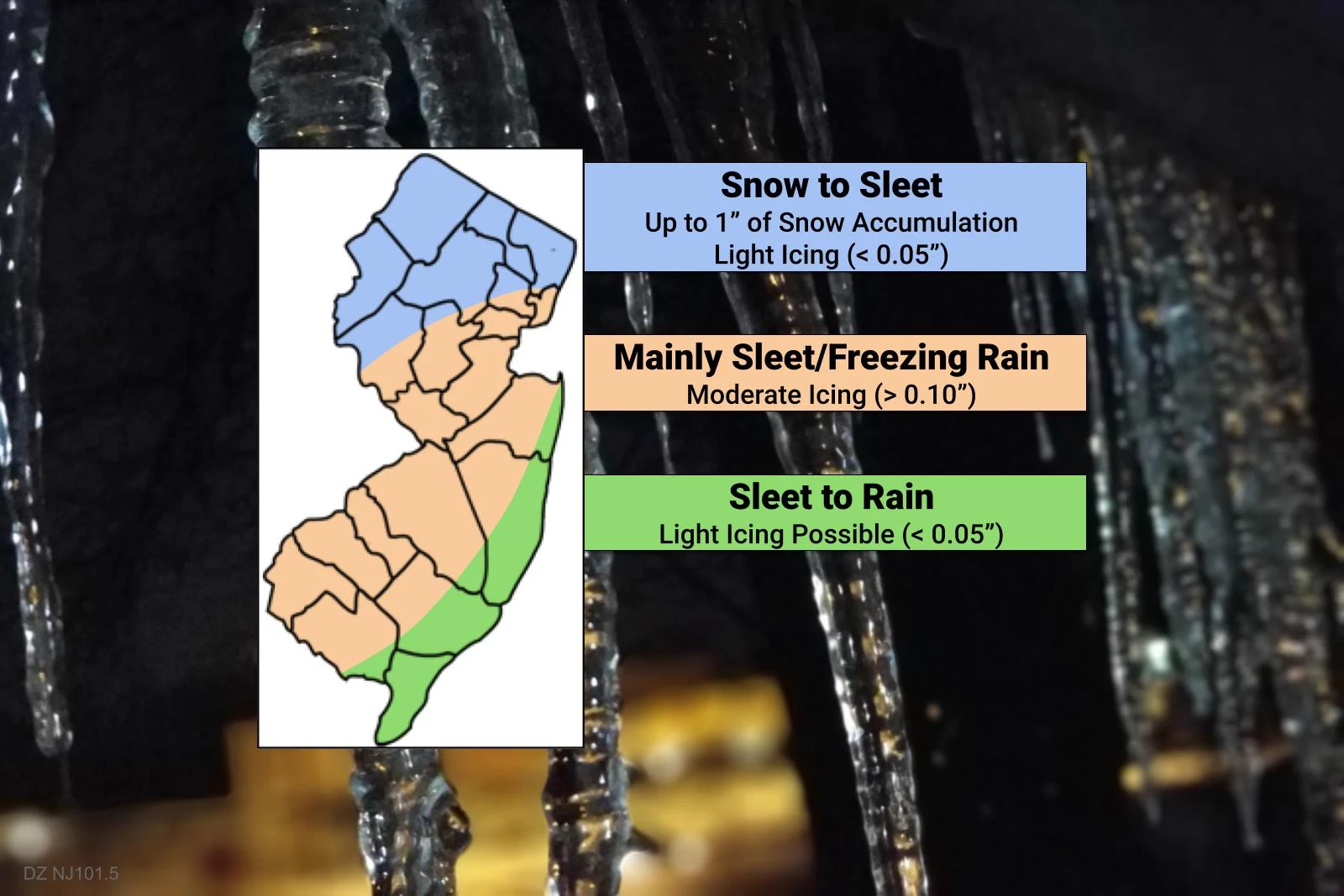
Initial precipitation type will probably be mainly snow north of I-78, mainly sleet along and west of the NJ Turnpike, and a mix of sleet and rain closer to the coast. That will eventually transition to sleet, sleet/freezing rain, plain rain, respectively.
The worst weather looks to come Saturday night through Sunday morning. No matter what's falling from the sky — snow, sleet, freezing rain, or rain — it's going to be rather unpleasant outside.
Best-case scenario? The ground ends up just warm enough to sustain wet, rather than icy conditions. Because the corridor of conditions that cause sleet and freezing rain is so narrow, it's a legitimate possibility.
Medium-case scenario? Up to a half-inch of snow accumulation in North Jersey. (That's literally all I expect to fall.) And then limited light icing on untreated surfaces, especially away from the coast.
Worst-case scenario? Most of the state gets light to moderate icing, on the order of a tenth of an inch to a quarter-inch of ice accumulation. Not only would conditions become very slippery, but that heavy ice would bring down trees and power lines.
I am hopeful that any icy mix tapers off Sunday morning, leading to a break in the nastiness into the afternoon hours. Don't expect any substantial breaks of sun though.
Monday-Tuesday: Maybe More Ice, Maybe More Snow
Forecast models have trended in a weird direction for the Monday-Tuesday time frame. We had been tracking a powerful coastal storm system for Tuesday. But that's now tracking farther much farther west than previous — putting NJ firmly on the warm side of the storm. And there's now a little precursor event showing up for Monday too, presenting another chance for light wintry mix.
I'll be blunt — I really don't have a good handle on what's going to happen on Tuesday. Previous model runs had painted 10+ inches of snow in North Jersey. But now they're keyed into substantial icing, on the order of a half-inch. (That is really heavy!)
But I don't buy the current solution. At all. I think it's prudent to wait until our weekend storm is wrapping up before talking about specific impacts from the next big storm. I think that'll be Sunday — we'll still have about 48 hours at that point to dial in details and make preparations, if necessary.
Thursday: The Grand Finale
This long streak of active weather should come to an end with one more storm system around Thursday of next week. Once again, our resolution of this storm is quite low at this point (6 days out). I'm pretty sure we'll have a storm system in the neighborhood. But whether it will produce heavy snow, light snow, heavy ice, light ice, heavy rain, light rain, or hardly anything is highly uncertain at this time.
This entire forecast is incredibly complicated, and sensitive to exact temperatures (both at the surface and aloft). I'd even say because of the multiple rounds of mixed-precipitation wintry-mix, it's one of the most complicated weeks of weather I've had to cover here in New Jersey.
We'll just have to take it one storm at a time, one day at a time. And I'm definitely looking forward to late next week, when our weather pattern hopefully quiets down!
What's Next?
I will likely have a brief update on the potential weekend ice storm sometime Friday afternoon. We'll focus on any watches or advisories that have been issued, and why the temperature profile of the atmosphere is so important here.
Another comprehensive weather blog with a "final" forecast for the weekend storm will be posted Saturday morning. And then, of course, we'll have continuous coverage on-air and online through the weekend too.
Dan Zarrow is Chief Meteorologist for Townsquare Media New Jersey. Follow him on Facebook or Twitter for the latest forecast and realtime weather updates.
The 6 best ice cream places in NJ
More From 92.7 WOBM


