Weekend starts cold, ends with a winter storm: 11 things to know
1.) The Deep Freeze
It's cold. And windy. A bitter, blustery combination. And Friday promises to be New Jersey's coldest day in about two years. While we won't break any records, temperatures will be 10-15 degrees below normal for late January.
Friday morning is starting with temperatures near 20, and many wind chills in the single digits. Thermometers will struggle to reach the mid 20s by Friday afternoon. Of course, with regular 30+ mph wind gusts, the wind chill will be no better than the teens.
Remember the wind chill is not only the "feels like" temperature, but also the "apparent" temperature. The human body, animals, cars, and infrastructure all strain under this kind of extreme cold and wind.
The Great Lakes lake-effect snow machine is fired up too. And we could see a few light snow showers or flurries drift into New Jersey throughout Friday too. Hardly worth mentioning, since they'll be very light and scattered, and our air is incredibly dry.
Thankfully, the wind will lighten up Friday night. Clear and frigid conditions continue, with low temperatures mainly between 10 and 15 degrees.

2.) Calmer Heads Prevail
We catch a breath of quiet weather on Saturday. It will be sunny and dry, with lighter winds than Friday. High temperatures will reach about the freezing mark, in the lower 30s.
3.) Snow's Slow Start
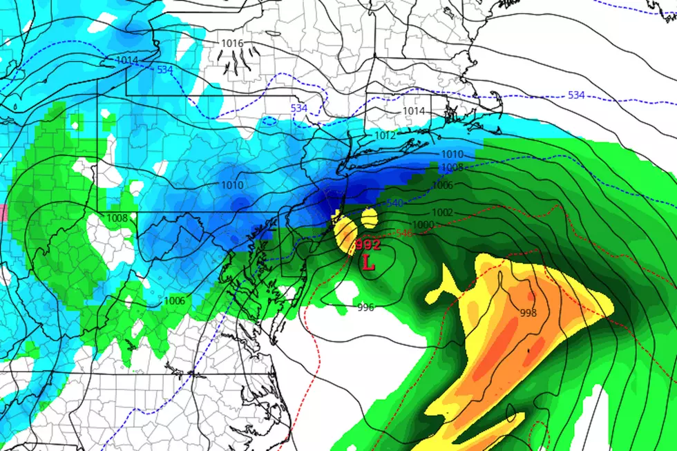
A storm system approaching from the west will be our next weathermaker. You can call it a nor'easter or coastal storm if you want.
On Thursday, I made the call that this storm would cause a wide variety of nasty conditions here in New Jersey. It's complicated. It will move very slowly. And it's still fair to call it high-impact, even though the accumulation picture is still really tricky.
We're now getting a clearer sense of how the storm's timeline will play out. And it's going to be a long-duration winter weather event, with 48+ hours of something falling from the sky.
Things will get started on Sunday, very very slowly. Light snow will bubble into southwestern New Jersey by Sunday afternoon, gently spreading northward and eastward as Sunday evening falls. Since the ground is so cold, the snow will start sticking immediately. And we could see about an inch or two on the ground within the first 12 hours. (In other words, not much, so far.)
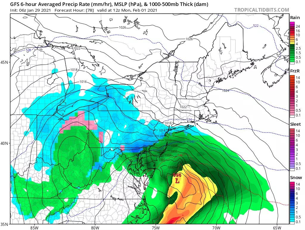
4.) The Brunt: Monday
Model consensus puts the heaviest precipitation over New Jersey during the daytime hours on Monday, from morning through afternoon. We'll call that the "peak" or "brunt" of the storm.
Worst-case scenario, snowfall rates in excess of an inch per hour would cause fast accumulations, low visibility, and rapidly deteriorating road conditions through much of the state. Honestly, it doesn't matter how much snow falls — those conditions are bad news in the middle of the work/school day.
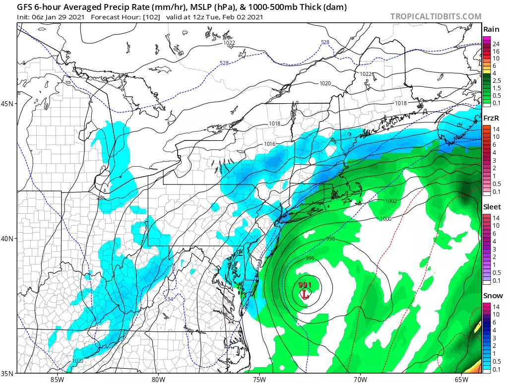
5.) Tuesday Tapering
A blocking area of high pressure to the north will keep the storm system complex nearby through much of Tuesday too. A slow tapering of snow/rain will progress approximately from west to east between Tuesday morning and Tuesday evening. But there will still be some bursts of heavier stuff, with additional light accumulations possible.
6.) It's Not All Snow
There is still a very good chance that some (if not much) of the storm's precip will transition to rain rather than snow, as northeast winds carry (relatively) warm air from the ocean toward the coast. The best chance for that changeover will be early Monday morning, as the winds and storm intensity begin to peak. As you'd expect, it's going to be difficult to maintain an "all snow" storm along the Jersey Shore. But exactly how that will impact accumulations is unclear, since that answer is very much track and temperature dependent.
I will say that any precipitation type transitions look "clean". In other words, the temperature profile of the atmosphere will either be favorable for either snow or rain, with little time spent in that murky "wintry mix" zone. For now, I'm keeping any mention of icing (due to sleet/freezing rain) out of the forecast.
7.) How Much? Don't Know.
Most (but not all) model solutions are still showing a significant hit of snow over New Jersey. And most (but not all) model solutions have drifted slightly south over the last day. It's not a notable trend yet. But, as we discussed previously, that would be a colder solution for New Jersey — leading to more snow rather than rain. It also would also push the snowfall bullseye closer to central or even southern New Jersey.
However, the snow total forecast will be especially sensitive to the exact storm track here. I believe almost any part of New Jersey could realistically see snowfall ranging from hardly anything to over a foot. (The only exception would be the southern coast, where temperatures may not be cold enough for an "all snow" or even "mainly snow" situation for the duration.)
Is it a "slam dunk" for significant snowfall? No way. There are a couple of "escape route" options for this storm to be a lesser deal than advertised. Namely, if the coastal low phases too far south or east (off-shore). Or if temperatures are far too warm for all snow. We'd still get some inclement weather, but it would not be a "blockbuster" storm. (At the moment, there are a few GFS/Euro ensemble members that paint such a scenario.) An "underperformer" is absolutely something to keep in the back of our minds for now.
You're going to start seeing forecasters issue concrete numbers and snow forecast maps Friday afternoon. (Some, already have. You might have better accuracy with a dartboard at this point.) I'll take a stab at drawing a map Saturday morning. Not before. That's still 48 hours from the peak of the storm, leaving plenty of time to adjust and tweak things before arrival. And plenty of time to plan and prepare, as needed.
8.) Nor'easterly Winds
Any powerful area of low pressure hugging the Atlantic coast will drive powerful winds through New Jersey. Latest guidance suggests gusts to 40 mph are possible, especially along the coast. That combined with falling (or fallen) snow could contribute to reduced visibility. Big gusts could make driving difficult, especially in high-profile vehicles. Bitter wind chills are practically certain. And snow-laden trees and power lines could be extra susceptible to wind damage too.
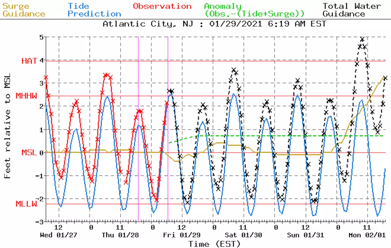
9.) Serious Coastal Flooding Concern
72-hour tidal guidance is now showing the possibility of 2 to 3 feet of storm surge along the Jersey Shore, starting with Monday morning's high tide cycle. That's pretty significant, enough to bring at least one or two cycles of at least moderate category flooding. Those in particularly vulnerable spots along the Jersey Shore — i.e. those whose streets flood during every strong nor'easter — should carefully consider travel plans and parking spots as the storm arrives.
We'll continue to revise the surge and tide forecast as the storm approaches. For Jersey Shore residents, this piece of the winter storm puzzle is going to be very, very important to monitor.
10.) Beyond the Storm
High pressure moves in Wednesday, leading to rapidly clearing skies and moderating temperatures (depending on snow cover). Another late-week storm system is currently forecast to bring warm air along with it, so it appears to be a rainmaker for now. (But hey, high temperatures popping to near 60 would be nice though, even if it's raining!)
11.) Coverage Plan
With a very dynamic and a potentially powerful winter storm in the forecast, you can count on us to stay on top of the nasty weather even though it arrives over the weekend.
My next weather blog post will be published by mid-morning Saturday. In it, I'll continue to refine the storm timeline, offer a much clearer pic of potential accumulations, and dig into the coastal flooding concern further.
That will most likely be followed by additional posts Saturday afternoon and Sunday morning (at least) with the latest.
And, as always, our entire news, digital, programming, and engineering team are ready to help you through the storm Sunday, Monday, and Tuesday, no matter what it brings to your neighborhood.
Dan Zarrow is Chief Meteorologist for Townsquare Media New Jersey. Follow him on Facebook or Twitter for the latest forecast and realtime weather updates.
Mornings On The Beach With Shawn & Sue
More From 92.7 WOBM


