
Tuesday NJ weather: The nicest, warmest day of the week
The Bottom Line
New Jersey's last 70-degree day was two weeks ago. On Tuesday, we will at least flirt with that magical temperature. That is 10+ degrees above normal for this time of year. I have no hesitation in calling Tuesday our warmest and therefore nicest day of this week.
Having said that, Wednesday and Thursday won't be half bad either. Then our next big storm system will soak the Garden State on Friday, followed by a blast of colder air for the weekend.

Tuesday
You will be reaching for a jacket once again Tuesday morning, with early temperatures averaging 40 degrees across the state. But come 8 or 9 a.m., thermometer will start jumping with the rising sun. And we'll top out in the upper 60s to around 70 degrees. Keep in mind, climatological normal highs for the 9th of November are between 57 and 59 degrees.
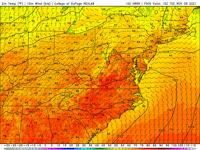
Mostly sunny skies. A light westerly breeze. Dry conditions. A beautiful day.
There will be some subtle changes in our weather later on, as a weak cold front approaches. Some clouds will start to build late Tuesday afternoon. The front is moisture-starved, but I will include a sprinkle chance in the forecast for early Wednesday morning. Meanwhile, the blanket of clouds will keep temperatures from crashing too far — we'll bottom out around 50 degrees, give or take.
Wednesday
In a new, cooler, drier air mass, Wednesday will be cooler than Tuesday. But only by a few degrees — it will still be a nice day.
A stiff northwesterly breeze may occasionally gust over 20 mph Wednesday morning, calming through the afternoon. Skies should flip back to sunshine quickly too. High temperatures should push into the lower to mid 60s — still notably above normal.
Thursday
Our next potential frost across inland New Jersey will come Thursday morning. (And even then, temperatures may be too warm in many spots, so I'll call it "patchy" frost.)
Skies will range from partly to mostly cloudy on Thursday. But we'll stay dry during the daytime hours. High temps will come down to the lower 60s or so. Again, still above seasonal averages.
Friday & Beyond
Our one and only "big" storm system of the week will roll in Friday. And it looks like New Jersey will get soaked, with periods of rain from early morning through afternoon. The steadiest, heaviest rain is still modeled to arrive during the Friday morning hours. Showers may linger through about dinnertime Friday evening.
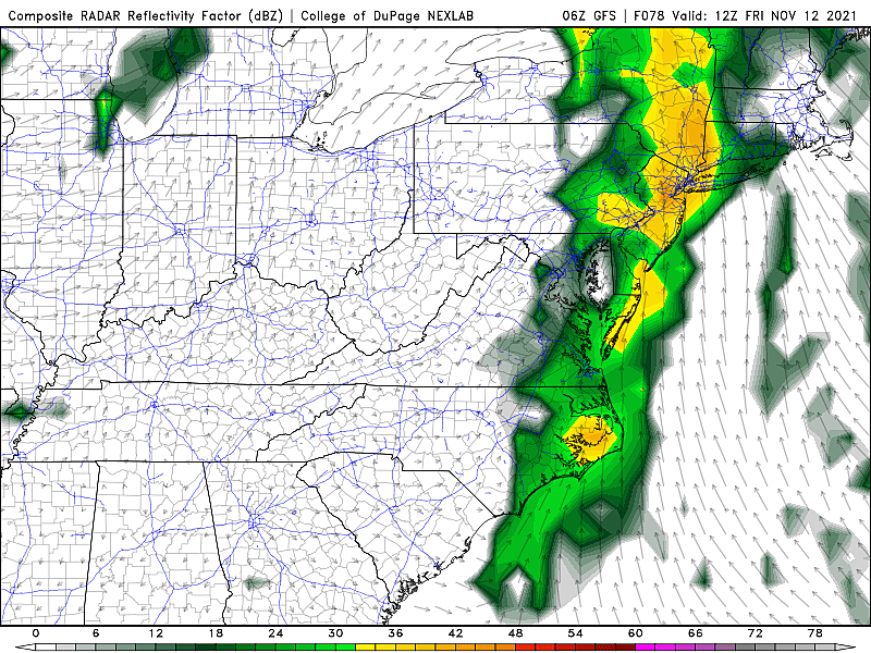
It is important to note that, with temperatures pushing into the 60s one more time, we're only talking about "wet" and not "wintry" weather here. Rainfall totals may exceed an inch in spots, but I do not anticipate any significant flooding issues. Rumbles of thunder are possible, although severe weather seems unlikely.
Beyond the rain, a much colder air mass will arrive for the weekend. So temperatures tumble Friday night, on a brisk westerly wind.
Saturday won't be terrible, as skies quickly clear to sunshine. But with a chilly breeze and high temperatures in the lower 50s or so, it will be a noticeable flip back to cold, blustery, more November-ish weather. (Note: That temperature forecast is somewhat uncertain — models show as warm as lower 60s or as cool as upper 40s at the moment.)
Temperatures will continue to descend on Sunday, potentially stuck below 50 degrees for much of the state.
In addition, both the GFS and Euro models have sporadically shown a compact shortwave sliding through New Jersey in the Sunday-Monday time frame. There are a lot of variables at play here. But, depending on the exact timing and exact temperatures, there is a chance for some snow activity (especially in North Jersey). However, it's far too early to talk about details about how far south snow could fall, whether it will accumulate, etc.
Dan Zarrow is Chief Meteorologist for Townsquare Media New Jersey. Follow him on Facebook or Twitter for the latest forecast and realtime weather updates.
How Firefighters training helped put out major fires
More From 92.7 WOBM


