
Saturday rain-snow-wind storm update for NJ: 9 things to know
UPDATE as of Noon Saturday...
The progression of rain to snow has been even slower than expected in South Jersey. Meanwhile, dry, sinking air has intruded earlier than expected. Our weather remains nasty and increasingly wintry, but the "brunt" of the storm with peak precipitation rates is over.
ORIGINAL POST from 7:21 a.m. Saturday...
1.) The Bottom Line
Here we go. Saturday could be New Jersey's last shot of significant accumulating snow of the season. This is a very dynamic, even violent, storm system that will bring rapid weather changes throughout the day. Rain to snow. Rumbles of thunder. Low visibility and poor travel conditions at times. Followed by bitter cold, biting wind chills, and a flash freeze Saturday night.
However, you'll find my final forecast is among the most conservative out there. Those who are buying into raw model output of 10" of snow have a very high bust potential here. (How many times has such underperformance happened so far this winter - three or four?)
For the record, my "final call" snow map uses the same contours and colors as the previous version. I have adjusted snowfall totals upward and timing earlier.
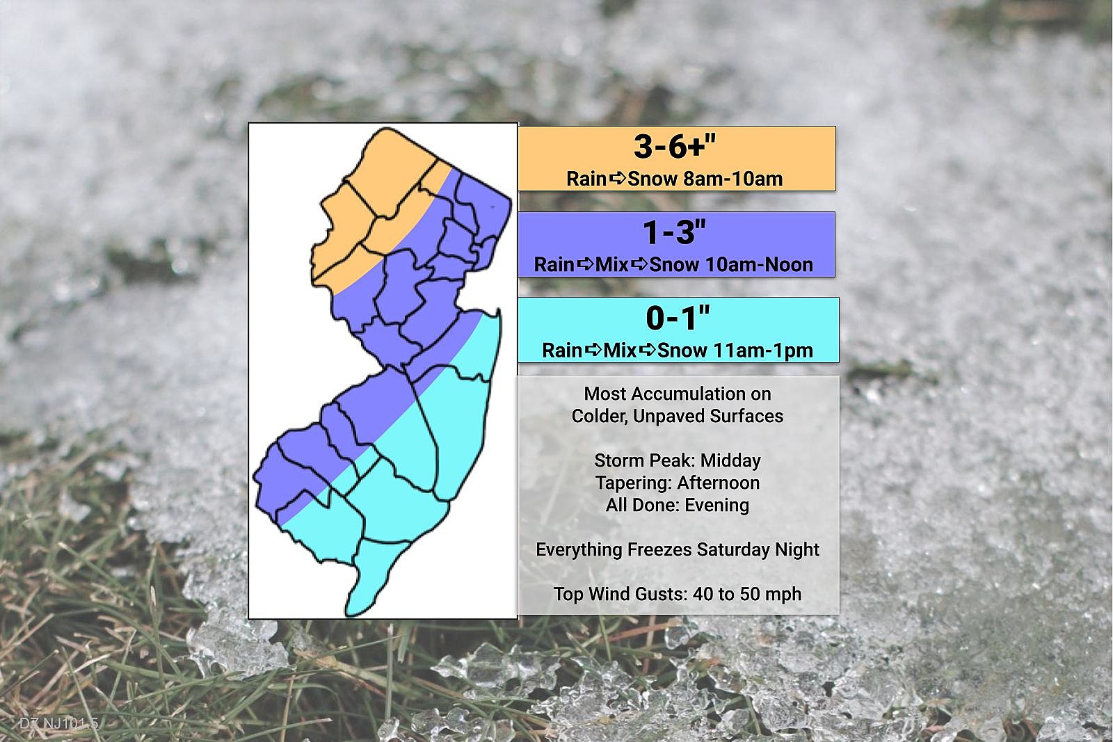
I have no doubt that snowfall will be heavy at times. But how much of that will stick, especially to warmer road surfaces? This is going to be a snowy day for northwestern New Jersey, where temperatures will be coldest and the storm's forcing will be the greatest. But the NJ Turnpike corridor may not cleanly flip to snow until the heavy stuff is wrapping up, limiting overall accumulations. And the Jersey Shore and South Jersey won't changeover until dry air comes into play, causing snowfall intensity to dial way back through the afternoon.
The bottom line: There will be periods of tricky travel on Saturday, especially due to low visibility and some traction concerns. Northwestern New Jersey will be reaching for the shovels and plows. For most of the state, it will be a wet, wintry, windy day - but not a crippling, blockbuster storm.

2.) Timeline
--Early Morning (before 8 a.m.)... Radar fills in, as storm system arrives from the southwest. With temperatures almost totally in the 40s across the state, it will start as plain rain. Some pockets of heavier rain are possible.
--Mid Morning (8 a.m. to 10 a.m.)... As temperatures start to crash in NW NJ, rain will flip to snow. It should be a pretty clean transition, with only a short period of mixing in-between. However, snow will only start to accumulate on the warm ground once reaching moderate to heavy intensity.
--Late Morning (10 a.m. to Noon)... The brunt of the storm. The freezing line will drift closer to the NJ Turnpike / I-95 corridor at this time. A period of rain-snow mix may occur at first, before changing to all snow. Meanwhile, as the storm system intensifies, the heaviest precipitation bands of the day will kick in, affecting mainly northern and western NJ.
--Early Afternoon (Noon to 2 p.m.)... Still the peak of the storm, in terms of intensity. Also, southern and coastal New Jersey should start to changeover to wintry mix then snow at this point.
--Afternoon to Early Evening (2 p.m. to 6 p.m.)... Eventually this afternoon, dry, sinking air will put an end to heavy snow bands. Accumulations will all but stop, but our weather will remain fairly wintry with scattered light to moderate snow across the state. Temperatures will continue to drop, with a gusty northwest wind.
--Night (after 6 p.m.)... Final flakes should fall over New Jersey right around sunset, and skies will clear Saturday evening. Temperatures will be in the 20s at that point, bottoming out in the teens overnight. Although the gustiest winds will subside, a healthy breeze will put wind chills in the single digits overnight. A flash freeze is likely, with all puddles and wet surfaces icing over overnight.
3.) Rain
Initial rain could be heavy in pockets, leading to ponding and minor flooding concerns in low-lying and poor-drainage issues. We could see up to an inch of rain total, especially to the south.
However, earlier concerns about "gusty thunderstorms" and "severe weather" have become minimal at this point. Given the earlier wet-to-wintry transition time, and cooler overall temperatures (40s instead of 50s), that threat should stay south of New Jersey.
4.) Snow
Here's the thing. It's going to snow. Everywhere in the state. But how much of that sticks depends on the timing and speed of the transition, and the intensity of the snowfall.
As my "final call" snowfall map shows, I do expect at least moderate snow accumulations throughout the northwest corner of New Jersey Saturday, on the order of 3 to 6 inches. Definitely shovelable, probably plowable. If we get more than one heavy snow band to visit that area, I could see some spots could reach as high as 7 or 8 inches. (Hence the "plus".)
The middle of the state - on either side of the NJ Turnpike - is a much tougher call. In the end, I settled on 1 to 3 inches, using my usual mindset of "equal chances of busting high or low". If a heavier snow band does set up in Central New Jersey, leading to inch-an-hour snowfall, it's going to accumulate quickly. However, if it doesn't, and we get dry slotted, there may be very little accumulation. Remember, it's not just about how much snow "falls" from the sky, I have to look at how much "sticks" to the ground. This is the least certain and most dynamic piece of this forecast puzzle.
Finally, some snow accumulation is possible to the south and east. Possibly up to an inch on grass. But don't expect much - the heaviest snow bands will stay away, and the moisture faucet will turn off before you have time to see much accumulate.
5.) Wind
Yeah, the wind is going to blow. (Literally and metaphorically.)
Given the latest storm track, I don't think the early morning southerly return flow is going to be that strong. (As of this writing, around 7 a.m., winds are practically calm.)
However, once the cold front arrives and colder air starts flowing, that wind will get quite gusty. Most models max out around 40 mph. A period of heavy precipitation could cause even stronger winds to mix down to the surface, potentially near 50 mph.
Those fierce winds could result in even lower visibility and near-blizzard conditions. Power outages, downed trees, and driving difficulties are also concerns.
Winds should slowly subside Saturday night. But it's still going to be blustery and breezy (at least) through Sunday morning.
6.) Cold
Thermometers will tumble from the 40s Saturday morning, to the 20s by sunset, into the teens by early Sunday morning. That may be typical in the dead of winter, in mid-January. But here in mid-March, that is quite cold. Those low temperatures will run about 15 degrees below normal. I don't think we're going to set record lows, but it will be close.
As the wind continues to blow Saturday night, the wind chill ("feels like" or "apparent" temperature) will likely dip into the single digits. The cold is going to bite.
In addition, a "flash freeze" is likely. It's going to get so cold overnight that any and all puddles and wet surfaces will turn to ice. That could lead to a very slippery scene across the state Sunday morning.
Sunday's high temperatures will be limited to the mid 30s. That is again about 15 degrees below normal for this time of year.
7.) NO Coastal Flooding
Sometimes, a storm of this magnitude and at this time of year can cause significant flooding of tidal waterways along the Jersey Shore.
However, this is not a classic coastal storm (nor'easter). It will undergo rapid intensification, getting the ocean all churned up. But the tide should not rise more than a foot, keeping water levels below flood stage.
In fact, with the strong northwesterly winds following the cold frontal passage, I'm more concerned about a very low ("blowout") tide late Saturday into early Sunday.
8.) Advisories
A Winter Storm Warning continues for Sussex and Warren counties only until 7 p.m. Saturday. That's the snow bullseye, where concerns for treacherous travel are greatest.
A less-severe Winter Weather Advisory covers the middle portion of the state, especially along and northwest of the NJ Turnpike. Minor to moderate impacts are expected here, due to reduced visibility and icy roads. The advisory covers the following counties, for the following time periods...
--8 a.m. to 7 p.m... Western Bergen, Hunterdon, Mercer, Middlesex, Morris, Somerset, and western Passaic.
--9 a.m. to 7 p.m... Eastern Bergen, Essex, Hudson, eastern Passaic, and Union.
--10 a.m. to 7 p.m... Northwestern Burlington, Camden, Gloucester, and Salem.
There are no "wintry" alerts for southern or coastal New Jersey at this time.
A Wind Advisory is posted for the entire state, cautioning of that 50 mph gust potential. It runs from Saturday late morning through Sunday early morning.
9.) What's Next?
After a messy Saturday and a cold Sunday, our weather calms down and evens out through the final week of winter.
A snow shower or squall is possible Sunday afternoon.
Monday morning will be a freeze for most of the state, so watch for icy spots again. But temperatures will moderate nicely Monday afternoon, reaching the 50s away from the coast.
We'll make a run for 60 on Tuesday, another nice day.
And temperatures will remain above normal through the second half of next week. That means the few weak impulses riding through New Jersey would produce rain showers, nothing wintry.
In fact, I don't see any significant winter storms on the horizon, for the next 7 to 10 days at least. Although I'm not quite ready to "bang the gavel" on snow season, we're getting close.
Dan Zarrow is Chief Meteorologist for Townsquare Media New Jersey. Follow him on Facebook or Twitter for the latest forecast and realtime weather updates.
BEEP BEEP BEEP: These are the 13 types of Wireless Emergency Alerts auto-pushed to your phone
Gallery Credit: Dan Zarrow
School aid for all New Jersey districts for 2022-23
Gallery Credit: Michael Symons
More From 92.7 WOBM


