
Rain, flooding, and some snow: Two coastal storms aiming for NJ
Oh boy, it's going to be a busy week here in the weather center. Not one but two coastal storm systems are in the forecast, and parts of the state could experience the first snowflakes of the season. Let's dive right in!
Overture: Monday
The new week begins with a cold start. Temperatures have fallen into the 20s across the vast majority of New Jersey. Only the immediate coast will escape a freeze Monday morning. Don't be surprised if you catch a few flurries flying around too.
Skies will become mostly cloudy or overcast by midday Monday. Otherwise, it will be a quiet weather day — cool, with light winds. High temperatures will peak around 50 degrees, slightly warmer than the weekend.
Coastal Storm #1:Monday Night-Tuesday
--Bottom Line: A quick hit of mostly rain will make for a generally wet overnight and morning.
--Timing: Raindrops arrive in South Jersey Monday evening, spreading north through the rest of the state by about Midnight. Rain will exit the Garden State by midday Tuesday.
--Rain: A half-inch to an inch of rain is expected for most of New Jersey.
--Coastal Flooding: Minimal.
--Winter Weather: Cold air will be limited, so most precipitation should remain liquid. Having said that, I do believe a bit of sleet and/or snow will be possible at elevation in NW NJ. While little to no accumulation is expected, slippery roads and reduced visibility will be possible.
--Confidence: Moderate to high. Sure it might be messy during much of the overnight and for Tuesday morning's commute. But big, dramatic weather problems are not expected.
Intermission: Tuesday-Wednesday
After raindrops wrap up Tuesday, we'll keep mostly cloudy skies. A brisk wind (gusts to 30 mph) will eventually carry in colder air again. After we reach a high temperature in the almost-seasonable mid 50s Tuesday afternoon, thermometers will start to plummet Tuesday night.
Wednesday will be significantly colder, with high temperatures barely to 40 degrees. We'll see a mix of sun and clouds, with lighter winds and dry weather all day.
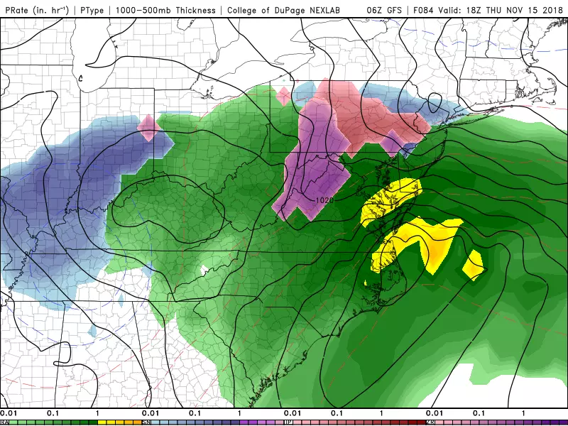
Coastal Storm #2: Thursday-Friday Morning
--Bottom Line: Clearly the more impactful storm system of the week. But uncertainty is high, specifically regarding the storm's timing — that will have a direct impact on how inclement and hazardous the weather gets in New Jersey. Rain is likely, wintry mix is possible, and we'll have to watch for minor to moderate coastal flooding as well.
--Timing: As it stands currently, the system arrives Thursday morning. At onset, there could be a period of wintry mix (snow, sleet, freezing rain) in central and northern New Jersey. As the storm carries warmer air into New Jersey, anything wintry should transition to wet by Thursday afternoon. Precipitation may linger into part of Friday morning.
--Rain: Rainfall totals may exceed an inch in some places. Periods of heavy rain may cause flooding.
--Coastal Flooding: We only have resolution on surge and tides about 72 hours / 3 days out. I am concerned about east-northeast winds driving ocean water toward the coast on Thursday. For now, I'll say a foot or two of surge could produce minor to moderate levels of tidal flooding. But if you live along the Jersey Shore, let's continue to watch this picture very closely.
--Wintry Weather: Could this be our first snowflakes and/or sleet pellets of the season? Quite possible — away from the coast, at least. As I mentioned, the best chance for wintry mix will be in central and northern New Jersey at this storm's onset. Models suggest light snow/ice accumulations in far North Jersey only (i.e. Sussex County). Even so, slippery roads and reduced visibility will be possible for a time.
--Confidence: Low. The forecast has shifted dramatically over the past day, and I highly doubt models have a firm handle on the forecast details just yet. We'll have better answers regarding this system starting Tuesday afternoon (after Storm #1 has passed).
Curtain Call: Weekend
After showers taper off Friday morning, we'll finally see the sun again by Friday afternoon. High temperatures should recover to about the 50 degree mark. Right now, I'm not seeing a period of ferocious winds, which means Friday could turn into a reasonably pleasant day.
The long-range forecast for the weekend also looks good for now. Look for mostly sunny skies and a stiff breeze, perhaps interrupted by a brief snow/rain shower. High temperatures are forecast to reach the upper 40s on Saturday and the lower 40s on Sunday.
More From 92.7 WOBM


