
NJ weather steps downhill as Florence’s remnants approach
What. A. Weekend! Holy cow, did we deserve that sunshine, warmth, and low humidity after a summer of intense heat, humidity, and constant rain. Now it's back to work and school, and back to reality as our weather takes a brief trip downhill again. Clouds and rain associated with Florence are expected over the next 36 to 48 hours. (Although — spoiler alert — after a little Florence hiccup, the rest of the week looks great!)
As of 5 a.m. Monday, Tropical Depression Florence was centered over southwestern Virginia. That means the Carolinas will finally get a break from the tropical rainfall as the storm traverses the Ohio Valley. As we discussed last week, Florence's remnants are swinging a big U-turn and will head toward the Northeast.
Keep in mind, Florence's remnant low is a mere shadow of its "major hurricane" former self. It's wide — the rain field is about 500 miles from end to end, stretching from Indiana to North Carolina. And it's wet — there's still plenty of moisture locked up in the atmosphere.
Monday unfortunately won't be as beautiful as the weekend, as mostly cloudy skies have taken over the Garden State. I think it's fair to quantify the day as "mostly dry," although we'll see isolated showers and sprinkles dot the state by midday. More substantial scattered showers will arrive Monday afternoon and evening. Because of the clouds and the rain threat, Monday's temperatures will be slightly cooler than Sunday, with highs around 80 degrees.
Obviously not a great weather day for the beach. But it's still important to note a Moderate Risk of dangerous rip currents has been posted again for the entire Jersey Shore.
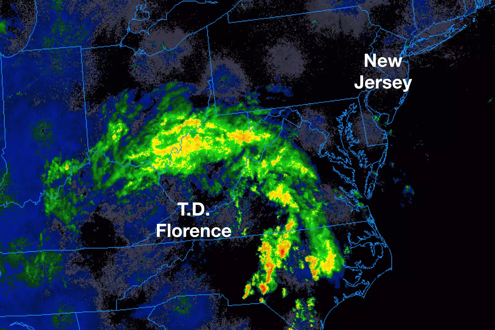
6 a.m. radar image, showing Florence's wide swath of rain stretching from Indiana to North Carolina. (College of DuPage Meteorology)[/caption]
Tuesday will be a wet day thanks to Florence, although I'll stop short at calling it a complete washout. The first half of the day will feature periods of rain, ranging from widespread light stuff to heavier downpours. The heaviest rain of the day is expected Tuesday late afternoon and early evening, as stronger thunderstorms potentially dump heavy rain on top of us.
The bulk of Florence's remnant rainfall looks to pass well west and north of New Jersey. I still think rainfall totals here will fall between a half-inch and an inch, with the possibility of 2 inches where it really pours. While flash flooding is possible from heavy rain, I don't think it's going to be a dramatic, widespread problem.
By Wednesday, we'll dry out nicely and kick into another stretch of pleasant weather. As skies clear to partly sunny, high temperatures will end up in the mid to upper 70s. That's pretty close to normal for late summer-early fall.
The dry weather continues for Thursday. Again, we'll enjoy partial sunshine with highs in the lower to mid 70s.
As winds pick up a bit and become southwesterly on Friday, thermometers will warm up into the 80s once again. It will still be a nice, dry, mostly sunny day.
Saturday will be our next "cold front day". While previous models had painted a pretty wet afternoon, this morning's model suite has dried out the forecast considerably. Whether Saturday turns out wet or dry, Sunday looks to be the cooler day of the weekend.
Autumn officially "falls" this Saturday at 9:54 p.m. EDT. And right on time, I'm starting to see evidence of "the roller coaster of fall" developing by next weekend. You see, our descent from summer to winter isn't a sudden or gradual drop from the 90s right to the 30s. Instead, each successive cold front (about once a week) will knock back temperatures a little bit each time. So 90s turn to 80s, turn to 70s, turn to 60s, turn to 50s, etc. Ready or not, here come the cooler temperatures!
Dan Zarrow is Chief Meteorologist for Townsquare Media New Jersey. Follow him on Facebook or Twitter for the latest forecast and realtime weather updates.
More From 92.7 WOBM


