
NJ weather: Blast of cold air sets the stage for weekend snow
Hello! It's great to be back on the weather blog with you, albeit only for now. Before my departure for paternity leave, I set the guideline that any "advisory" level winter weather event would spark my return. So here we are, with wintry weather in the forecast. And here I am, with the latest thinking about this weekend's snow chance.
The Bottom Line
Let me break this forecast down into five simple bullet points for you:
1.) First step is a big cool down. Thursday's gusty wind (40+ mph) is ushering in arctic air. Look for temperatures to really bottom out on Friday, with the thermometer stuck below-freezing all day.
2.) The time frame for our next storm system is Saturday midday through late Saturday evening.
3.) Everyone in New Jersey will likely see snow at onset, through Saturday afternoon.
4.) However, as warmer air bubbles up from the south, a transition from snow to sleet to rain will kick in Saturday evening.
5.) Because it's a compact, fast-moving storm, with rising temperatures, snow accumulations will be limited. Yes, there will be slippery spots and hazardous travel conditions for a short time. But it's not a blizzard or major winter storm — no bread and milk shopping trip needed this time around.
Timeline
—The Beginning... As our storm system arrives from the west Saturday, we'll see first snowflakes fall between about 10 a.m. and 2 p.m. Initial precipitation should be snow for most of New Jersey, with temperatures generally in the lower 30s. Southern and coastal New Jersey may already be warm enough for more of a slushy mix than straight snowfall.
—The Peak... Heaviest precipitation will fall Saturday afternoon through early evening. Depending on when and where heavier snow bands set up, there could be visibility issues and slippery spots galore. Not a school day and not a work day, so travel impacts won't be quite as severe as they could be. But still, it could get pretty sloppy on the roads for a few hours.

—The Transition... South-southwesterly winds (both at the surface and a mile up in the atmosphere) will push warmer air into New Jersey, causing temperatures to rise Saturday evening. That means we'll see a changeover from snow to sleet (briefly) and then rain, progressing from south to north. That flip from wintry to wet will put a fast end to any accumulations.
—The End... Steady stuff should exit the Garden State by about 10 p.m. Saturday evening. Residual showers (mainly rain) will remain possible through early Sunday morning.
Totals
So how much snow will accumulate on the ground? Ahh, the all-important question. And, as always, there's no easy answer here. Especially since temperatures and snow intensity will be vastly different at opposite ends of the state.
When this storm first came on the radar early in the week, New Jersey looked prime for a half-foot of snow. However, as the track and temperature forecast evolved, that likelihood has faded. For the past day or two, I've been favoring about 3 inches of total snowfall for NW NJ, which will hold onto snow (rather than rain) for the longest period of time. That "advisory level" snow is the general magnitude I decided to stick with.
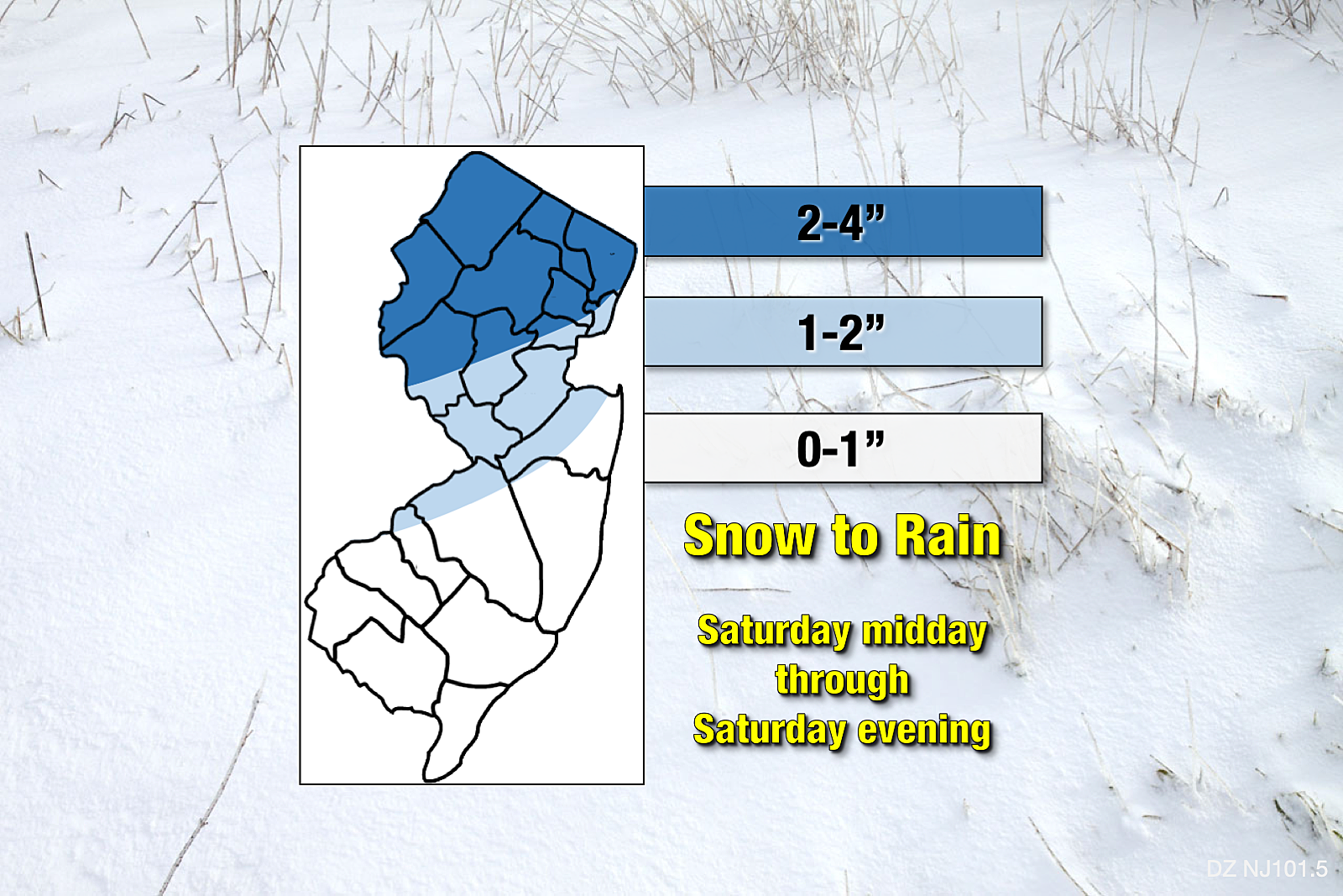
Is there a chance we see upwards of 6 inches of snow accumulation in North Jersey? Sure — all it would take is a heavy snow band getting stuck for an hour or two.
Could we see all rain along the Jersey Shore? Yup — as I mentioned above, temperatures will be very close to the freezing mark throughout Saturday afternoon.
If we see 2+ inches of snow reported somewhere in New Jersey, this would be only our 3rd official "snow event" of the 2019-20 winter season.
Confidence
No forecast is complete without a measure of forecast confidence — how certain I am that this prediction will play out.
In this case, I think we're in the "moderate" confidence zone. Model consensus is pretty good regarding timing — that includes the start, the peak, the transitions nd the end.
Snow totals are still a bit of a coin flip, as they'll be largely influenced by 1.) the placement of any bands of heavier snow, and 2.) the speed of the snow-rain transition. Raw model output of snowfall is still all over the place. The NAM is a bit lower than my forecast. (That's actually a bit surprising, as the NAM usually catches on to heavier mesoscale snow bands. Probably due to sleet/ice.) The GFS pushes 2+ inch snow farther into SW NJ. (Not out of the question.) The Euro is pretty close to the map I posted above. (It has held a very consistent solution over the past few runs.)
In Conclusion
So that's that. Not a blizzard. Not a nor'easter. Not a major winter storm. But our first chance of accumulating snow in 2020. And a definite end to our recent streak of mild temperatures.
As of this writing, we're still about 48 hours away from first flakes. Close enough to where I can provide some detail. But still plenty of time for things to shift and evolve.
I'll take two more stabs at nailing down the snow forecast here in the weather blog: 1.) Friday morning, and 2.) Saturday morning. And our entire weather, news, and traffic teams will continue to keep you updated on-air before, during, and after the storm.
Until then, I'll leave you with a photo of my week-old son Nathan... Who is looking forward to seeing his first snowflakes ever... And is probably ready for a bottle and a diaper change soon too...

Dan Zarrow is Chief Meteorologist for Townsquare Media New Jersey. Follow him on Facebook or Twitter for the latest forecast and realtime weather updates.

More From 92.7 WOBM


