NJ weather: Back to work with 1+ inch rain, 40+ mph wind, and coastal flooding
Why?
Sunday looks great! Mostly sunny and mild, with highs in the mid 50s. Can't ask for much more than that in late November.
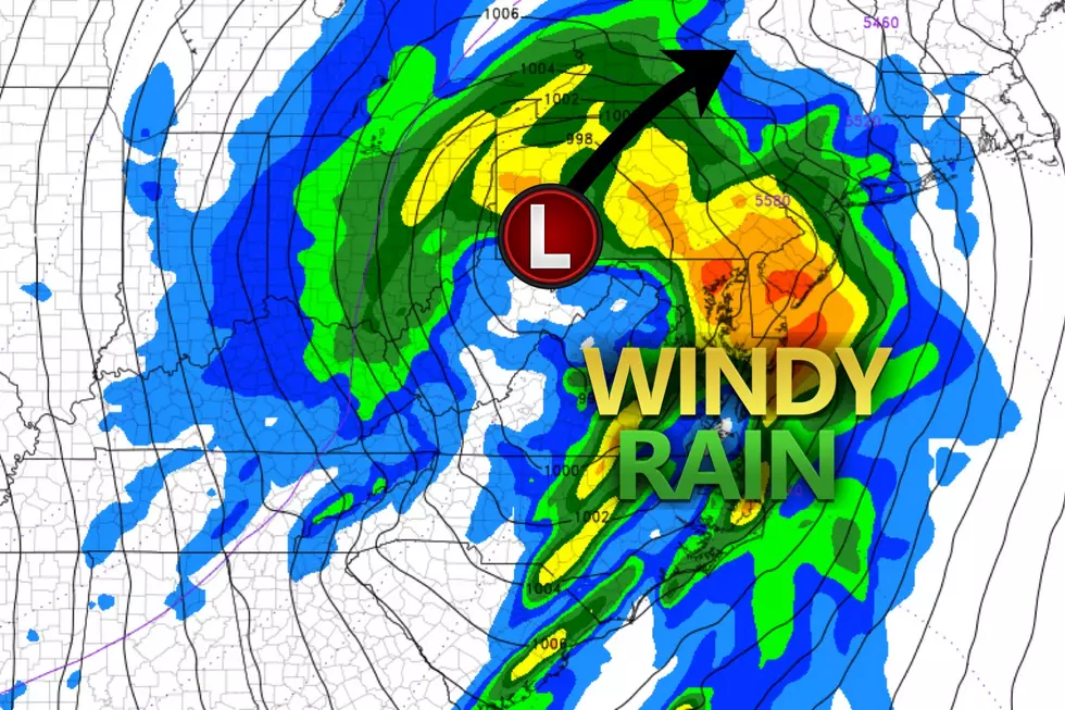
However, a powerful storm system is forecast to track through western Pennsylvania on Monday morning. For over a week, models have been consistently painting a wet and windy picture for New Jersey, on the eastern edge of the storm. (Of course, Ohio, on the colder western side of this storm system faces up to a half-foot of snow!)
The bottom line: Monday's forecast calls for a pretty nasty return to work and school after the Thanksgiving holiday weekend.

What?
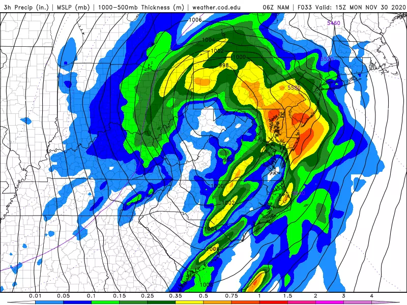
—Pockets of moderate to heavy rain will total about 0.50" to 1.50" by the end of Monday.
—South-southeast wind gusts expected to reach 40 mph inland and 50 mph coast.
—Minor to localized moderate coastal flooding seems likely, with 1 to 2 feet of storm surge.
—The risk of thunderstorms and severe weather is not zero — this may include thunderstorm-related wind and even an isolated tornado.
—No snow and ice are expected in New Jersey from this storm.
When?
—First raindrops will push across the Delaware River into western New Jersey just before sunrise Monday morning (4 a.m.)
—By mid-morning Monday (8 a.m.), it will be raining just about everywhere in the state.
—Heaviest, steadiest rain will fall from about mid-morning through early afternoon (8 a.m. to 1 p.m.) This will also be the period of peak wind and biggest tidal flooding risk.
—Scattered rain showers may last through Monday evening.
—As the storm system tracks into Canada, some rain and snow showers will be possible during the day Tuesday, mainly in northern New Jersey.
Who/Where?
Everyone in New Jersey is going to get wet. The heaviest rain will be found closest to the center of the storm system, along the western border of NJ. More specifically, model guidance puts 1-2" rainfall in NW NJ. Meanwhile, the southern coast will likely be limited to a more reasonable 0.5-1" throughout the day.
It's going to get windy everywhere too. Because of the low friction encountered over the ocean, the strongest 50 mph gusts will blow along the Jersey Shore. (That will be a mainly on-shore wind, by the way.) Further inland, gusts will reach about 40 mph — still pretty ferocious.
Painting an accurate coastal flooding picture is a bit trickier, as the strongest wind will have a definite southerly component to it. Therefore, I suspect the largest water rise will be found along coastlines with a southern exposure — along the Delaware Bay and River, Cape May and Atlantic counties, and back bays farther north. Tidal guidance shows a solid foot of water rise, leading to minor category flooding. Monday morning's high tide could approach moderate flood stage — that will be around 7 a.m. on the oceanfront, and several hours later for back bays and tributaries. High water levels are likely for Monday evening's and Tuesday morning's high tide cycles too (especially if the bays don't have an opportunity to fully drain after Monday morning's wind-driven water rise.)
So What?
My job as a meteorologist is to tell you what the weather's going to do. And I'm telling you that Monday is going to be a wet and windy, yucky, nasty day. That's it! Now, there are a few other things that make this forecast somewhat concerning — but not catastrophic by any means.
Rain is good. It waters the flowers and fills our reservoirs. However, visibility and traction will be reduced for much of Monday. And, of course, a lot of rain in a short period of time can lead to serious flooding issues. In this case, poor drainage areas will be susceptible to flash flooding during and just after the heaviest rain Monday morning/afternoon. That may lead to further travel difficulties.
40+ mph wind gusts are enough to blow down vulnerable trees and branches. Those can block roads. They could cause property damage. And/or fall on power lines, leading to sporadic outages.
And those who live along tidal waterways know the impacts and dangers of coastal flooding. We'll likely see water inundation in "the usual spots" — barrier islands, low-lying areas along routes 35 and 36, etc. But that Monday morning high tide cycle may go a little beyond that, perhaps reaching the moderate flooding category. That means more streets will see water, necessitating closure. (Along the lines of a strong nor'easter, perhaps.)
Know the weather. Plan ahead. Use common sense. You'll be fine. Period, full stop.
How Could Things Change?
No weather forecast is complete without a measure of the confidence we have in that particular solution. In other words, we have to consider how a storm system might "wiggle" or change, and what effect that would have on our anticipated sky and surf impacts.
In this case, I could see two possible things happening.
First, if the center of the low (storm system) tracks farther west than expected, New Jersey will end up even more on the eastern edge of the storm. The result would be lower rainfall and top wind gusts — although it would still be a wet and windy day overall.
Second, the speed of the storm is critical to the timing of our impacts. Forecast models have been pretty locked-in to Monday morning being the "brunt" of the storm here in the Garden State. However, if the storm moves faster than forecast, we'll clear away from the rain around lunchtime. On the other hand, if the storm slows down, there could be raindrops around through Monday evening.
What's Next?
Behind this powerful storm system, cooler air will settle over New Jersey through the rest of the week. We're back into frost/freeze territory on Wednesday/Thursday mornings, with highs only in the 40s those days. Seasonable 50s return by the end of the week.
But we're also watching our next storm system on the horizon, set to arrive in the Fri-Sat-Sun time frame. Right now, it looks like another rain-maker. But as the calendar turns to December, we're always watching for any frozen precipitation potential.
Dan Zarrow is Chief Meteorologist for Townsquare Media New Jersey. Follow him on Facebook or Twitter for the latest forecast and realtime weather updates.
The 10 Best Sunrises in Seaside Park
More From 92.7 WOBM


