
NJ turns unsettled again: Scattered thunderstorms Wednesday
The Bottom Line
I am absolutely loving the weather forecast this week. Spectacular warm, sunny days (like Tuesday) alternate with much-needed rainy days (like Wednesday). This is what mid-June is supposed to be about. Hopefully the "occasionally unsettled" weather pattern continues — every raindrop we get helps our parched crops, lawns, and reservoirs.
Wednesday's thunderstorm chance is "midday" rather than the traditional "late-day" timeline. There could be some stronger storm cells with gusty winds and downpours to watch out for.
Thursday will be beautiful again. Friday will be stormy again. And the bulk of the Father's Day Weekend forecast looks OK.

Wednesday
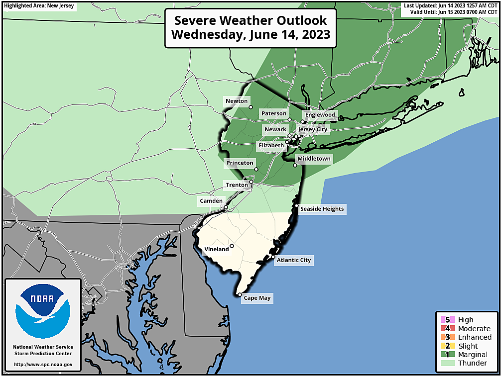
Rain and thunderstorms are absolutely not an "all day" thing. So let's carefully lay out the timeline of this unsettled day.
Wednesday begins with lots of sun, a few clouds, and temperatures in the 50s to around 60 degrees. So far so good.
Starting around 10 a.m., initial showers and thunderstorms will enter western Ne wJersey. By about 2 p.m., I expect everyone in the state to be seeing some rain. The epicenter for wet weather — the most widespread storms — will occur during the early to mid afternoon hours.
By mid to late afternoon, the rain will start to break up. However, models show one last grand finale round of spotty thunderstorms rolling through between about 4 p.m. and 7 p.m.
By sunset Wednesday, our weather will be completely dry and skies will start to clear.
It looks like we'll have just enough instability (potential energy) and humidity (moisture) for some stronger storm cells to develop. Best chance for gusty winds, a downpour, and/or some wicked lightning will be in northern New Jersey.
Rainfall totals will end up around a quarter-inch, give or take, with locally higher amounts.
The rest of Wednesday will be breezy, with occasional peeks of sun. High temperatures will be a couple degrees cooler than on Tuesday, around 75 to 80 degrees.
Wednesday night will feature clearing skies and quiet weather. Lows will dip into the comfortable, seasonable upper 50s
Thursday
Just like Tuesday, we will enjoy another beautiful June day. Mostly sunny skies, low humidity, dry weather, and warm temperatures. Highs will hit about 80 degrees.
Friday
Our next storm system rolls in throughout the daytime hours Friday. And while the areas of rain look spottier — spread farther apart — this one looks a bit more impactful. Higher humidity, richer moisture, stronger storms, and heavier rainfall.
I have to include the chance of a shower or thunderstorm pretty much all day Friday — from dawn to dusk. It's not a washout, as you'll find breaks of dry (although cloudy) weather along the way.
High temperatures on Friday will scale back slightly, to 75 to 80 degrees. As the dew point surges into the 60s, it will feel stickier and more humid too.
Saturday
It's the last weekend of Spring. And Father's Day Weekend. Also, for some lucky NJ kids, the first weekend of summer vacation.
Weather for most of the weekend will cooperate. But I just can't completely rule out a quick-hit isolated shower around lunchtime Saturday.
For the rest of the day, we'll see sunshine with scattered clouds. High temperatures will push toward 80 degrees again, with a stiff breezel
Sunday
Father's Day Sunday is now trending dry. And quite warm, with highs in the lower 80s. A nice summerlike day, with partly to mostly sunny skies. A sea breeze should keep beaches cooler and comfortable.
The Extended Forecast
I think the "occasionally unsettled" weather pattern will generally continue next week. Although it looks like less of a "day-to-day flip-flop" situation like this week.
There is a chance of a thunderstorm each evening next week, putting hundreds of graduation ceremonies at risk. But none of them are a "slam dunk" at this point. We will continue to keep you updated — let's get through Wednesday's and Friday's storm systems, and then we'll have better clarity on the medium-range forecast.
By the way, the Summer Solstice officially arrives next Wednesday 6/21 at 10:57 a.m.
BEEP BEEP BEEP: These are the 13 types of Wireless Emergency Alerts auto-pushed to your phone
Gallery Credit: Dan Zarrow
Dan Zarrow is Chief Meteorologist for Townsquare Media New Jersey. Follow him on Facebook or Twitter for the latest forecast and realtime weather updates.
11 reasons why storm chasing in NJ is a very, very bad idea
Gallery Credit: Dan Zarrow
More From 92.7 WOBM


