
Monday NJ weather: Quick burst of snow to the north, just rain to the south
What Changed?
Another Monday, another winter storm. Only "nuisance snow" is in the forecast for Monday, only for a brief time, and only for part of the state. However, there could be a few tricky hours in the middle of the day, as heavy snow falls and accumulates.
Models have been remarkably consistent with this temperature and precipitation type forecast. That gives meteorologists confidence that we know how the storm will play out.
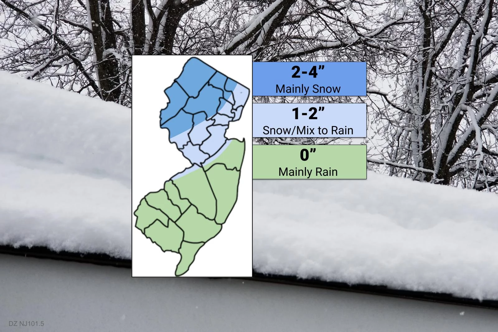
The biggest change since my Sunday weather blog is a slight increase in moisture and slight decrease in temperatures. The end result: More snow, for the "snow zone" of North Jersey.

I decided not to adjust the contours of my latest snow/impacts map at all. I did increase snowfall expectations within that northern third to half of New Jersey by approximately one inch.
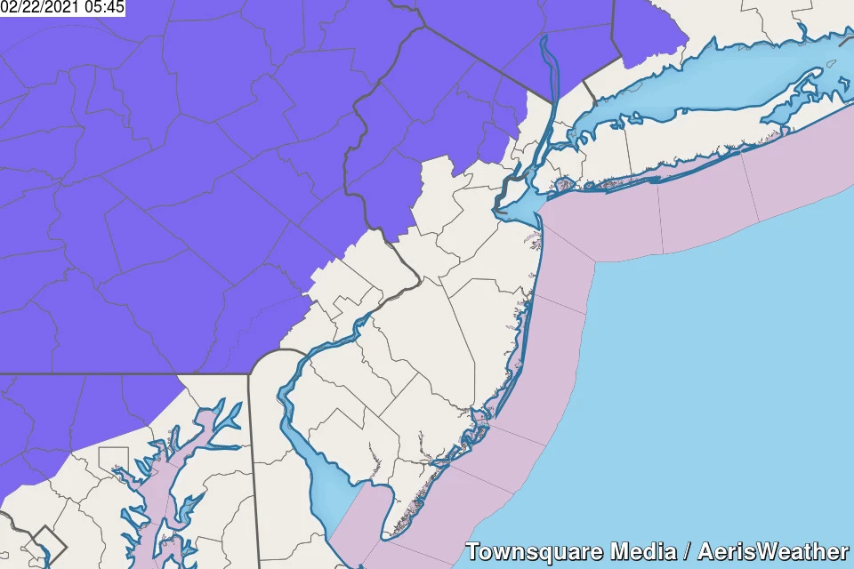
The National Weather Service's Winter Weather Advisory has also been expanded to cover all or part of seven North Jersey counties: western Bergen, western Essex, Hunterdon, Morris, Passaic, Sussex, and Warren. The advisory goes from 9 a.m. or 10 a.m. until 6 p.m.
Storm Rundown
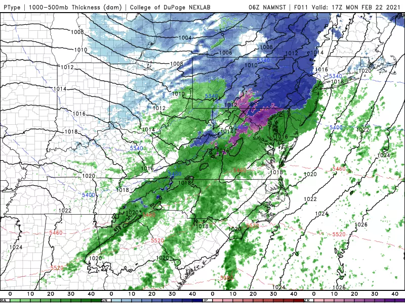
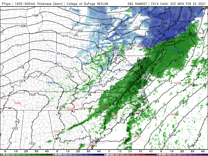
This fast-moving clipper system will impact New Jersey from midday through early evening. From lunchtime to dinnertime. From about 11 a.m. to 7 p.m. Since there is a clear "brunt" and a subsequent snow-to-rain transition, let's break that down further:
—Late morning... Precipitation arrives from the west. All snow to start, west of the NJ Turnpike corridor. And on onset, that snow will be heavy in spurts, leading to low visibility and quick accumulations. All rain to the south and east.
—Early afternoon... As temperatures rise above freezing along the NJ Turnpike corridor, snow will change to wintry mix and then plain rain. Still some heavy snow in NW NJ. Still wet to the southeast.
—Late afternoon... Precipitation intensity dials back a bit. Rain-snow line will be pretty close to the NJ-NY border at this point. Roads will (hopefully) be primarily wet and somewhat slushy heading into the PM rush hour.
—Early evening... Final raindrops exit. Clearing skies overnight. A flash freeze and widespread icing are not anticipated.
Accumulations & Impacts
The colder higher-elevation area of northwestern New Jersey is most likely to be the snow bullseye here, with 2 to 4 inches of total snowfall. Some model calculations go as high as 5" — that's pretty impactful snow, but I think such totals will be localized, at best.
The area generally along the NJ Turnpike corridor (from exit 6 to 18) will see a couple hours of steady snow, totaling 1 to 2 inches on the ground before the inevitable flip to rain. Not enough to plow, possibly enough to shovel. Things will remain slushy through the afternoon and evening.
And to the south and east, I wouldn't rule out a few snowflakes at the very beginning of this thing — especially if it arrives faster than expected. But no accumulation or wintry travel impacts here. You'll be reaching for umbrellas instead of snow shovels, with a half-inch of plain rain across southern and coastal New Jersey.
So conditions will range from "inclement" to "wintry" for a few hours. Even a few inches of fresh snow is enough to make travel sloppy — especially when the ground is cold enough to sustain immediate stickage. It's not a major "bread and milk" winter storm, but you'll have to pack your common sense, patience, and extra caution for sure.
The Rest of the Week
We'll dry out and clear out Monday night, with low temperatures in the lower 30s.
On Tuesday, a stiff southwesterly breeze will warm temperatures into the lower to mid 40s across the state. We'll see a mix of clouds and sun. I would lean toward a brighter forecast, but a batch of rain/snow showers will sweep through northern and central New Jersey around the midday hours.
Wednesday looks pretty fantastic! Partly sunny skies will pair with mild temperatures, in the upper 40s to lower 50s. There is a chance of a late-day rain shower, associated with an approaching cold front.
Tuesday and Wednesday will be our first pair of above-normal days in more than two weeks. That trend reverses on Thursday as cooler air returns. Highs will drop to 40 degrees again, although sunshine will help cut through that chill.
Friday looks cool but sunny, with highs in the lower-mid 40s.
And then our next significant storm system is set to arrive around Saturday. At the moment, both the GFS and Euro models put New Jersey on the warm side of the storm, with widespread 50s on Saturday. But the warmth will be hard to enjoy, with periods of rain for most of the day.
It's a precarious forecast, because a little storm track shift could put NJ into a snowier scenario. That hit-or-miss, rain-or-snow call will start to really firm up around Wednesday or Thursday.
Dan Zarrow is Chief Meteorologist for Townsquare Media New Jersey. Follow him on Facebook or Twitter for the latest forecast and realtime weather updates.
10 ways to know you're from New Jersey
More From 92.7 WOBM


