Heavy rain and wind could affect pre-Thanksgiving travel in NJ
The Bottom Line
The big pre-holiday travel rush is already on, peaking over the next two days. And we have a potent storm system that we have been watching for almost a week now. I want to be crystal clear about two things immediately:
1.) This is not a "winter" storm. There could be some very brief wintry mix around Sussex County Tuesday evening, but snow accumulations will stay well north of New Jersey.
2.) The worst weather — the heaviest rain and gustiest winds — will come overnight. That is fortuitous for road/air travel, but not a perfect situation.
Today's edition of the CMDZ weather blog is heavily focused on the timing of these stormy impacts. Our weather gets significantly quieter (and cooler) for most of Wednesday, Thanksgiving Thursday, Black Friday, Small Business Saturday, and Travel-Back Sunday.

Tuesday
Your Thanksgiving Eve Eve is starting off quiet, although chilly. Most of the state has dropped to around the freezing mark, with colder 20s to the northwest and warmer 40s along the Jersey Shore.
High temperatures Tuesday will reach about 50 degrees, give or take. Realistically, thermometers may range from mid 40s north to mid 50s south.
Skies will be mostly cloudy to overcast throughout the day. And a breeze with kick up to about 20 mph too.
Rain will start to spread into NJ from the west in the afternoon. Just some scattered light stuff initially, which may dampen your commute home.
Tuesday Night
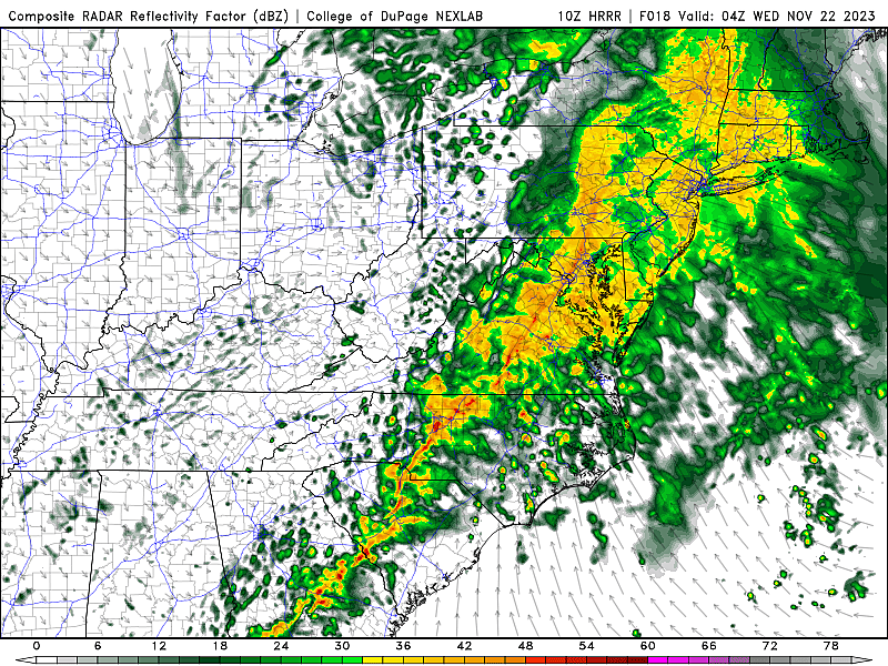
The "brunt" of the storm — the period with the heaviest rain and strongest winds — will come between about 6 p.m. Tuesday and 6 a.m. Wednesday. Centered on the late night and early morning hours.
Temperatures will rise well into the 50s as this storm system plays out. Well above freezing. That is why we are talking about wet and not wintry weather here. Having said that, I think there is a limited opportunity for some wet snowflakes for an hour or two, around Sussex County, around sunset. That's it — no accumulation, no additional travel impacts. (Although if you're traveling north into Upstate New York or New England, you may run into some snow issues.)
Statewide total rainfall by Wednesday morning will likely reach the 1 to 2 inch range. (Literally all forecast models show similar numbers, with locally higher amounts possible.)
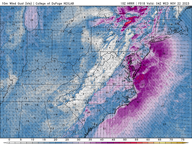
Wind gusts will hit about 30 to 40 mph. (A few gusts along the immediate coast may surpass 40 mph.)
Because that will be an on-shore wind, coastal flooding becomes a potential problem too. 1 to 2 feet of surge may cause minor category flooding during the overnight high tide cycle.
One more important impact to talk about. This is not a good time of year to have a rain/wind storm. All over New Jersey, roadside leaf piles are blocking storm drains, raising the risk for localized ponding and flooding. Plus, the heavy rain and wind will cause substantial leaf fall. Wet leaves covering road surfaces can be very slippery.
So there are some alarm bells to ring here. The holiday-travel-season timing is not ideal. There is a risk for some flooding and wind issues. Maybe even some rumbles of thunder. But nothing overly wintry or severe. And we do need a good soaking, given our very dry November so far.
Wednesday
Rain showers will wrap up around mid-morning on Wednesday. And then our weather will gradually improve.
We should see increasing peeks of sun through the afternoon. With high temperatures still on the mild side around 55 to 60 degrees.
It will still be breezy Wednesday, with top winds in the neighborhood of 20 mph.
The air mass set to arrive on Wednesday is cooler, but not dramatically frigid. Temperatures may start to slide downward in the afternoon. By Wednesday night, we'll only drop into the 40s — still above freezing.
Thanksgiving Thursday
The only potential issue on Thursday is the breeze, still in the 10 to 20 mph. And that could be a problem for the parade balloons in both New York City and Philadelphia. They have very strict limits about when they can fly at full height, and gusts may still be borderline Thursday morning.
The rest of your Turkey Day is trending dry and mostly sunny. And we can add seasonable to that description too, with highs settling in the lower 50s. That is pretty typical for this time of year.
Black Friday
A reinforcing shot of cold air arrives for Friday, adding a real chill to the air for the remainder of the holiday weekend.
Highs on Friday will be limited to the mid-upper 50s. The wind will be calmer, but still noticeable.
I'm keeping a dry forecast on Friday. However, a storm system passing south of New Jersey will keep our skies mostly cloudy.
The Extended Forecast
Saturday will be the coldest day of the week, a morning deep freeze in the 20s and highs only reaching about 40 degrees. (FYI, 40 is the normal high in the "dead" of winter in January.)
Temperatures will stay unseasonably chilly through Sunday (40s), then moderating to around 50 for Monday. Model guidance hints at some potential rain showers in the late Sunday to Monday time frame. No big headache for homeward travelers as it stands, but worth keeping an eye on.
First flakes: When does snow season start in NJ?
Gallery Credit: Dan Zarrow
Dan Zarrow is Chief Meteorologist for Townsquare Media New Jersey. Follow him on Facebook for the latest forecast and realtime weather updates.
Thanksgiving snow? When it happened, & the odds in NJ for 2023
Gallery Credit: Mike Brant
More From 92.7 WOBM