
Flash Flood Watch: A soaking, stormy start to the holiday weekend
Hi there. While you won't hear my voice on the radio, I'm taking a vacation from my vacation to present the latest on the heavy rain and strong thunderstorms that may impact your Good Friday, Passover, and/or Easter plans.
The culprit for the inclement weather is a deepening area of low pressure, which looks to track directly over New Jersey in the coming days. Let's step through this complicated and occasionally yucky forecast one piece of the weekend at a time.
Friday Morning
We're kicking off this Good Friday morning with clouds and mild temperatures, holding around the 60 degree mark. (That's almost 20 degrees above normal for mid-April, by the way!) Skies are mostly cloudy to overcast across the Garden State, and that's how they'll remain for the rest of the day.
In terms of rain, the chance will be pretty minimal to start the day. Spotty showers and sprinkles are possible — but the center of this storm system is still something like 600 miles southwest of us. So initial rainfall will be very much hit-or-miss. (Mostly a miss.)
Friday Afternoon and Evening
Our weather will turn more unsettled as the afternoon and evening goes along. At first, nothing incredibly organized, and the rainfall won't be truly steady or heavy yet. Scattered showers and thunderstorms look to really fill in after about 4 p.m. Friday.

There is a chance for a gusty thunderstorm cell in this time period too, particularly along the western edge of New Jersey. Especially if you catch a few rays of sunshine at some point Friday, adding to the energy (instability) of the atmosphere. Not the peak of the storm just yet, but something to watch.
Despite the thick clouds and sporadic raindrops, you are going to feel some humidity in the air. High temperatures should make a run for 70 degrees for non-coastal New Jersey. (Just like Wednesday, we'll be stuck close to 60 degrees at the Jersey Shore.)
Friday Night to Saturday Morning
Here we go. Primetime for this storm system will kick-in for New Jersey between about 2 a.m. and Noon Saturday. (As usual, I have to leave a "buffer zone" with a fairly big window of time there, given the uncertain spread of model solutions.) It's pretty clear that the best chance for heavy rainfall will be right in the heart of that window, surrounding sunrise Saturday morning.
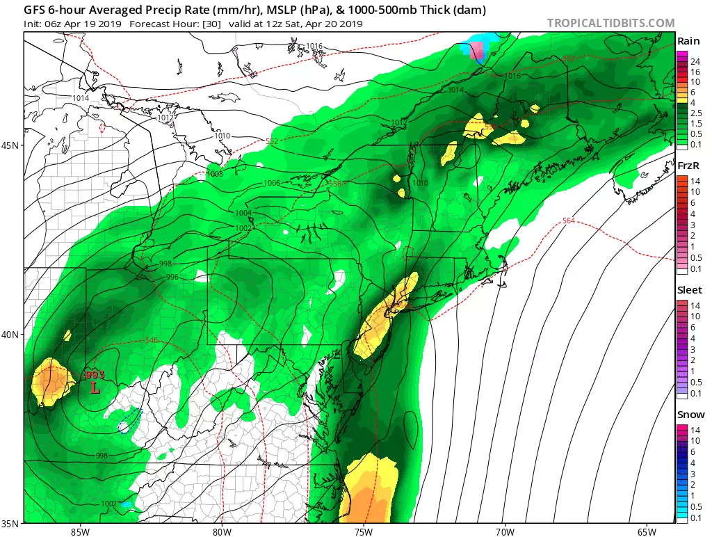
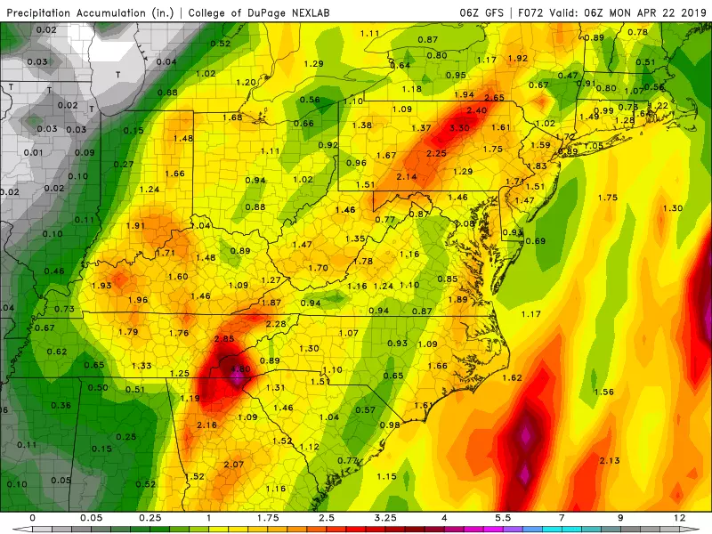
And I do mean heavy. We are going to tap in to some very rich moisture from the Gulf of Mexico and the Caribbean Sea. On the low end of forecast guidance is the NAM, which paints only a half-inch of total rainfall for most of NJ. That seems like a low outlier to me. The Euro and GFS fall closer to 1-1.5 inches of rainfall, which seems the more reasonable solution. Of course, just a little bit to the west in Pennsylvania, models suggest that anywhere from 2 to 4 inches of rain — that will almost certainly cause flooding issues.
Back home in New Jersey, we do have a Flash Flood Watch posted for the following counties, through the following times:
--2 p.m. Friday to 10 a.m. Saturday... Hunterdon and Warren.
--2 a.m. to 2 p.m. Saturday... Bergen, Essex, Hudson, Mercer, Middlesex, Passaic, Somerset, Sussex, and Union.
If torrential downpours inundate drainage systems, we may end up with "big puddles" (i.e. flooding) on the ground. Remember to never attempt to walk, swim, or drive through flooded areas — it is very dangerous, and quite disgusting too.

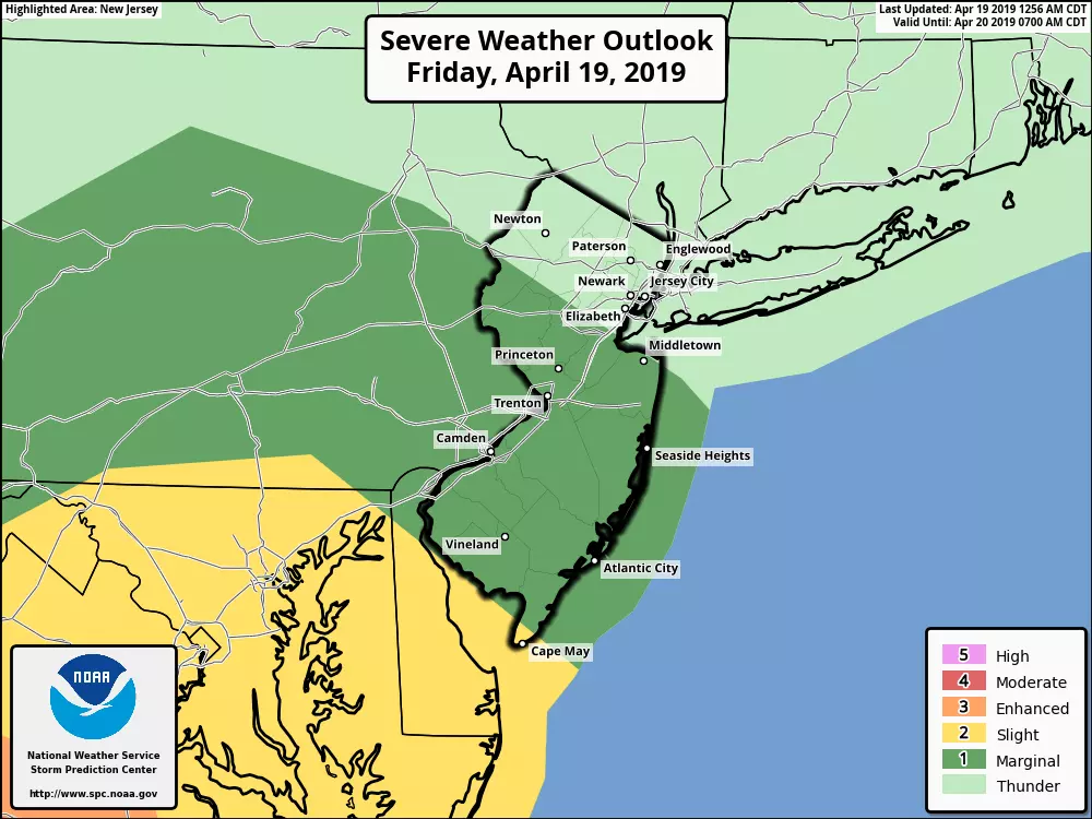
Another concern early Saturday morning will be severe weather, particularly due to gusty winds. (Although some hail and an isolated tornado can't be ruled out.) For the second time this week, we could see a line of strong to severe thunderstorms passing across New Jersey. The Storm Prediction Center has put almost all of NJ in a Marginal Risk for severe weather — the bigger risk for dangerous storms, by far, will be to our south.
We have also been watching the potential for some coastal flooding from this system. But the storm's latest track does not raise significant alarm bells. Surface winds are going to be out of the south for most of the storm, a trajectory which may push some extra water up the Delaware River (for example). I suppose vulnerable areas along the Jersey Shore (the "usual" spots) could experience minor tidal flooding, with up to a foot of water rise. But it's really not our primary concern here.
Saturday Afternoon and Evening
Much drier and quieter. While there could be a few leftover showers through Saturday early afternoon, the late afternoon and evening hours look almost totally dry across New Jersey. If you're lucky, you might even catch a few peeks of sunshine!
High temperatures on Saturday will be around the mid 60s, just above-normal for this time of year. As cooler, drier air filters in on the backside of this system, temperatures may begin to fall a bit before sunset.
Sunday
I have a keep a few showers in the forecast on the backside of this storm, particularly Sunday afternoon. But that's it — mostly dry, nothing steady or heavy, and nothing severe. That's good news for anyone traveling for the Easter holiday.
Clouds will continue to win the sky. But, just like Saturday afternoon, you might catch a cameo appearance by the sun at times. Morning low temperatures will be near 50 degrees, with afternoon highs in the lower 60s.
Early Next Week
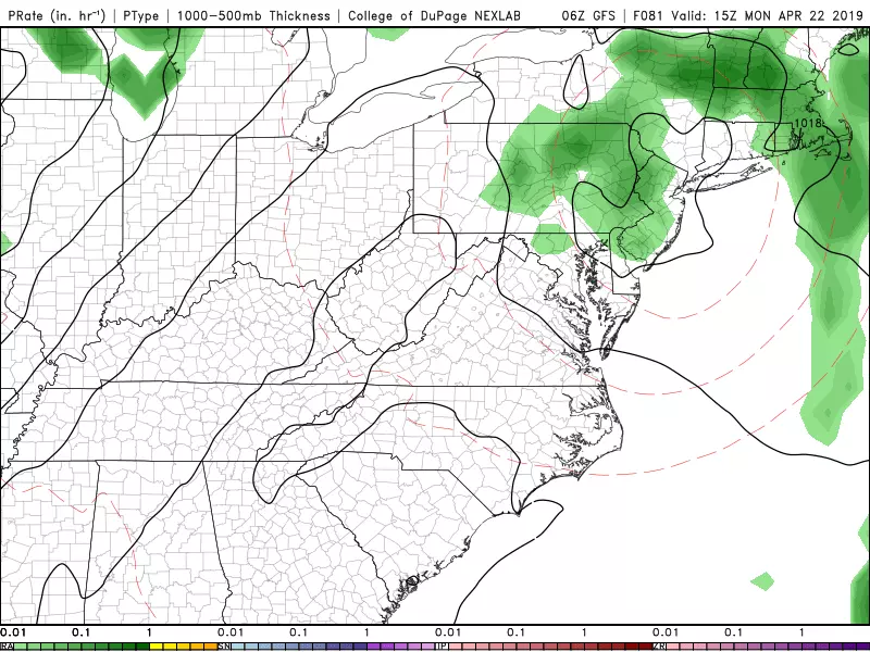
I had been predicting a great weather day for Monday, but the latest forecast drifts quite a bit from such perfection. A few consecutive model runs have latched on to the idea of an annoying secondary low passing over the Garden State on Monday. That would lead to scattered showers, clouds, and temps stuck in the 60s. Unfortunately, there is a reasonable chance for a pretty grey, damp, and cool start to the workweek.
No need to despair though, New Jersey. If all goes well, we'll bounce back nicely on Tuesday. Sunshine and upper 70s!

Of course, don't get used to the warmth and pleasantry. Cooler air and raindrops return around the middle of next week.
Final Thoughts
Lots of travel and lots of activities planned for this holiday weekend. For the third weekend in a row, New Jersey will experience an imperfect blend of heavy rain alongside glimmers of dry, nearly-pleasant weather along the way. It's important to take the downpour and thunderstorm threats seriously — if possible, you really don't want to be out in the elements during the peak of this storm (again, Saturday morning).
No matter what you're celebrating this weekend, I truly hope you have a safe and enjoyable time. I'll be back on the air dark n' early Monday morning!
Dan Zarrow is Chief Meteorologist for Townsquare Media New Jersey. Follow him on Facebook or Twitter for the latest forecast and realtime weather updates.
More From 92.7 WOBM


