Eyes on Ida: More tropical rainfall, more flooding for NJ midweek
The Bottom Line
Hurricane Ida made landfall in southeastern Louisiana on Sunday as a powerful category 4 storm, with maximum sustained winds of 150 mph. The scenes being broadcast from there are nothing short of catastrophic.
As that devastation continues to play out along the Gulf Coast, our attention turns to where Ida goes next. It will continue to weaken, while making a right turn right toward us.
Given the forecast storm track and the tropical moisture in play, it is not a matter of if it's going to pour in New Jersey this week. It's a matter of when and just how much.

Background
As of 5 a.m. Sunday, Ida has weakened to a tropical storm with max sustained winds of 60 mph. It was centered over southwestern Mississippi, approximately 1,000 miles southwest of New Jersey.

We are clearly in the "cone of uncertainty" there. That official forecast track puts Ida's center over NJ around Thursday midday. That emphasis is important because the storm won't be a single point, it is about 200 miles wide. And the strongest part of Ida will be in front of its center.
Keep in mind also that the forecast track is subject to change and "wiggle" as the storm comes closer. There's a lot of "chaos theory" in effect in meteorology. In other words, a little adjustment (of just a few miles, for example) could have huge implications on who gets flooded, who gets wet, and who stays dry.
Timeline
The first half of the workweek will be unsettled and humid, but we won't have to battle Ida impacts just yet.
Monday starts with temperatures in the 70s, with highs probably reaching the mid to upper 80s in the afternoon. Add in the humidity and the heat index will probably hit 90s — not "dangerous heat," but not incredibly comfortable either. We'll see breaks of sun throughout the morning. And then spotty thunderstorms will probably visit later on. Best chance of rain looks to be after 5 p.m.
Tuesday should be OK. Mostly cloudy skies, seasonable highs in the 80s. And once again, a slight chance of late-day raindrops.
At the moment, forecast models show Ida's remnants to soak New Jersey in the Wednesday-Thursday time frame. More specifically, the heaviest rain and nastiest weather is expected late Wednesday night through Thursday morning.
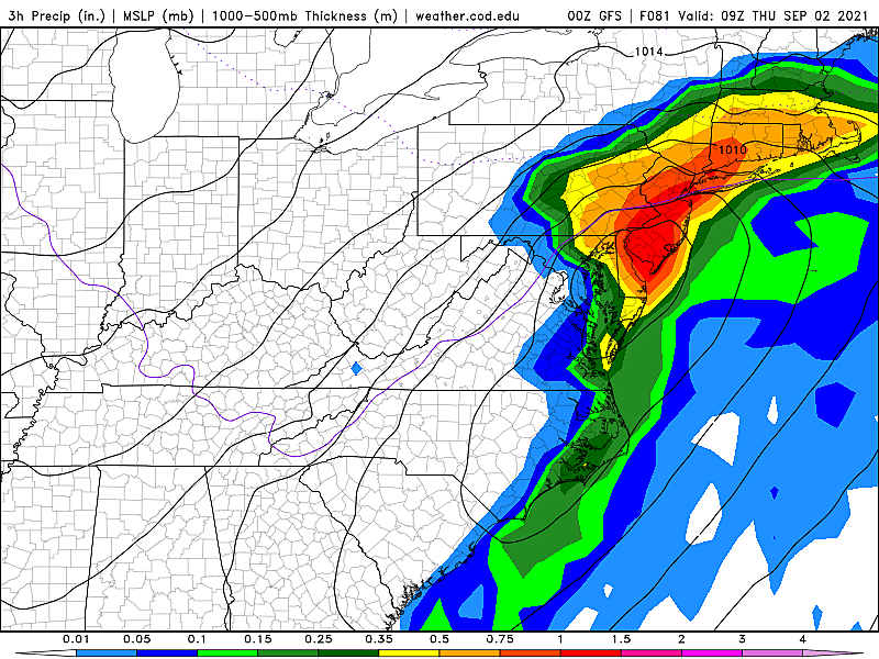
If this timeline stays on target, our weather will go downhill as initial rain bands creep in during the day on Wednesday. On the other side, there's a good chance sunshine breaks out Thursday afternoon. (Beginning a trend of dry, pleasant weather that will hopefully last through the Labor Day Weekend, by the way.)
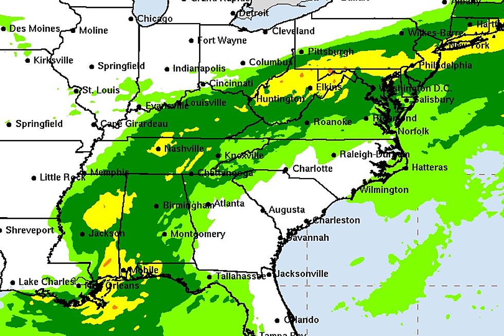
The Biggest Concern: Heavy Rain & Flooding
It has been a wet summer, to say the least. In just the last two weeks, we had the remnants of Tropical Storm Fred and then Tropical Storm Henri dump many inches of rain and cause some truly dramatic flooding in parts of New Jersey.
It is important to note that all river gauges in New Jersey have dropped below flood stage since Fred's and Henri's visits. And I wouldn't call the ground "saturated" at this point, but it's definitely not "dry" either.
A Flash Flood Watch has already been issued for most of New Jersey, from Wednesday morning through Thursday evening. (I'm sure the northeast corner of the state will be added to the watch soon.)
Rule number one in hurricane forecasting: Never underestimate the rainfall potential of tropical moisture. Ida has plentiful moisture. Therefore, Ida is probably going to dump a lot of rain and cause big flooding issues again. That is "freshwater" or "inland" or "flash" flooding, caused by overflowing waterways and inundated storm drains. Not "coastal" necessarily.
How much rain? I estimate 3 to 6+ inches across New Jersey.
Who gets hit the hardest? That is the big question, of course. As of the latest model run, the bullseye appears over the middle of NJ. But that geography is extremely track dependent, subject to slide either north or south by even 50 to 100 miles. That is a huge source of uncertainty in this forecast.
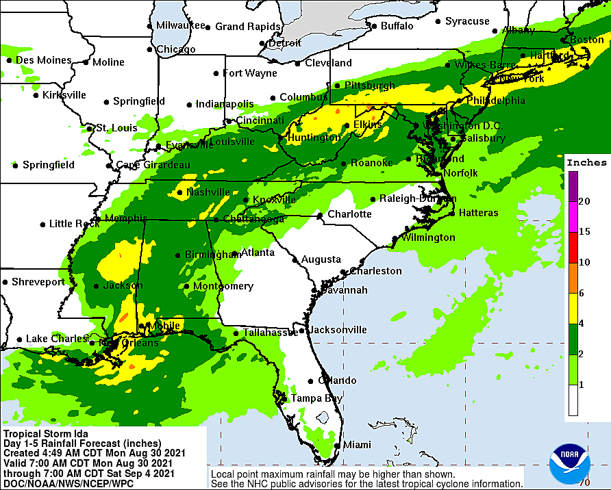

Everyone in NJ should prepare for a thorough drenching.
Other Potential Issues
—Severe Weather... Not only has it been a hot, wet summer, it has been a tornadic one too. 10 confirmed tornadoes in NJ so far in 2021. Storm systems of tropical origin are notorious for causing quick spin-ups, as we saw from Elsa in July and Fred in August. Ida will have some tornado potential too, especially just south of the storm's center. Therefore, South Jersey is under the gun for the highest risk of severe early Thursday morning.
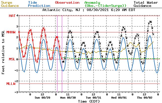
—Storm Surge... As I showed above, Ida is approaching from the southwest — the land-side, not the ocean-side. So substantial storm surge, swell, ocean waves, and an elevated rip current are not expected. However, depending on the wind direction and speed as the storm passes, it wouldn't take much to push a foot or of extra water toward the coast. That's enough for widespread minor category coastal flooding. The highest high tide cycles look to be on Thursday.
—Wind... At the bottom of the list for a reason. Ida is not going to be a hurricane by the time it reaches New Jersey. Not even close. Having said that, we could still see a narrow corridor of wind gusts in the 40 to 60 mph. Combined with soaking rain, that could absolutely bring down trees and power poles. It will further reduce visibility during rainfall ("blowing sideways") and may relocate your garbage can too.
What Now?
As I pointed out in the hours and days before Henri's fly-by earlier in August... What would you do to prepare for a 1-inch rainfall? And how would you get ready for 10 inches of rain?
The answers to those two questions may be very similar for you. And the answers may be "Nothing at all." This is not the kind of storm for which you need to make a run on the grocery store. You won't need to board up or evacuate before the storm hits.
At the very least, know that we face a period of nasty weather and challenging travel conditions between Wednesday and Thursday. Flooding, downed trees, closed roads, and power outages are possibilities. Planning to stay home would be a great idea, if possible.
What's Next?
We'll continue to dial in the details, providing play-by-play of the forecast as it continues to develop. My next in-depth weather blog post will probably be published Tuesday morning. And then we're planning to launch into full weather, news, and traffic coverage during the height of the storm Wednesday and Thursday.
Yup, vacation's over. The weather never sleeps.
Dan Zarrow is Chief Meteorologist for Townsquare Media New Jersey. Follow him on Facebook or Twitter for the latest forecast and realtime weather updates.
100 Best Jersey Shore Beach Views
More From 92.7 WOBM


