Another wintry mess for NJ Thursday-Friday: More snow, more ice
I feel like I've used the words "another" and "more" in my weather blog excessively over the last month. I should really just setup a hammock and mini-fridge in the weather center and live there during the winter months.
We have another winter storm looming for Thursday — a messy progression of snow, sleet, freezing rain, and rain that will impact the entire state. Both snow and ice accumulations are on the table here. And I'm especially concerned as the heaviest precipitation is expected during the daytime hours on Thursday. That means road conditions could be dramatically different during the morning commute, the lunch rush, and the evening ride home.

As of this writing, we are about 40 hours away from first flakes. And forecast models are showing really shaky consensus on how this storm will play out for New Jersey. Little differences in the track, the timing of warming temperatures, and the overall intensity of precipitation bands will have big implications for what ends up on the ground.
In this post, I'm just laying out the basics of what we know so far. I'll have much more to say over the next day and a half, as we gain a more confident understanding of this dynamic storm system.
Timeline
The storm will play out in approximately four phases, from Thursday to Friday. The timing and geography of each part is a little hazy, but we'll refine and get more specific with those impacts as it draws closer.
1.) Initial Burst of Snow... Thursday morning to midday... This storm is probably going to arrive with a bang. Initial snowfall rates within the heaviest snow band(s) may exceed 1 to 2 inches an hour. The cold ground will allow that snow to stick almost immediately, leading to rapid accumulation. Travel conditions (visibility and traction) will deteriorate quickly for most of the state during the day Thursday.
2.) Transition to Icy Mix... Thursday afternoon to evening... As the layer of the atmosphere about a mile overhead warms, snow will turn to sleet and/or freezing rain. This transition will happen relatively quickly in South Jersey, with the mixing line then slowly progressing from south to north. Sleet does not accumulate the same way as fluffy snow does, but this temperature profile is conducive to some ice accumulation. Precipitation intensity should dial back during this time frame too.
3.) Transition to Rain... late Thursday... The lowest layer of the atmosphere will eventually warm up too, and that means we'll flip to a period of plain rain for approximately the southern half of the state. Snow will turn to slush, ice will melt, and conditions will still be sloppy.
4.) Quick Flip Back to Snow... Friday morning to midday... Cold air will "whoosh" into New Jersey behind the storm. And if temperatures drop below freezing before the last little impulse rides through, precipitation may briefly flip back to snow to close out the storm. Some models even hint at an additional inch or two of accumulation during this time frame.
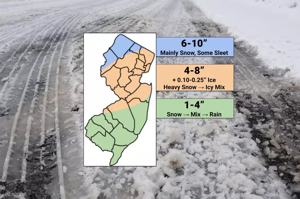
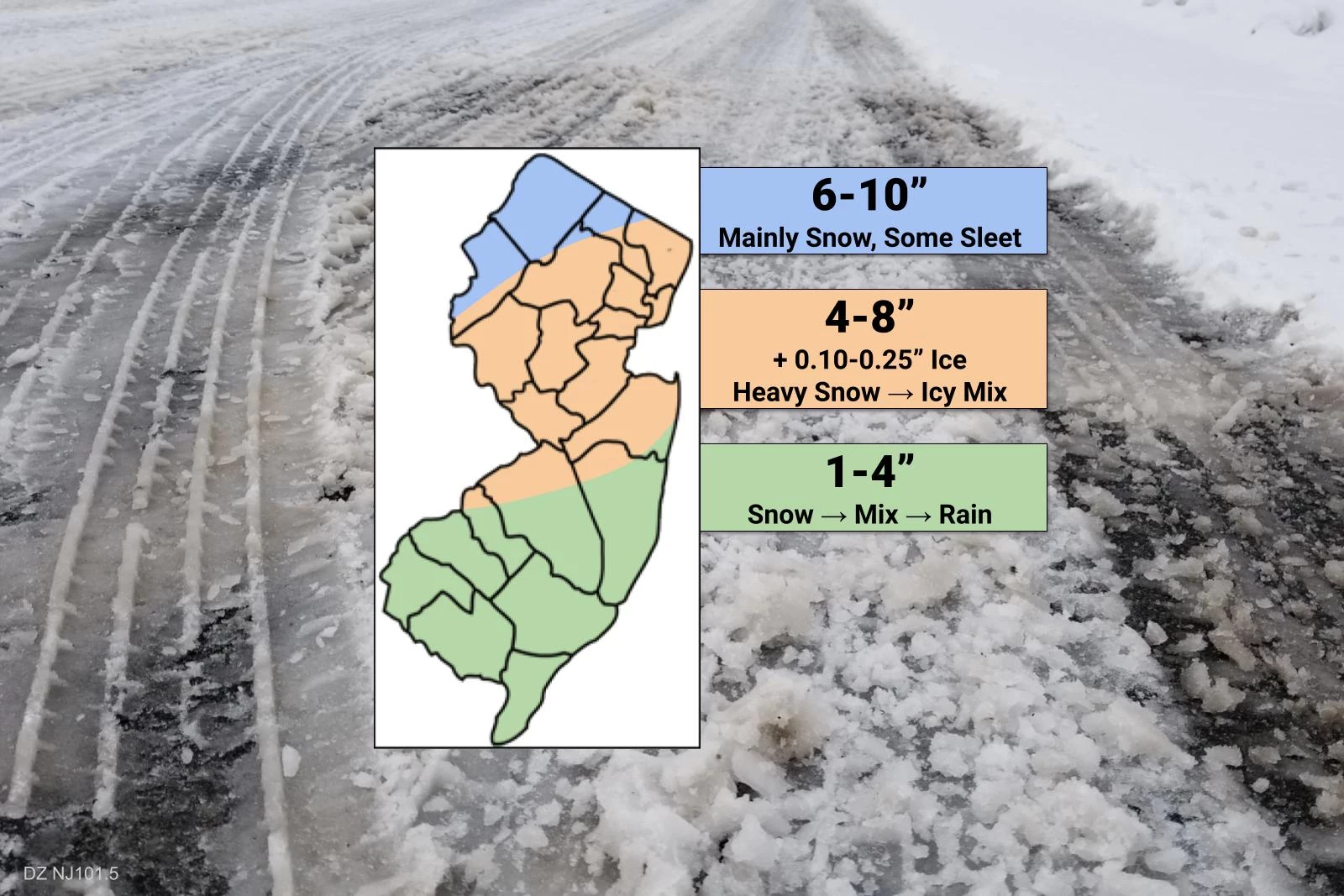
Accumulations
I fear this forecast has a very high "bust" potential because of one aspect in particular — the sleet. (Phase 2, above.) If expectations for the timing and extent of those ice pellets is off by just a little bit, snow and ice accumulations could easily underperform or over perform.
I decided to be more aggressive than usual with my snowfall forecast for the northwest corner of the state. The transition to sleet may not happen in this region, allowing for almost 24 hours of steady-iso light to moderate snow, totaling between 6 and 10 inches. (It seems like every storm we've had in this series ultimately wiggles to the northwest, so I'm somewhat compensating for that here too.)
The middle part of New Jersey will be the ultimate battle zone between snow and sleet. In addition to 4 to 8 inches worth of moderate to heavy snow, a period of 1/10-inch to 1/4-inch of ice accumulation is a possibility here through Thursday night. If the forecast leans colder (even for just a couple of hours), the snowier solution will play out. If it's warmer, it will be sleetier and icier. I'm not sure there's a best-case scenario here, really.
South Jersey is tricky too, because snow could flip to sleet and rain very quickly, kiboshing any hopes of a white, wintry scene. In this first call, I did put at least an inch of snow accumulation for everyone. And if a heavier snow band parks over this area for an hour or two, a quick accumulation of 1 to 4 inches is possible by Thursday afternoon. I was tempted to divide this section of the state into Trace-2" (close to the coast) and 2-4" (inland), but I wasn't sure exactly where to draw that line. I might make that differentiation in future snowfall maps for this storm.
Impacts
The bottom line... As the headline of this post suggests, there's no doubt this storm will be a wintry mess for every corner of New Jersey. Road conditions will slide downhill rapidly as slow moves in fast and hard Thursday, with ice accumulation a concern into Thursday night. There are still some big question marks to resolve regarding precipitation type and timing — we will make adjustments as needed between now and "first flakes".
In addition to the wintry weather, we'll have to watch the coast for one to two rounds of minor coastal flooding. The period and strength of northeasterly winds will be limited, but tidal guidance still shows almost a foot of surge on Friday morning.
Finally, it's going to get very cold again this weekend. Low temperatures Saturday morning will probably be in the teens. So you'll want to clear any snow from driveways, sidewalks, and vehicles quickly, as a hard freeze will ice everything over soon enough.
Winter Storm Watch
The National Weather Service has issued a Winter Storm Watch for non-coastal New Jersey, as follows:
—4 a.m. Thursday to 1 p.m. Friday... NW Burlington, Camden, Gloucester, Hunterdon, Mercer, Middlesex, inland Monmouth, Morris, Salem, Somerset, Sussex, and Warren counties.
—6 a.m. Thursday to 6 a.m. Friday... Bergen, Essex, Hudson, Passaic, and Union counties.
A watch is your 2-day heads-up that potentially hazardous winter weather is coming. If the forecast holds, that will be upgraded to warnings tomorrow. (With advisories where snowfall is expected to fall short of warning criteria.)
My accumulation forecast is largely in line with the NWS, and I fully support where they drew this watch. Thumbs up!
What's Next?
We'll continue to monitor the latest changes to the forecast, and communicate the play-by-play. I'm planning on two weather blog posts for Wednesday, one early morning (by 7 a.m.) and one in the afternoon (by 5 p.m.) Hopefully that will give you the information to plan accordingly to stay safe and prepared during yet another blast of Jersey winter.
Dan Zarrow is Chief Meteorologist for Townsquare Media New Jersey. Follow him on Facebook or Twitter for the latest forecast and realtime weather updates.
MORE: Why ice storms are so problematic for NJ
More From 92.7 WOBM


