8 things to know about NJ’s nasty nor’easter
The snow threat remains very limited, but heavy rain, fierce winds, and high surf will still batter the Garden State late Sunday through early Tuesday.
1.) Background
New Jersey is waking up to some dense fog on this Sunday morning. Visibilities are below a quarter-mile in many locations. Meanwhile, a band of rain - which I'm calling an "appetizer" for what's to come later - has enveloped the southern coast.
As of this writing, the powerful storm system set to affect New Jersey is bringing severe weather to the Southeast United States. We're calling it a nor'easter because of its distinctive storm track paralleling the Atlantic coast, which causes fierce "nor'east" (northeast) winds.
Usually such coastal storms are the bearer of heavy snow and blizzard conditions in New Jersey. This time around, it's almost exclusively wind-swept rain.
2.) Advisories
The wide variety of warnings and advisories issued by the National Weather Service can be very complicated to sift through and understand, so I've compiled a summary here. I hope this provides a helpful county-by-county outline of the storm's greatest predicted impacts.
Dense Fog Advisory for visibility less than than a quarter-mile:
--until 10 a.m. Sunday... northwestern Burlington, Camden, Gloucester, Hunterdon, Mercer, Middlesex, Monmouth, Morris, Salem, Somerset, Sussex, Warren
High Wind Warning for sustained winds up to 40 mph, with gusts to 60 mph
--from 1 a.m. Monday to 1 a.m. Tuesday... eastern Essex, Hudson, eastern Union
--from 3 a.m. to 4 p.m. Monday... Atlantic, southeastern Burlington, Cape May
--from 3 a.m. to 9 p.m. Monday... Middlesex, Monmouth, Ocean
Wind Advisory for sustained winds up to 30 mph, with gusts to 50 mph
--from 3 a.m. to 2 p.m. Monday... Salem
--from 6 a.m. to 4 p.m. Monday... Camden, Gloucester
--from 6 a.m. to 7 p.m. Monday... northwestern Burlington, Mercer, Morris, Somerset
Coastal Flood Advisory for up to 3 foot surge, and up to 8 foot waves
--from 2 a.m. to 11 a.m. Monday... Atlantic, southeastern Burlington, Cape May, Cumberland, Middlesex, Monmouth, Ocean, Salem
--from 4 a.m. to 8 a.m. Monday... eastern Essex, Hudson, eastern Union
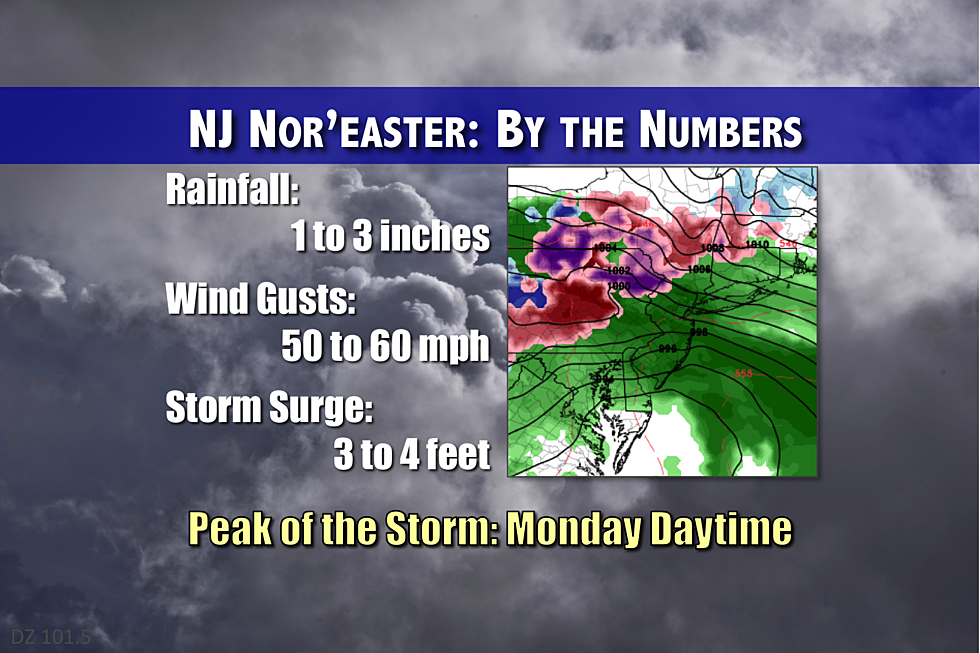
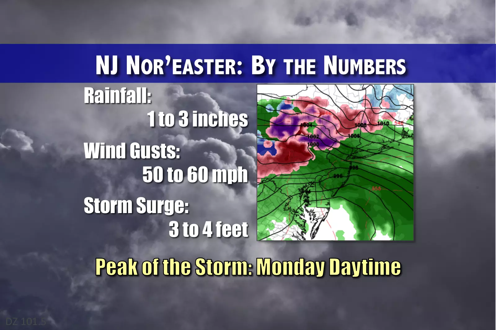
3.) The Brunt of the Storm
The daytime hours on Monday (morning through evening) will feature the heaviest rain, the strongest winds, and the highest surge.
4.) Detailed Timeline
Through 10 a.m. Sunday: "Appetizer" rain event affects New Jersey's south coast (primarily southern Ocean, Atlantic, Cape May, and Cumerband counties)
During the day Sunday: Mostly cloudy, mostly dry, and mostly mild. Thermometers may climb into the lower 50s again for the southern part of the state.
Sunday Evening (after 5 p.m.): Scattered light rain will spread northward through New Jersey.
Monday 7 a.m. to Tuesday 1 a.m.: The main event. Bands of very heavy rain, and wind gusts to 50-60 mph will spread through the state. Coastal flooding concerns will be greatest at the times of high tide.
Through Tuesday Midday: Residual rain is likely.
Through Tuesday Night: Winds will begin to calm and skies will begin to clear.
5.) Rain
The latest model roundup shows 1.2 to 2.9 inches of rain are forecast to fall across the Garden State. So, the statewide average will be about 2 inches - that's some healthy rainfall! Visibility and traction will obviously be very low in the heaviest downpours. And, if a lot of rain falls in a short period of time, flash flooding may occur.
6.) Winter
The threat for wintry weather will remain strictly limited to the area in and around Sussex County. With temperatures hovering around the freezing mark for the duration of this system, there's a chance for periods of freezing rain or snow along the state's highest elevations. Model consensus still shows a trace of snow and/or a trace of ice. But I have to mention that previous runs (and prior history) suggest totals could ultimately be a bit higher. It all depends on that magical 32-degree temperature mark.
7.) Wind
Do not underestimate how strong the winds will be with this storm. In fact, I suspect the wind will be the most memorable impact of this nor'easter. Inland New Jersey should expect east-northeast wind gusts to 50 mph, with gusts as high as 60 mph along the Jersey Shore. That's enough to down trees and power lines, causing scattered power outages. It will also blow around lawn furniture and garbage cans, so you'd be wise to secure them before the storm hits. Finally, controlling high-profile vehicles (like trucks, buses, and vans) may be difficult during the peak of the storm.
8.) Coastal Impacts
Minor to maybe moderate flooding of tidal waterways is expected. The high tide cycles of greatest concern will occur early Monday morning, Monday midday, and early Tuesday morning. (High tide occurs up to 3 hours later in the back bays.) The latest guidance shows storm surge of 2 to 4 feet. So, for residents along the coast, imagine where the high tide line comes up to on your dock or bulkhead, and go up 4 feet. Again, this event looks to fall in the "minor" category. Regardless, that's enough to cause roadways "that always flood" to close during high tide. Ocean waves up to 8 feet may cause moderate beach erosion.
Stay smart, stay safe! As always, we'll be here to bring you the latest updates throughout the storm. Next weather blog update expected early Monday morning.
More From 92.7 WOBM


