Beware the ‘hurricane hype’ – here’s how Lee may really affect NJ this week
The Bottom Line
The internet hype machine started to swirl this weekend, as Hurricane Lee continued to churn up the Atlantic Ocean. Yes, recent forecast models showed a slight shift to the west (closer to the coast). And yes, there was one scary outlier solution that showed direct storm impacts in New Jersey.
However, even with the storm's center about 1,300 miles away at this point, our general idea of Hurricane Lee's future impacts on New Jersey are holding steady. Significant rain, wind, and severe weather are unlikely. Big waves, beach erosion, storm surge, and coastal flooding are likely — and those are some big concerns. The storm will make its closest pass to New Jersey in the Friday-Saturday time frame.
Meanwhile, we had some pockets of very heavy rain (3+") and flooding over the weekend. We are in the midst of another very humid, unsettled period of weather. And there will be two more big pushes of soggy, stormy weather: late Monday and Wednesday.
A big pattern change arrives on Thursday, as deliciously dry air and dry weather returns.

Monday-Tuesday-Wednesday: Unsettled, Humid Weather Continues
The air is soupy and the ground is wet. And we're not done with the occasional downpours yet.
As of this writing (6 a.m.), there are some widely scattered pockets of rain around New Jersey. You may be dodging raindrops and/or puddles until mid-morning. It looks like we will catch a lull of drier weather after about 9 or 10 a.m. Skies will stay murky and mostly cloudy, as high temperatures hit about 80 degrees.
Scattered showers and thunderstorms will blossom once again starting mid-afternoon Monday, around 3 or 4 p.m. Not everyone gets soaked, but downpours and localized flooding issues are likely. A stronger storm cell could spit out some gusty winds and/or hail as well.
Monday night dries out, with possible fog. Thermometers will dip into the upper 60s.
Tuesday looks mainly dry too, with only a stray shower chance. Highs will push into the lower 80s, with a much brighter sky.
One more push of heavy rain is expected Wednesday morning, as a slow-moving cold front arrives from the west.. Rainfall totals may exceed an inch or two where it really pours, enough to ring flooding alarm bells once again. Showers may linger into part of Wednesday afternoon, before skies start to clear eventually.
Thursday: Deliciously Dry Air Arrives
By the time you wake up Thursday morning, humidity will be gone. Great news! An influx of dry air will push dew points from near 70 to the 40s on Thursday, adding a nice, refreshing feel to the air.
Thursday will be sunny and breezy. High temperatures will only reach the mid 70s, which is below normal for mid-September.
The low humidity will carry into the upcoming weekend too, although Lee draws near...
Friday-Saturday: Hurricane Lee's Impacts on New Jersey
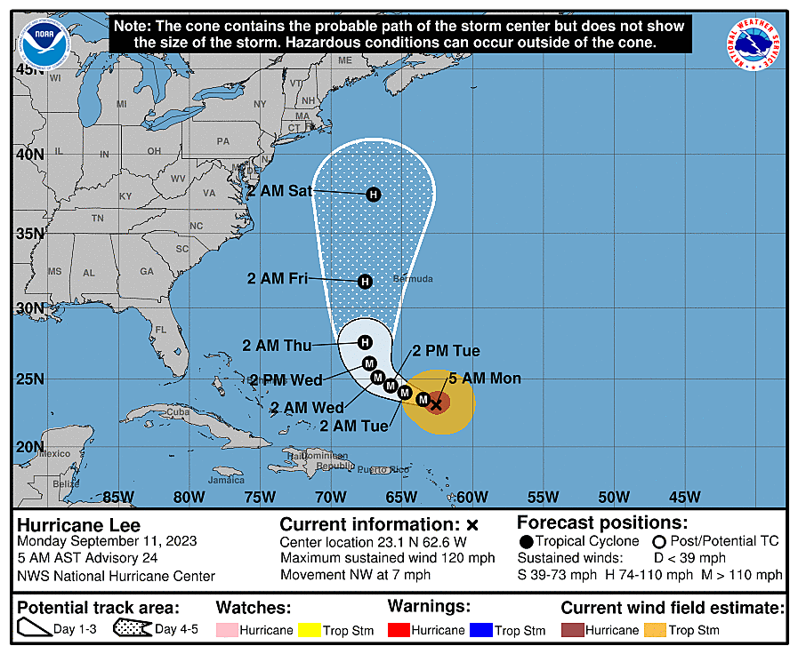
Let me preface this section by reiterating that there is still a lot of uncertainty in the Hurricane Lee forecast. We are about 96 to 120 hours away from potential impact, which is plenty of time for the storm track to "wiggle" and the impacts to shift.
As of Monday morning, Hurricane Lee is a category 3 major hurricane, with maximum sustained winds of 120 mph. The storm fell apart this weekend, due to excessive wind shear and fluctuating ocean temperatures. But it's still a very strong, dangerous hurricane, centered about 1,300 miles southeast of Cape May, N.J.
Lee's center is forecast to pass 200 to 400 miles east of New Jersey early Saturday morning. (The storm's forward motion has slowed down a bit.) That means, for New Jersey on the western edge of the storm, Lee's coastal impacts will far outweigh any potential weather impacts.
Weather-wise, we will probably feel breezy to windy conditions from Friday into Saturday, with potential gusts to 25 mph. (Not even close to tropical storm or hurricane strength, by the way.) Skies may become cloudy during that time frame, especially along the coast. And I would not rule out some drizzle blowing ashore, although there is a good chance that Lee raindrops do not even reach New Jersey.
As for coastal impacts, wave heights along the Jersey Shore are expected to grow to about 8 to 12 feet. That's huge enough to cause moderate to major beach erosion. Needless to say, an elevated risk of rip currents and dangerous surf conditions will be in play. In fact, Monday's rip current risk has already increased to Moderate. It should soar into the "High" category for the rest of the week.
The one big piece of the puzzle missing at this point is the magnitude of the storm surge and the severity of coastal flooding along NJ's tidal waterways. I can not hazard a guess at flooding numbers at this time, because the surge will be highly dependent on the exact strength, position, and orientation of the storm. That is why our tidal guidance only runs 72 hours into the future.
By late Tuesday, we should get a better idea of how loudly we will have to ring coastal flooding alarm bells, and whether any action steps are needed.
By the way, the worst impacts from Hurricane Lee will be felt northeast of New Jersey. Historic storm surge and wave heights (20+ feet?) are possible from Cape Cod, Massachusetts to Nova Scotia, Canada. And that area could be clipped by Lee's rain and wind shield too.
The bottom line: It is important to take Hurricane Lee's potential coastal impacts seriously. Residents along the Jersey Shore should monitor the forecast closely as the week goes on.
As always, I will do my best to present a realistic, hype-free version of this critical forecast, with regular updates as they become available and relevant.
Your hurricane emergency kit: what to pack
Dan Zarrow is Chief Meteorologist for Townsquare Media New Jersey. Follow him on Facebook for the latest forecast and realtime weather updates.
25 costliest hurricanes of all time
More From 92.7 WOBM