
Winter Storm Watch for Sunday: 6″ of snow likely across NJ, 12+” possible
UPDATE... This article is outdated...
For the latest winter storm forecast information, please refer to my newest weather blog post.
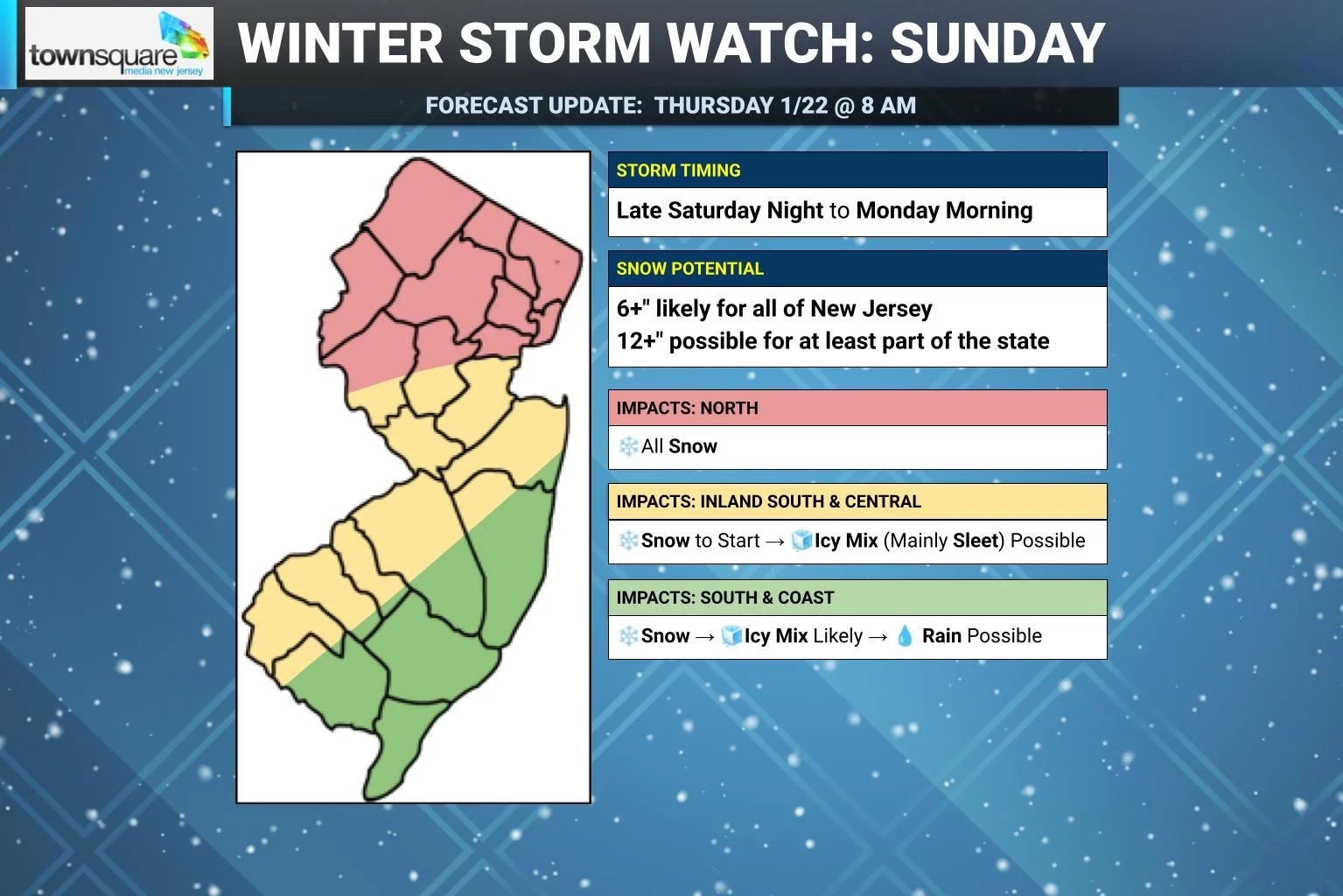
Well, it seems everybody is talking about Sunday's snow storm now. And with good reason! A Winter Storm Watch has now been issued for a majority of New Jersey — that is a formal heads up that heavy snow and ice accumulations will cause significant travel disruptions. It is time to consider your Sunday and Monday morning plans very carefully. In terms of the snow total forecast, I am still waffling over how icy mix will play into things, especially around southern and coastal New Jersey. The bottom line: Over 6 inches of snow accumulation is likely statewide, which already qualifies as a "major" winter storm. Over a foot is possible for at least part of the state.
Before the storm, we will enjoy the warmest day of the week on Thursday. Then a brisk wind will force temperatures downward on Friday. Saturday will be brutally cold, before snow moves in late Saturday night throughout the day on Sunday. Lingering wintry impacts are likely on Monday too.

Thursday: A Nice January Day
What a difference a day makes! This time on Wednesday morning, temperatures were in the single digits across most of New Jersey. Thursday morning, 30s and 40s. Much more reasonable and much more comfortable.
We have reached the warmest day of the week. That means, of course, temperatures are set to tumble again on Friday — so let's soak up the relative warmth while it lasts.
Highs on Thursday will reach the mid 40s or so. Some models even push out a few 50s in South Jersey. We will enjoy a pleasant mix of sun and clouds, and dry weather from start to finish.
Thursday night will stay quiet and partly cloudy. Lows will dip into the seasonably chilly mid 20s by Friday morning.
Friday: Changes Underway
Here comes our next cold front. It will be dry, but very noticeable.
High temperatures on Friday will only reach the mid 30s, already 10 degrees colder than Thursday. Plus, as a brisk northwesterly wind kicks up Friday afternoon, the wind chill will probably nosedive from the 20s to the teens. So we will definitely be back to bundling up by Friday evening.
Expect increasing clouds alongside those wind gusts to about 30 mph Friday. Again, I do not anticipate any rain or snow with the frontal passage.
Saturday: Back to the Arctic
Saturday looks like the coldest day of the week — which is nuts, because we have already braved some truly frigid weather so far.
Morning lows in the single digits. Afternoon highs only in the upper teens. (Maybe 20 degrees.) Wind chills no higher than the single digits, with a bitter arctic breeze.
And skies will be mostly cloudy to overcast, so you won't even get much (if any) golden sunshine to warm you up. What a dreadfully, ridiculously cold winter day.
At least the daytime hours Saturday will be dry and snowflake free. Snow could begin to arrive as early as 10 p.m. or Midnight Saturday night ahead of our winter storm.
Sunday: Winter Storm Watch
Get to the point: How much snow is going to fall in my backyard?
You know we have to play this very cautiously and slowly. I am still not comfortable or confident enough to publicly pinpoint exact snow accumulation numbers across New Jersey. But we are getting closer.
I will say this. Over six inches of snow accumulation is likely for all of New Jersey on Sunday. That already qualifies as a "major" winter storm in my book. Additionally, over a foot of snow is possible for at least part of New Jersey on Sunday. That's a lot of snow.
When will the snow start?
First flakes could arrive along the southern edge of New Jersey around Midnight Sunday morning, spreading statewide by daybreak. Bands of moderate to heavy snow will pick up throughout the day.
When will it get really bad?
I still can not pinpoint the exact timing of the "brunt" of the storm, as different forecast models still play out different scenarios of when the heaviest snow banding will occur — morning vs. afternoon vs. evening. I think it is safe to say conditions will be pretty wintry and pretty messy all day.
When will it end?
Snow should taper eventually Sunday evening. Having said that, light snow may linger into Monday morning as the storm system departs, especially for areas to the north and east.
What about this transition to icy mix and rain?
This type of storm track — a "Miller Type B Nor'easter" — carries warm air from the ocean and can transport it over land. This can happen both at the surface and just above the surface. The result during the storm is a transition from straight snow to an icy mix of mainly sleet. And, if surface temperatures climb above the freezing mark, possibly a flip to rain.
I have delineated on my initial storm impacts map the areas which I think will see icy mix and rain during the course of this storm. It is important to note that ALL of New Jersey will see snow to start. Heavy snow, in fact. That is why I insist that ALL of New Jersey will likely see "major" category snowfall of 6+ inches.
Once a transition to icy mix and/or rain happens, accumulations will slow down and/or stop. Sleet (ice pellets) does not accumulate the same way that snow does. Rain will only serve to make the snow on the ground slushy, wet, and heavy.
The biggest concern here is whether sleet and freezing rain could cause ice accumulation to occur on trees and power lines. Ice is very heavy, and this would be a potentially dangerous situation leading to tree damage and power outages. At the moment, true "ice storm" conditions are forecast to stay well south of New Jersey. But this is something we will have to continue to monitor closely.
What is a Winter Storm Watch?
A Winter Storm Watch was issued early Thursday morning for 16 of New Jersey's 21 counties, in effect from late Saturday night through Monday morning. The 5 counties in the northeast corner of the state were only left out due to a timing technicality — they will almost certainly be added to the watch in the next National Weather Service update cycle.
A watch serves as a formal heads up that heavy snow and ice accumulation will lead to significant travel disruptions. In New Jersey, a watch (and subsequent warning) are triggered when 5 to 6 inches of snow are in the forecast.
It is time to start thinking about your Sunday and Monday morning plans very carefully.
Will this be a blizzard?
No. A blizzard has a very specific definition, requiring 1.) strong winds and 2.) low visibility for 3.) an extended period of time. Winds will not be strong enough, although visibility could be low during periods of heavy snow on Sunday.
What will be the main impacts to worry about from this storm?
In general, the vast majority of winter storm injuries and deaths occur from motor vehicle accidents. If you can hunker down and stay off the roads, you will probably stay safe.
There could be sporadic power outages around, especially if the icing scenario plays out.
I am happy to say that I do not see a storm surge or coastal flooding threat given this storm's trajectory.
Airport delays and cancellations are practically a certainty.
Schools, churches, and businesses may decide to close too.
When will we know more?
We are almost in the 48-to-72 hour golden window when the fog clears and we start to get a good idea of how a storm will play out. I am planning on a special Thursday evening update of the CMDZ weather blog to publish a first call snow map, if it is warranted. Keep an eye on social media or download the New Jersey 101.5 mobile app for an instant alert when the post is published.
Monday: Lingering Wintry Impacts
There are some model solutions that keep light snow over parts of New Jersey (especially north and east) through Monday morning and midday. There could even be an additional couple inches of accumulation until things taper off for good.
At the very least, if the biggest snow and ice accumulation forecasts pan out, it will take a long time for crews to fully clear the roads. Keep a close eye on our Winter Weather Alert page for school closings and delayed openings on Monday morning — I suspect we will have many, many reported across the state.
Clouds will linger for a bit Monday, although we might catch some late-day glimmers of sun. It will stay cold — below-freezing, in fact — limiting the amount of snow and ice melt. Highs will be stuck in the 20s.
And we stay cold for the foreseeable future. Long-range model guidance shows no foreseeable warmup through the first several days of February. It is conceivable that much of New Jersey stays below freezing continuously through that period too — a week and a half to two weeks in the freezer.
Finally, and I hate to say it, but forecast models have sporadically put a storm system signal in the forecast for next weekend. That's Saturday the 31st to Sunday the 1st. That's way off in the distance, so no guarantees whatsoever. Just the next thing to watch.
Let it snow: 12 things to know about winter forecasting in NJ
Gallery Credit: Dan Zarrow
Dan Zarrow is Chief Meteorologist for Townsquare Media New Jersey. Follow him on Facebook for the latest forecast and realtime weather updates.
Dan Zarrow's Top 10 Weather and Climate Stories of 2025
Gallery Credit: Dan Zarrow
More From 92.7 WOBM


