Another nasty Sunday-Monday storm for NJ: 2-4″ rain, 50+ mph gusts
The Bottom Line
It's almost a 'deja vu' forecast to close out this weekend, as a powerful coastal storm aims to soak New Jersey once again. Rain arrives Sunday, peaks with strong winds late Sunday night, and then wraps up by midday Monday.
To be completely honest, this storm looks wetter, windier, nastier, and more impactful than last weekend's storm. It almost has the look and feel (and will have the strength) of a tropical storm. Plus, since it is a coastal storm system, tidal flooding is a concern this time around too.
Let's run through the timeline and expected impacts, so you can plan accordingly. Monday morning's commute is going to be a rough one.

Timeline
—Sunday Morning... Just cloudy so far. And a bit breezy in spots, with an occasional wind gust over 20 mph. You will salvage several hours of dry weather to start Sunday.
—Sunday Afternoon... Spotty rain showers are possible starting around Noon Sunday. (Note: All wet, nothing wintry, with temperatures well in the 50s.) There could be some pockets of heavier stuff, but it will be hit-or-miss to start.
—Sunday Evening to Monday Morning... After about 4 or 5 p.m. Sunday, steady rain will envelop New Jersey. After about 9 or 10 p.m. Sunday, we enter the "brunt" of the storm, with a period of torrential rain and powerful winds overnight. The worst weather probably will not subside until mid-morning Monday - about 9 or 10 a.m. So the morning commute will be heavily impacted by weather.
—Mid to Late Monday Morning... As the heaviest storm bands move off-shore, New Jersey's weather will calm. We still face some spotty rain showers around through about midday Monday. Temperatures will start to slide backward too, but there is no threat of a transition to wintry weather.
—Monday Afternoon... Rain wraps up, and blue sky may very well emerge just before sunset. Still breezy. And temperatures will continue to drop through Monday night.
Impacts
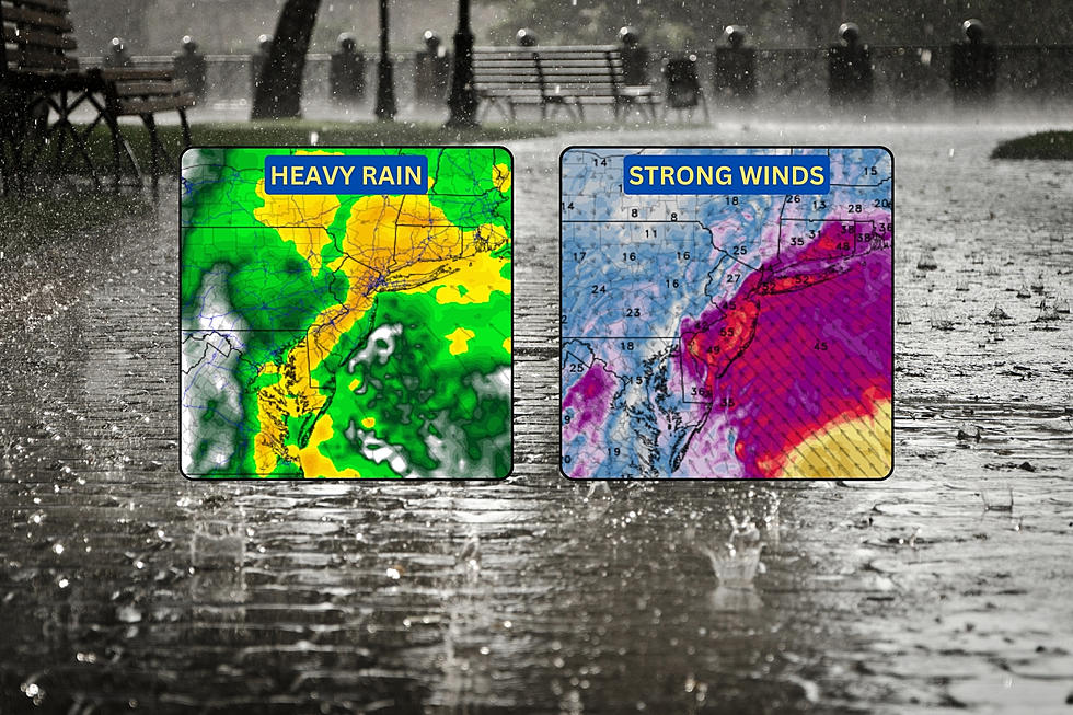
—Rain... Once again, the clear biggest concern for this storm. Rainfall estimates have gone up over the last day, now reaching 2 to 4 inches across New Jersey. I am probably leaning toward the lower end of that range, but the threat of downpours and deluges warrants the possibility of 3 or 4 inches of total rainfall. Exact totals will depend on where the heaviest rain bands set up. Ponding and flooding is inevitable. If you don't have to drive late Sunday night into early Monday morning, it would be a good idea to just stay put. A Flood Watch has been issued for all 21 counties of New Jersey from Sunday evening through Monday afternoon.
—Wind... Top wind gusts early Monday morning are expected to fall in the 40 to 60 mph range. The strong winds will likely be felt along the immediate coast. (Although bands of heavy rain and thunderstorms may push out some fierce winds too.) That is enough to exacerbate visibility and driving difficulties. It also puts branches in danger of coming down, potentially causing scattered power outages. Take time now to secure holiday decorations, garbage cans, etc. A Wind Advisory covers the immediate coast from 8 p.m. Sunday to 7 a.m. Monday.
—Coastal Flooding... Those strong winds are easterly - blowing from an on-shore direction. Therefore, we are subject to an extra push of ocean water, which we call storm surge. And that leads to coastal flooding. Three high tide cycles could exceed flood stage: Monday late morning, Monday late evening, and (the highest crest) Tuesday midday. Some areas could flirt with the moderate flooding category. Be prepared for road closures and detours for several hours surrounding high tide. A Coastal Flood Watch is out for Hudson, eastern Bergen, eastern Essex, and eastern Union counties. A Coastal Flood Advisory has been posted for Middlesex, Monmouth, Ocean, southeastern Burlington, Atlantic, and Cape May counties.
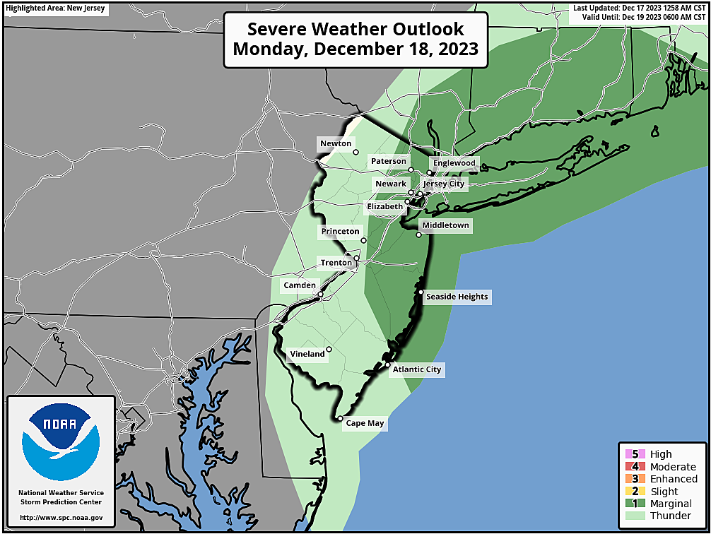
—Severe Thunderstorms... This storm system is going to be very strong and very dynamic. In such an atmosphere, embedded thunderstorms may produce their own severe weather. Strong wind gusts and occasional cloud-to-ground lightning would be the big concerns. But a quick spin-up tornado or two can't be ruled out either. The greatest risk for such thunderstorms would be toward the end of the storm, early Monday morning.
—Cooldown... Temperatures will drop on Monday, from a morning high near 60 degrees, potentially into the 40s by sunset. It's not an "arctic blast". And temperatures will not get cold enough to force a transition from rain to snow (or any other wintry precipitation type). While you may not need a jacket Monday morning, be prepared for the day to end blustery and colder.
—Wintry Weather... Nope.
What's Next?
On the far western edge of this storm's circulation, a few isolated showers may slide through New Jersey early Tuesday morning. And with temperatures close to the freezing mark, a quick hit of snow is possible. A few model runs have hinted at light accumulations, especially to the northwest. Just something we will have to watch to potentially impact the Tuesday morning commute.
After that, we settle into another period of quiet, seasonable weather. Both Wednesday and Thursday will be mostly sunny, with highs in the 40s.
Of course, this is a very busy traveling week, with Christmas now a week away. And I do not see any problems, as New Jersey likely stays storm-free through next weekend. Sorry to say, that negates the possibility of a White Christmas too.
Long-range forecast models hint at a few storm system signals between Christmas and New Year's. Way too early for details, but we will have to watch for an active, stormier pattern to close out 2023 and ring in 2024.
Be safe out there before, during, and after this powerful coastal storm. As always, we will have regular updates on-air and online until the final raindrops fall.
Glossary of NJ winter weather words and phrases
Gallery Credit: Dan Zarrow
Dan Zarrow is Chief Meteorologist for Townsquare Media New Jersey. Follow him on Facebook for the latest forecast and realtime weather updates.
Christmas snow - When it's happened, and the 2023 odds for NJ
Gallery Credit: Mike Brant
More From 92.7 WOBM