‘Isaias day’ for NJ — 70+ mph wind gusts, bands of heavy rain
Overview
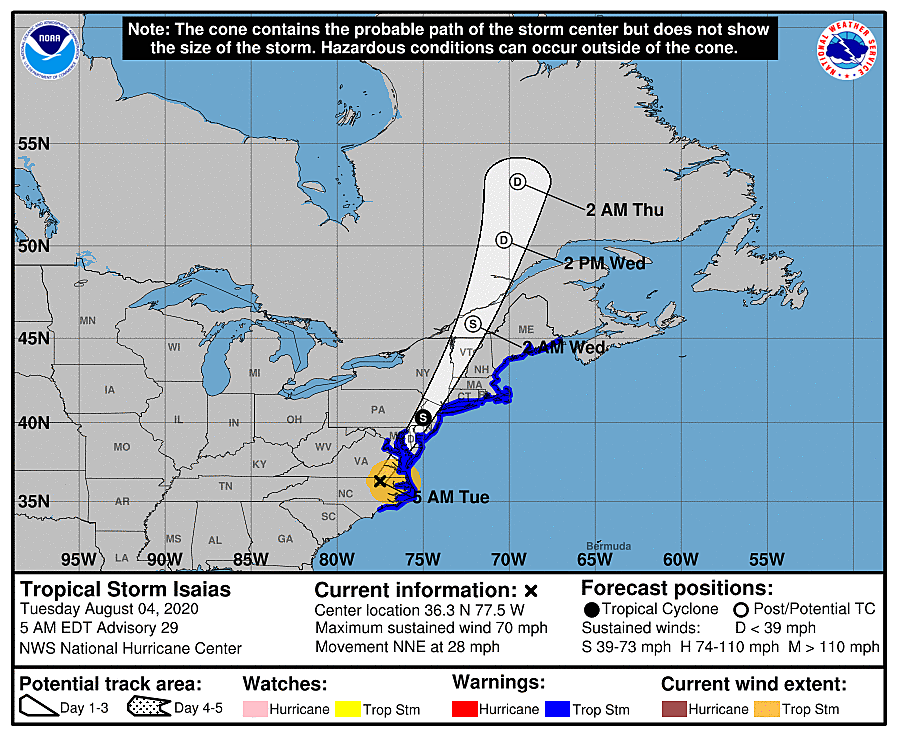
Isaias made landfall on the North Carolina coast as a hurricane late Monday night. Since then, it has weakened over land, and was downgraded to a tropical storm with 70 mph sustained winds as of 5 a.m. Tuesday.

And we are expecting tropical storm conditions throughout the entire state Tuesday:
—Wind is absolutely concern #1. Downed trees may block travel and cause widespread power outages.
—Heavy rain is likely too (and already occurring in spots, as of this writing). Pockets of flash and river flooding are likely during the height of the storm.
—A few tornadoes can't be ruled out, especially to the south.
—We'll be watching the coast for big waves and tidal flooding too.
The storm will peak here in New Jersey during the daytime hours Tuesday. As the center of Tropical Storm Isaias passes over the state and departs, you'll know immediately. Winds will calm and skies will clear rapidly — you might see sunshine by the time it sets this evening.
I believe the best information I can present on this "tropical storm day" is a county-by-county timeline and impacts estimate. As you review the detailed forecast I've put together here, please "blur your eyes" a little bit — everything is a back-of-the-envelope approximation. Hopefully it's enough information so you can plan your day.
Atlantic County
—Advisories... Tropical Storm Warning, Flash Flood Watch (until Midnight), High Surf Advisory (8 a.m. to Midnight), Coastal Flood Advisory (11 a.m. Tuesday to 2 a.m. Wednesday)
—The Peak of the Storm... 10 a.m. to 4 p.m.
—Top Wind Gusts... 70+ mph
—Total Rainfall... 1/2 to 1 inch
—Storm Surge... 1 to 2 feet, causing minor to localized moderate flooding of tidal waterways (especially in back bays)
—Wave Height... 8 to 12 feet
—Severe Weather Risk... A few tornadoes possible
Bergen County
—Advisories... Tropical Storm Warning, Flash Flood Watch (until 6 a.m.)
—The Peak of the Storm... 2 p.m. to 7 p.m.
—Top Wind Gusts... 70+ mph
—Total Rainfall... 1/2 to 1 inch
—Severe Weather Risk... Isolated tornado possible
Burlington County
—Advisories... Tropical Storm Warning, Flash Flood Watch (until Midnight), Coastal Flood Advisory (11 a.m . to 8 p.m.)
—The Peak of the Storm... 11 a.m. to 5 p.m.
—Top Wind Gusts... 60+ mph
—Total Rainfall... 1 inch
—Storm Surge... up to 1 foot, causing minor flooding of tidal waterways
—Wave Height... 8 to 12 feet
—Severe Weather Risk... A few tornadoes possible
Camden County
—Advisories... Tropical Storm Warning, Flash Flood Watch (until Midnight), Coastal Flood Advisory (11 a.m. to 8 p.m.)
—The Peak of the Storm... 10 a.m. to 4 p.m.
—Top Wind Gusts... 60+ mph
—Total Rainfall... 2 inches
—Storm Surge... up to 1 foot, causing minor flooding of tidal waterways
—Severe Weather Risk... A few tornadoes possible
Cape May County
—Advisories... Tropical Storm Warning, Tornado Watch (until Noon), Flash Flood Watch (until Midnight), High Surf Advisory (8 a.m. to Midnight), Coastal Flood Advisory (8 a.m. to 8 p.m.)
—The Peak of the Storm... 9 a.m. to 4 p.m.
—Top Wind Gusts... 70+ mph
—Total Rainfall... 1/2 to 1 inch
—Storm Surge... 1 to 2 feet, causing minor to localized moderate flooding of tidal waterways (especially in back bays)
—Wave Height... 8 to 12 feet
—Severe Weather Risk... A few tornadoes possible
Cumberland County
—Advisories... Tropical Storm Warning, Tornado Watch (until Noon), Flash Flood Watch (until Midnight), Coastal Flood Advisory (8 a.m. to 8 p.m.)
—The Peak of the Storm... 9 a.m. to 3 p.m.
—Top Wind Gusts... 70+ mph
—Total Rainfall... 1 inch
—Storm Surge... about 1 foot, causing minor to localized moderate flooding of tidal waterways
—Wave Height... 8 to 12 feet
—Severe Weather Risk... A few tornadoes possible
Essex County
—Advisories... Tropical Storm Warning, Flash Flood Watch (until 6 a.m.), Coastal Flood Warning (8 p.m. to 1 a.m.)
—The Peak of the Storm... 1 p.m. to 7 p.m.
—Top Wind Gusts... 60+ mph
—Total Rainfall... 1 inch
—Storm Surge... about 1 foot, causing minor to localized moderate flooding of tidal waterways
—Severe Weather Risk... Isolated tornado possible
Gloucester County
—Advisories... Tropical Storm Warning, Flash Flood Watch (until Midnight), Coastal Flood Advisory (11 a.m. to 8 p.m.)
—The Peak of the Storm... 10 a.m. to 4 p.m.
—Top Wind Gusts... 60+ mph
—Total Rainfall... 2 inches
—Storm Surge... up to 1 foot, causing minor flooding of tidal waterways
—Severe Weather Risk... A few tornadoes possible
Hudson County
—Advisories... Tropical Storm Warning, Flash Flood Watch (until 6 a.m.), Coastal Flood Warning (8 p.m. to 1 a.m.)
—The Peak of the Storm... 2 p.m. to 7 p.m.
—Top Wind Gusts... 60+ mph
—Total Rainfall... 1 inch
—Storm Surge... about 1 foot, causing minor to localized moderate flooding of tidal waterways
—Severe Weather Risk... Isolated tornado possible
Hunterdon County
—Advisories... Tropical Storm Warning, Flash Flood Watch (until Midnight)
—The Peak of the Storm... 12 p.m. to 6 p.m.
—Top Wind Gusts... 50+ mph
—Total Rainfall... 3 inches
—Severe Weather Risk... Isolated tornado possible
Mercer County
—Advisories... Tropical Storm Warning, Flash Flood Watch (until Midnight)
—The Peak of the Storm... 11 a.m. to 6 p.m.
—Top Wind Gusts... 50+ mph
—Total Rainfall... 2 inches
—Severe Weather Risk... Isolated tornado possible
Middlesex County
—Advisories... Tropical Storm Warning, Flash Flood Watch (until Midnight), Coastal Flood Advisory (11 a.m. Tuesday to 2 a.m. Wednesday)
—The Peak of the Storm... 12 p.m. to 6 p.m.
—Top Wind Gusts... 60+ mph
—Total Rainfall... 1 inch
—Storm Surge... about 1 foot, causing minor to localized moderate flooding of tidal waterways (especially in back bays)
—Wave Height... 8 to 12 feet
—Severe Weather Risk... Isolated tornado possible
Monmouth County
—Advisories... Tropical Storm Warning, Flash Flood Watch (until Midnight), High Surf Advisory (8 a.m. to Midnight), Coastal Flood Advisory (11 a.m. Tuesday to 2 a.m. Wednesday)
—The Peak of the Storm... 11 a.m. to 6 p.m.
—Top Wind Gusts... 70+ mph
—Total Rainfall... 1/2 to 1 inch
—Storm Surge... 1 to 2 feet, causing minor to localized moderate flooding of tidal waterways (especially in back bays)
—Wave Height... 8 to 12 feet
—Severe Weather Risk... Isolated tornado possible
Morris County
—Advisories... Tropical Storm Warning, Flash Flood Watch (until Midnight)
—The Peak of the Storm... 1 p.m. to 7 p.m.
—Top Wind Gusts... 50+ mph
—Total Rainfall... 1 inch
—Severe Weather Risk... Isolated tornado possible
Ocean County
—Advisories... Tropical Storm Warning, Flash Flood Watch (until Midnight), High Surf Advisory (8 a.m. to Midnight), Coastal Flood Advisory (11 a.m. Tuesday to 2 a.m. Wednesday)
—The Peak of the Storm... 11 a.m. to 5 p.m.
—Top Wind Gusts... 70+ mph
—Total Rainfall... 1/2 to 1 inch
—Storm Surge... 1 to 2 feet, causing minor to localized moderate flooding of tidal waterways (especially in back bays)
—Wave Height... 8 to 12 feet
—Severe Weather Risk... A few tornadoes possible
Passaic County
—Advisories... Tropical Storm Warning, Flash Flood Watch (until 6 a.m.)
—The Peak of the Storm... 2 p.m. to 7 p.m.
—Top Wind Gusts... 50+ mph
—Total Rainfall... 1 inch
—Severe Weather Risk... Isolated tornado possible
Salem County
—Advisories... Tropical Storm Warning, Tornado Watch (until Noon), Flash Flood Watch (until Midnight), Coastal Flood Advisory (8 a.m. to 8 p.m.)
—The Peak of the Storm... 10 a.m. to 3 p.m.
—Top Wind Gusts... 70+ mph
—Total Rainfall... 2 inches
—Storm Surge... about 1 foot, causing minor to localized moderate flooding of tidal waterways
—Wave Height... 8 to 12 feet
—Severe Weather Risk... A few tornadoes possible
Somerset County
—Advisories... Tropical Storm Warning, Flash Flood Watch (until Midnight)
—The Peak of the Storm... 12 p.m. to 6 p.m.
—Top Wind Gusts... 50+ mph
—Total Rainfall... 1 inch
—Severe Weather Risk... Isolated tornado possible
Sussex County
—Advisories... Tropical Storm Warning, Flash Flood Watch (until Midnight)
—The Peak of the Storm... 1 p.m. to 7 p.m.
—Top Wind Gusts... 50+ mph
—Total Rainfall... 3 inches
—Severe Weather Risk... Isolated tornado possible
Union County
—Advisories... Tropical Storm Warning, Flash Flood Watch (until 6 a.m.), Coastal Flood Warning (8 p.m. to 1 a.m.)
—The Peak of the Storm... 1 p.m. to 6 p.m.
—Top Wind Gusts... 60+ mph
—Total Rainfall... 1 inch
—Storm Surge... about 1 foot, causing minor to localized moderate flooding of tidal waterways
—Severe Weather Risk... Isolated tornado possible
Warren County
—Advisories... Tropical Storm Warning, Flash Flood Watch (until Midnight)
—The Peak of the Storm... 12 p.m. to 6 p.m.
—Top Wind Gusts... 50+ mph
—Total Rainfall... 3 inches
—Severe Weather Risk... Isolated tornado possible
The Final Word
For the second time in 25 days, New Jersey is directly getting smacked by a tropical storm. Making such a statement is really surreal.
It is going to be a nasty day. And potentially dangerous, especially given the intense wind gust. And the burst of rain would be great either. You really don't want to be "out and about" during the brunt of the storm. Please stay smart and be safe out there.
After Isaias exits, we have a beautiful summer day in the forecast tomorrow. But we have to get there first.
We're on-air all day with your latest weather, traffic, news, and storm talk. See you on the other side, New Jersey.
Dan Zarrow is Chief Meteorologist for Townsquare Media New Jersey. Follow him on Facebook or Twitter for the latest forecast and realtime weather updates.
More From 92.7 WOBM