A wintry weekend for NJ: Saturday’s snow on track, Sunday’s trends higher
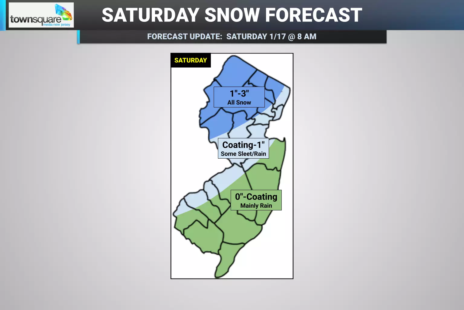
Saturday's Storm
The Bottom Line... Welcome to the weekend, New Jersey! As our weather turns inclement, wet and/or wintry, your outdoor and travel plans may be affected on Saturday by a clipper system moving in from the west, expected to bring widespread precipitation across New Jersey. Conditions will vary depending upon where in the state you are. Northern New Jersey will see up to a few inches of accumulating snow. The NJ Turnpike corridor will likely see slushy light snowfall. And farther south, with temperatures at or above 40 degrees, rain will limit accumulations and icy conditions.
Timing... As of this writing (8 a.m. Saturday), radar is already lighting up with snow and rain along the western edge of New Jersey. Our air is very dry at the moment, so it will take some time for that precipitation to fill in across the state Saturday morning. Temperatures currently range from 23 degrees to the north to 42 degrees to the south, with the freezing line running approximately between Trenton and New Brunswick. The steadiest heaviest snow/rain will likely come around the midday hours Saturday, between about 10 a.m. and 3 p.m. Things should wrap up quickly around sunset, by 5 or 6 p.m.
Accumulations... Where the heaviest precipitation bands meet the coldest temperatures in northwestern New Jersey, about 3 inches of snow accumulation is expected. That is enough to cause problems on roads (especially untreated ones), and enough to have to shovel and plow. Farther south, where snow is lighter and/or rain mixes in, a slushy inch or so is expected on the ground along the Turnpike corridor. For southern and coastal New Jersey, little to no accumulation is expected from Saturday's storm.
Advisories... The National Weather Service continues a Winter Weather Advisory for four North Jersey counties until 4 p.m. Saturday: Sussex, Warren, Morris, and western Passaic. The advisory specifically calls for localized snow totals up to 5". Advisories are issued as a formal heads up for hazardous travel conditions due to snow and ice.
Impacts... It's not a major winter storm, but it will be a wintry, slippery day for a good chunk of New Jersey. Whether it turns wet or wintry where you are, be smart, be safe, and stay warm and dry out there.
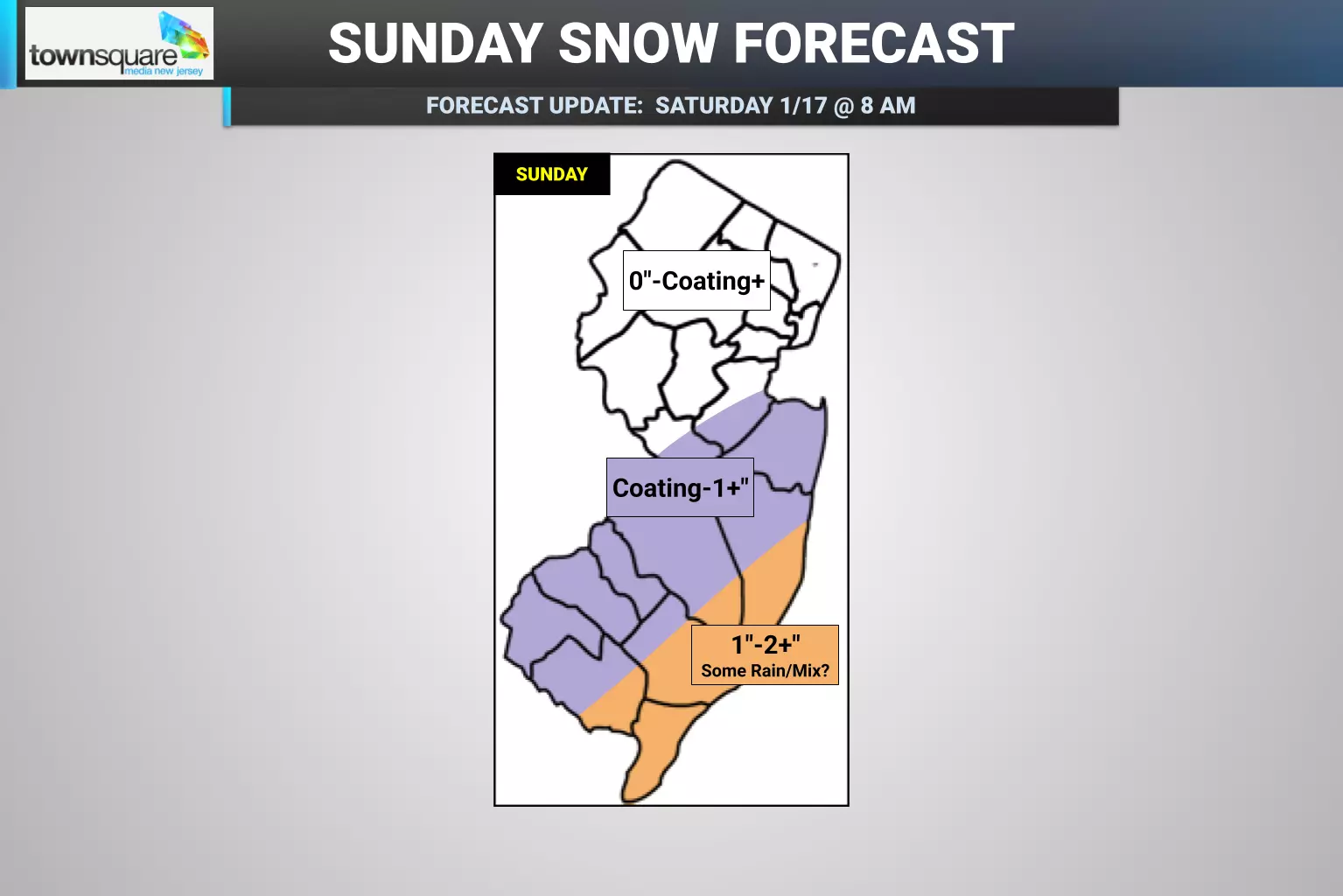
Sunday's Storm
The Bottom Line... New Jersey's next storm system arrives on Sunday, a piece of coastal energy that is still expected to stay mainly off-shore. However, some model guidance has taken a notable jog to the west — closer to New Jersey — raising eyebrows to the possibility of more widespread and heavier snowfall. It's not quite time to ring those alarm bells yet — it is foolish to drastically change a forecast based on one model run, and we still have a pretty significant storm system signal in the way (Saturday's) before we can deal with the next one (Sunday's). So we're still wading through uncertain waters here. I'm putting forth what I think is a "most likely" forecast scenario. But please keep in mind there is a higher snow scenario (denoted by the "plus" symbols on my forecast map). And also a "nothing at all" solution on the table too, if this thing takes a wide right turn out too.
Timing... Sunday's storm would potentially be an all-day affair, with snowflakes starting in New Jersey just before sunrise and ending just after sunset. While the timing of the heaviest, steadiest period of snow would be dependent on which storm track scenario plays out, I still suspect the afternoon will be the overall "brunt" of the storm. (That is relative, as we're not necessarily talking about heavy snow, wind, or whiteout conditions here.)
Accumulations... So my official "most likely" forecast still calls for an inch or two of snowfall along the central and southern Jersey Shore, with a dusting or coating farther inland. If that thinking plays out, North Jersey would see thick clouds but nothing new falling from them. Temperatures in Cape May County might be just above freezing, which means some rain might mix in there, limiting snowfall totals and creating more of a slushy mess. Overall though, the current forecast calls for a nice, light, minor snow event — conversational snow, if you will.
Worst Case Scenario... My intention here is not to hype the higher, more dramatic scenario. But I think it is important to point out the new western storm track would produce quite a bit more snow, for just about everyone in New Jersey. Along the lines of 2" to the north and west. And 6" south and coast. Much more impactful and serious.
Advisories... No warnings or advisories have been issued for Sunday's storm yet. If the current forecast holds, I don't expect any. If forecast snow totals have to increase, then we probably will see some alerts and alarm bells by late Saturday. (And I will update my weather blog, social media, and on-air forecasts accordingly.)
Impacts... As always, winter storms are all about sloppy travel. Even an inch or two can make for slippery driving and walking conditions. We may or may not have a shovelable or plowable storm here, depending on exact totals.
Coming Up Next: Potentially Dangerous Cold
The snow that falls and accumulates this weekend will be here for a while, as temperatures stay in the freezer for the foreseeable future.
Monday's high temperatures will only reach about the freezing mark, in the lower 30s. It will be a sunny day, with a biting breeze. Bundle up, buttercups — it is the "dead of winter," after all.
Another blast of arctic air is set to arrive Monday night into Tuesday. Yes, that means it is going to get even colder.
Both Tuesday morning and Wednesday morning will see widespread temperatures in the teens, with some single digits around. When the wind blows, the wind chill (the "feels like" or "apparent" temperature) will dip to around zero. That is the threshold for "dangerous cold," when conditions outside become dangerous to human health after an extended period of exposure. Frostbite and hypothermia become increased concerns. Sorry not sorry for taking this so seriously — you really have to take care of yourself in such conditions.
Highs on Tuesday will only be in the 20s. Wednesday should reach back into the 30s.
I believe cold, snowy weather will be the theme throughout the final third of January, with several storm signals showing up in long-range forecasts. Hold on tight, there are still 62 days of winter left to go...
The best NJ foods and soups for cold, snowy weather
Gallery Credit: Mike Brant
Dan Zarrow is Chief Meteorologist for Townsquare Media New Jersey. Follow him on Facebook for the latest forecast and realtime weather updates.
Glossary of NJ winter weather words and phrases
Gallery Credit: Dan Zarrow
More From 92.7 WOBM