Yes, it might snow this weekend in New Jersey
No, it's not going to be a big deal. It will, however, be a very un-springlike weekend with chilly temperatures, a messy mix of rain and snow, and a brisk wind.
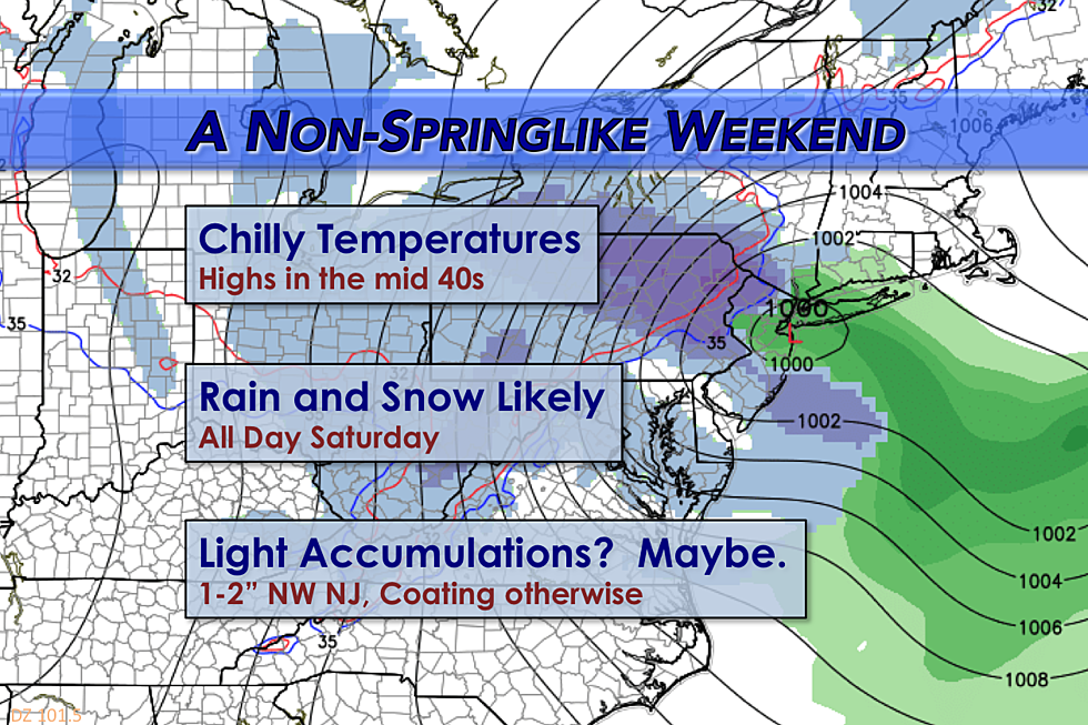
Spring? April? Ha! Another cooldown is on the way for the upcoming weekend. And, as a storm system passes right over New Jersey on Saturday, we do have some rain and snow in the forecast too.
Fairly Quiet Friday
Let's start with Friday, which actually looks like a halfway-decent day. Morning temperatures are mostly in the 40s. High temperatures are forecast to reach the mid 50s, just a few degrees shy of normal for early April. An occasionally brisk wind is expected too, up to 20 or 25 mph. And I can't rule out an isolated shower or sprinkle. At times, there will be more sun than clouds. At other times, clouds will win the sky. Again, New Jersey has seen nicer days and we've certainly seen worse.
Overnight will be mostly quiet, with partly cloudy skies and lows on either side of the freezing mark in the lower to mid 30s.
Chilly, Slightly Snowy Saturday
Our weather picture becomes tricky and potentially wintry starting around sunrise Saturday. The bottom line is that a storm system will pass right across New Jersey throughout the day Saturday.
Will it be rain, or will it be snow? Probably both. Here's a rundown of what to expect from this potential late-season taste of winter:
TIMING? Precipitation is expected to start in the southwest corner of New Jersey around 5 a.m. Saturday, spreading northward by mid-morning. The precipitation could continue for at least part of New Jersey through about Midnight Saturday night.
TEMPERATURES? Saturday morning lows will be in the lower to mid 30s. Saturday afternoon highs will be in the mid 40s. Saturday night's low temperatures will fall into the 20s across the entire state.
RAIN OR SNOW? As usual, precipitation type will be dictated by storm system timing and exact temperatures (not just at the surface, but throughout the lowest mile of the atmosphere). I believe the first bands of precipitation will come as snow or a snow/rain mix. As temperatures warm into the 40s from Saturday mid-morning through Saturday late afternoon, we'll likely transition to all rain (except, perhaps, in far North Jersey). Then, as Saturday evening comes along, temperatures will drop to the freezing mark again. If the timing of this period of subfreezing temperatures matches up with a heavier band of precipitation, we could see some snow accumulation by early Sunday morning.
BIG SNOW TOTALS? Models and armchair meteorologists have been promoting some crazy snowfall totals from this system (6+ inches?! 9+ inches?!) But it's just not going to happen. Late-season snow accumulation in New Jersey is difficult (although not impossible). Soil temperatures are in the mid 40s right now. And when the ground becomes wet from rain on Saturday afternoon, it will be even harder for the snow to "stick".
LIGHT ACCUMULATIONS? We might see upwards of an inch or two of snow accumulation in the higher elevations of northwestern New Jersey. And we might see a coating of snow across the rest of the state (especially away from the coast). Most, if not all, snow accumulation will be on cold non-paved surfaces.
WARNINGS OR ADVISORIES? None have been issued at this time. (Aside from a Freeze Watch, but that doesn't count.) As long as this forecast holds, there should not be any significant travel problems on Saturday.
Sunday and Beyond
Sunday will remain chilly, with highs in the mid 40s at best. That's about 15 degrees below normal for early to mid April. We should, however, see some nice breaks of sunshine for the first 3/4 of the day.
The forecast for next week is a bit in flux. Monday will be warmer than the weekend, and South Jersey may actually make a run for 60 degrees. The rest of the state will be in the comfortable, almost-seasonable mid to upper 50s.
Another front will approach in the Monday night to Tuesday morning time frame. That will cause a drop in temperatures at some point on Tuesday. And we'll also see some precipitation. All rain this time.
One the biggest questions I've been getting lately... When will it warm up for good?! Well, the long-range forecast shows consistently warmer air arriving by the end of next weekend. So by Tax Day (April 18) at the latest, it looks like thermometers should reach 60+ degrees just about every day.
See Ya, Suckers!
After this volatile winter of tough forecasts, sneaky snow storms, and wild temperature swings, I need a vacation! So, I'm taking a week off! My family and I will be spending some time in sunny, warm Florida. We'll be visiting some of my wife's family. And baby Jackson will be visiting Disney World for the first time!
I'll check in occasionally, especially before and during Saturday's potential snow event. In my absence, the rest of our intrepid weather and news team will cover your forecast online and on-air. I will return to the weather world on Monday, April 18.
More From 92.7 WOBM


