Wintry transition from snow to ice to rain may slicken NJ roads
A few inches of snow and a trace of ice are expected in parts of North Jersey from late Sunday through early Monday.
Background
New Jersey will be clipped by a storm system Sunday afternoon through Monday morning, bringing a wide variety of potentially wintry weather to the Garden State. It will certainly be cold enough for all snow at the precipitation's onset Sunday (as afternoon temperatures barely reach the mid to upper 30s). But a gradual warmup overnight will lead to a complicated transition from all snow to sleet/freezing rain to all rain.
While snow accumulations are expected to remain light and this is not a major winter storm, the light icing threat could be a problem. It won't take much ice accretion to make for very slippery and difficult travel conditions.
Challenges
1.) Cold air is dry air. And our presently bone-dry atmosphere will limit how much precipitation is able to form and fall to the ground early Sunday.
2.) As I mentioned in Saturday's blog entry, the timing and speed of our eventual warmup Sunday night/Monday morning will be key in determining our weather impacts. Exactly when that transition happens and how heavy the precipitation is before and after transition time will directly impact how much snow and ice accumulates.
3.) Furthermore, freezing rain is always tricky to forecast accurately, as it requires a very specific temperature profile both in the air (above freezing) and on the ground (below freezing).
Winter Weather Advisory
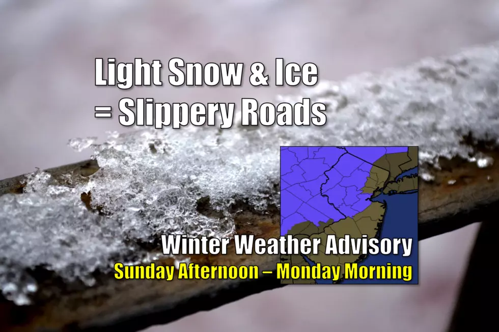
The National Weather Service has expanded their previous Winter Weather Advisory to now include Middlesex and Mercer counties, because of the freezing rain and icing threat. Here's the rundown of advisories as of Sunday morning:
--Sussex, Warren, Morris counties from 1 p.m. Sunday to 9 a.m. Monday, calling for 3 to 5 inches of snow and a trace of ice
--Western Passaic county from 4 p.m. Sunday to 10 a.m. Monday, calling for 2 to 5 inches of snow and a trace of ice
--Hunterdon and Somerset counties from 1 p.m. Sunday to 6 a.m. Monday, calling for 1 to 3 inches of snow and a trace of ice
--Middlesex and Mercer counties from 1 p.m. Sunday to 4 a.m. Monday, calling for up to 1 inch of snow and a trace of ice
For the record, almost all of New England and New York are also under a Winter Weather Advisory due to this storm.
Timeline
Again, this is the tricky aspect of this wintry forecast, and key to nailing down anticipated accumulations and conditions. I believe the forecast models have settled on a reasonable consensus. I also believe the NWS Winter Weather Advisory is appropriate and well-placed, not necessarily due to snow accumulation but because of the icing concern.
Here's how Sunday's and Monday's weather look to play out:
--Sunday Morning: Cold, but fairly quiet. There have been a few light snow showers and flurries on radar - especially in South Jersey. But nothing substantial yet.
--Sunday Afternoon: Snow showers will creep across the Delaware River into northwestern New Jersey between 11 a.m. and 7 p.m. The big time window is necessary here as dry air may initially limit precipitation from reaching the ground (see "Challenges" above). The ground will certainly be cold enough to sustain accumulating snow immediately.
--Sunday Evening: Light to occasionally moderate snow will continue to spread through the state, especially the northern half.
--Sunday Night: An influx of warmer air will cause a transition from snow to freezing rain to rain, around the 1 a.m. to 7 a.m. time frame. While the period of freezing rain will be brief, it could lead to a light glaze of ice on road surfaces and walkways. At least part of the state may be affected by slick roads for at least part of the morning commute.
--Monday Morning: Just about everyone in New Jersey will go to all rain by mid-morning Monday, at the latest. (The possible exception is around Sussex County, where subfreezing temperatures and snow could persist a bit longer.) Periods of steady rain are possible as the storm system wraps up. And it's going to be a cold, uncomfortable rain too.
--Monday Afternoon: All precipitation will taper off, from west to east, at some point on Monday. Some models show the rain to stop as early as 1 p.m. Some keep showers on top of the Garden State through about 7 p.m.
Accumulations/Impacts
3+ inches of snow is forecast to accumulate in the higher elevations around Sussex, Morris, and Passaic counties. That area of the state will be the first to experience snow on Sunday, and the last to transition to rain on Monday.
1+ inch of snow is expected along and north of Interstate 78. Keep in mind, snow totals will likely be limited in the urban corridor of NE NJ due to warmer temperatures and a warmer ground.
I'm going to say that a trace of snow is possible statewide from this system, not leaving anything to chance. But the best chance for snowflakes and for the ground whitening up for a bit will be in the northern half of NJ (above Interstate 195). In other words, for South Jersey, it'll probably be mostly rain.
Most importantly, a trace of ice will be possible in the Winter Weather Advisory area in northern and central New Jersey (see above). This would certainly be the biggest wintry impact, if it comes to fruition, as traction on roads and sidewalks could decrease to near-zero.
Action Steps/Insight
The potential impacts to travel due to snow and ice can't be ignored. However, once again, this ain't "the big one". It's just an advisory, not a warning. Stay informed throughout the storm and be extra careful on the roads Sunday night and Monday morning, and you'll be just fine.
We'll continue to bring you updates on this storm, both on-air and online, from first flakes to last drops. Stay warm and be safe!
More From 92.7 WOBM


