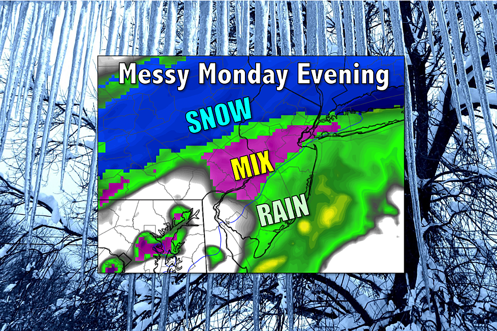
Snow to ice to rain: Tricky evening commute across NJ Monday
As of late Monday afternoon, it had been snowing steadily for several hours in central and southern New Jersey with more than an inch of accumulation in spots, but the iciest part of this winter storm still appeared yet to come.
Current Situation: Monday afternoon
It's been a snowy President's Day for much of New Jersey, with light to moderate snow covering many secondary roads, side streets, parking lots, and more. Hopefully the snow has given you an excuse to stay home and relax, if you were lucky enough to have the day off.
This storm system is nowhere near done — as of this writing, the main driver is well to our south and won't clear the Garden State until late Tuesday evening. We will, however, see a transition from wintry to wet for Monday evening.
Winter Weather Advisories continue:
--Until 10 p.m. for Atlantic, Burlington, Camden, Cape May, Cumberland, Gloucester, Mercer, Middlesex, Monmouth, Ocean, and Salem counties
--Until Midnight for Bergen, Essex, Hudson, E Passaic, and Union counties
--Until 1 a.m. for Hunterdon, Morris, Somerset, and Warren counties
--Until 4 a.m. for Sussex county
--Until 7 a.m. for W Passaic county
Thermometers ... Going Up!
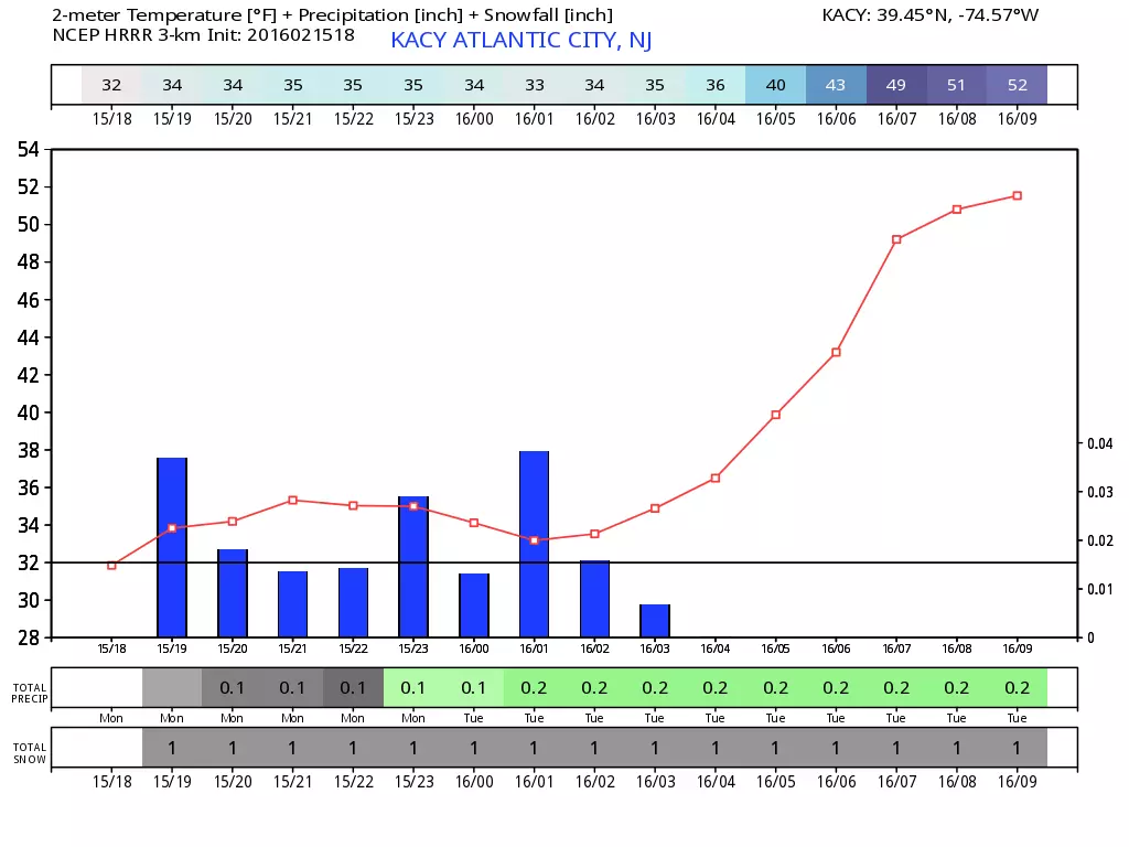
Temperatures will actually rise overnight, from the 20s on Monday afternoon to the 50s by Tuesday morning. Yes, almost "balmy" 50s!
As this storm system continues to press through New Jersey, warmer temperatures at all layers of the atmosphere will cause a transition from snow to rain everywhere in New Jersey by Tuesday morning. Within this transition period, however, conditions may be perfect for a period of freezing rain, probably the most dangerous and most slippery kind of winter precipitation. And, as usual, Mother Nature's timing is less than ideal with this transition coinciding largely with the evening commute.
What is Freezing Rain?
Light snow and sleet, we can deal with. But just a little bit of freezing rain can cause a glaze of ice, which is far more slippery. It is one of my least favorite types of weather, due to its potential hassle and the difficulty in forecasting it.
Freezing rain has all the appearances of rain, right up until it hits the earth's surface. Pretend for a moment you're a drop of rain falling through the lowest part of the atmosphere. You're happy because temperatures are above freezing, so you get to stay liquid during your fall through the atmosphere, along with all your other raindrop friends. Then you reach the ground, splashing against a cold surface like fresh snow cover, a subfreezing road surface, a car, a power line, etc. You would freeze instantly on contact with the cold surface. Cars crash, people slip and fall, trees come down on power lines. Not cool, little raindrop.
Transition Timeline
Luckily, the icing potential for this particular storm is short-lived and minimal, serving as a bridge between all-snow and all-rain. The general timing of our impending changeover from snow-to-ice-to-rain should occur sometime within the following windows:
--South Jersey: 4 p.m. to 7 p.m.
--Central Jersey: 5 p.m. to 9 p.m.
--North Jersey: 6 p.m. to Midnight
Until this transition kicks in, multiple inches of additional snow accumulation are possible. Especially for northern New Jersey, which has seen very little snow during the Monday daytime hours.
Forecasts call for a tenth to a quarter of inch of ice at the most. But I personally don't think these amounts are very descriptive or helpful. In addition, I've seen some forecasts trying to say specifically where in New Jersey the icing is going to happen. Both observed temperatures and the spread of precipitation have skewed from model forecasts, so I don't know how you could possibly pinpoint that.
Here's my bottom line ... A glaze of ice is possible Monday evening, everywhere in New Jersey. If you're out driving, you may find untreated roads suddenly become very icy. Furthermore, any icing issues will be brief, as temperatures continue to rise and the freezing rain becomes "regular" rain. So any glaze will melt just as rapidly as it formed.
Rainy Tuesday
By the time we wake up Tuesday, all precipitation will have changed over to rain. Both the Tuesday morning and Tuesday evening commutes should be wet, but not wintry. An inch or two of rainfall is possible throughout the day, which raises a marginal flooding concern due to snowpack and ice jambs.
All rain should end in New Jersey by early Wednesday morning. And then we'll enjoy a series of days with above-normal temperatures and dry weather!
Dan Zarrow is the Chief Meteorologist for Townsquare Media New Jersey. Follow him on Facebook or Twitter for the latest forecast and realtime weather updates.
More From 92.7 WOBM