
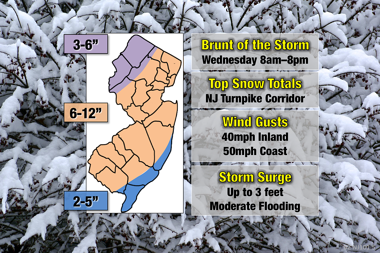
Significant spring snowstorm: 6 to 12 inches for most of NJ
As my beautiful wife just so eloquently reminded me... Winter is over! Spring officially sprang at 12:15 p.m. Tuesday. And now we're in the middle of yet another nor'easter — another significant winter storm that will impact the Garden State through Wednesday night.
So far, Round #1 of this winter storm has played out close to forecast. While there was less of a snow component to Tuesday afternoon's wintry mix than I expected, we experienced only minor impacts. I called it sloppy, but manageable — a bit of slush and mostly wet roads during the evening rush hour.
Even more than before, I'm leaning hard toward a conservative (yet still significant) snow forecast, for several reasons:
1.) Lack of snow accumulation for most of Tuesday demonstrates the sun angle and ground temperature concerns are valid.
2.) Dry air has been a surprise limiting factor, with dew points about 10 degrees below forecast so far.
3.) Earlier start time to "the brunt" of the storm, which means more of it happens during daytime, which means it will be inherently warmer throughout the period of maximum accumulation.
4.) Model math. While I'm trying not to "live or die" by models at this point, snowfall guidance has decreased a bit to fall in line nicely with my estimatations.
5.) Gut. I was actually tempted to decrease totals by an inch or two across the board. But in the end, I think 6-12" is a good fit.
In the end, would tweaking the snowfall forecast by an inch or two affect your perspective of this storm, or how you'll deal with it? Probably not. It's going to be a major snow event for the vast majority of the state.
As I've said over and over, I do not buy into the "potentially historic" 18+ inch snow totals that some are touting. Going by a 6:1 snow ratio, that would require 3 inches of liquid QPF. On top of all the late-season limiting factors. I just don't see it, I just don't buy it.
A Winter Storm Warning goes into effect for all 21 counties of New Jersey Tuesday night, continuing through early Thursday morning. A Coastal Flood Warning is in effect for most of the Jersey Shore for Tuesday night and Wednesday.
Light to moderate snow and wintry mix will continue to spread throughout New Jersey Tuesday night into early Wednesday morning. Slow accumulations will lead to slushy and/or icy road conditions.
The brunt of the storm arrives between 8 a.m. and 8 p.m. on Wednesday. That's when wintry mix changes over to moderate-heavy snow across the Garden State. Will snow pour from the sky all day? Probably not. But travel will be challenging for both the morning and evening commutes.
Fierce wind gusts of 40 mph (inland) and 50 mph (coast) are still expected for Tuesday night and Wednesday too. The combination of super-dense snow and gusty winds will almost certainly cause yet another round of power outages.
Coastal flooding is a major concern as well, as 2 to 3 feet of surge will push water levels into the minor to moderate flooding category for the next four high tide cycles. The highest tides are expected late Wednesday morning and late Wednesday evening. No hyperbole — water levels during this storm are forecast to be among the highest of the year.
Snow tapers off Wednesday evening, with snowflakes ending completely early Thursday morning (8 a.m. at the latest). While sunshine will be limited on Thursday, high temperatures in the mid 40s will kickstart the melt.
As always, be smart and be safe! Next weather blog update expected by 7 a.m. Wednesday.
More From 92.7 WOBM


