First winter storm of 2018: A nail-biter for New Jersey
Snow or no snow? It's a epic battle between a coastal storm system and a giant blob of arctic air.
Happy New Year! Let's kick off 2018 with some good ol' fashioned weather hype, shall we? For a week now, the internet has been buzzing about a midweek storm that could bring snow and other significant impacts to the Garden State.
Or maybe it won't. This coastal storm presents one of those glancing blow, edge-of-your-seat forecasts, where we end up right on the edge of the storm. A definitive forecast may not develop until just a few hours before first flakes — any forecaster who says otherwise (or has any confidence at all) is lying to you.
The forecast is complicated, but the possibilities are simple: Snow, or no snow?
Sure Bets
--Timing: Even though there are dramatic differences among the forecast models regarding the track, intensity, and development of this coastal storm, the timeline seems relatively firm. First flakes as early as Wednesday evening (10 p.m.). Storm substantially wraps up by around Thursday late afternoon (4 p.m.). Lingering snow showers through Friday early morning (1 a.m.).
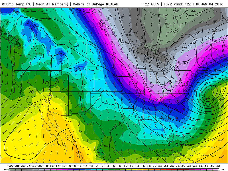
--Cold: I'm sure you've noticed by now that New Jersey is starting the new year with one of the deepest freezes we've seen in a long time. As of this writing, thermometers have been stuck below freezing for a week (since about 6 p.m. Christmas Day), and the chill will continue. Having said that, the target coastal storm will "carry" some warmer air from the south, and we might actually see a few thermometers bump above freezing (mid 30s) on Wednesday-Thursday. But I believe the antecedent cold will negate the chance for any rain or messy mixing. It will be all snow.
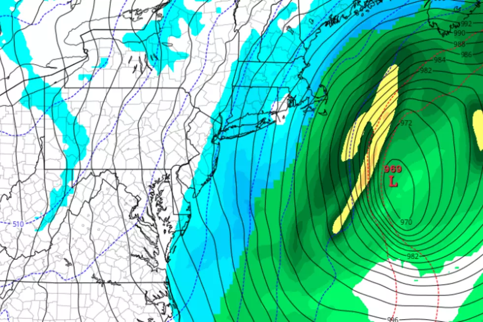
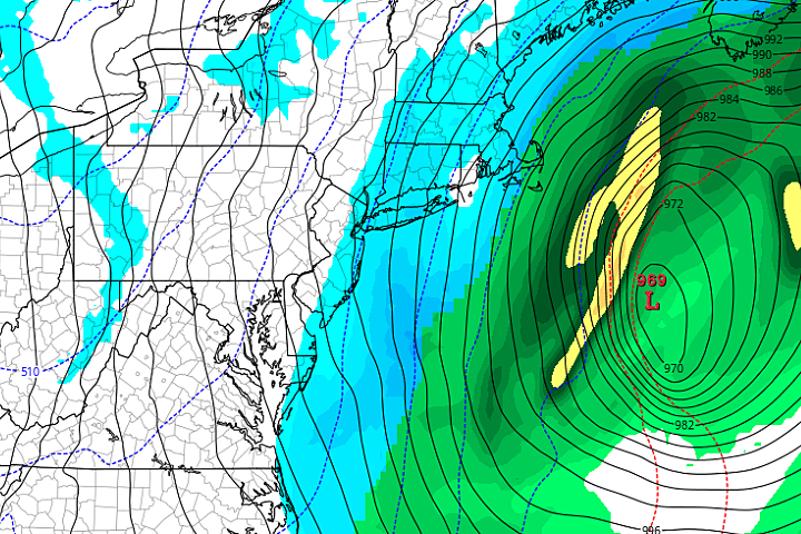
--Wind: This coastal storm is going to develop into a monster low pressure system off the Jersey Shore, with pressures reminiscent of a tropical storm. When strong coastal low meets strong arctic high, the gradient (pressure differences) will almost certainly drive some strong winds — both during and after the storm. So far, I'd estimate gusts in the 40 to 50 mph range. Wind chills behind the storm (on Friday) could be brutal.
--Waves: Any time a storm system passes between the United States and Bermuda, we have to be on the lookout for surge and swell — in other words, the increased risk for beach erosion and coastal flooding. Increased surf is pretty much a definite at this point. The orientation and strength of the storm and its wind field will determine whether we're talking about 4-foot waves or 10-foot waves along the Jersey Shore.
The Big Question Mark: Snow
--Bottom Line? The closer the center of this coastal storm tracks to the U.S. East Coast, the more snow we're going to see. (Duh.) The current model consensus shows a "glancing blow" to New Jersey, with at least a few inches of snow accumulation along the coast and hardly anything further inland. As a coast-hugger, this storm will almost certainly produce the most snow right along the coast: Monmouth, Ocean, Atlantic, and Cape May counties.
--How Much is a Few? The highest raw model output I've seen for this storm: 10 inches in far southeastern New Jersey (according to the latest Euro model run). The lowest snowfall potential: a big zero for far northwestern and southwestern New Jersey. As the NAM (short-range, mesoscale model) has started resolving the storm, it largely keeps the snow away from the Garden State. The GFS and its ensemble is a "middle ground" solution, with about 2-4" along the eastern edge of NJ, and 0-1" to the west.
--Forecast Trend? Models are admittedly trending westward (toward the coast), illustrated by the Euro's idea of kissing NJ's south coast with double-digit totals. But overcoming the huge trough of arctic air gripping most of the United States is going to be a huge challenge. I don't believe it's time to pull the trigger on big numbers just yet. Until (and unless) models converge on the closer, snowier Euro solution, I'm leaning toward the GFS track and totals for now: 3" along the coast, hardly anything along the Delaware River.
--Forecast Confidence? Pretty low, even though we're almost 48 hours away from first flakes. As we've seen many times from coastal storms, there will probably be a tight snowfall gradient (snow vs. no-snow) somewhere near or over New Jersey. Where to draw that line, and how high to push snowfall estimates? Hopefully we'll have better resolution on that in the coming hours and days, and I'll be able to share a snowfall forecast map with you.
That's it for now — we'll have much more to discuss in the coming days. Enjoy the rest of your New Year's Day celebration, and I'll "see" you on the radio bright n' early on the 2nd! Next weather blog update expected by 7 a.m. Tuesday morning.
More From 92.7 WOBM


