
Disruptive winter storm to bring significant snow and rough surf to NJ
In addition to a wide swath of 12+ inch snow totals, gale force winds and tidal flooding will make for a nasty weekend in the Garden State.
Here you go... Our very first stab at a New Jersey snowfall accumulation forecast for this weekend's nor'easter...
Please be gentle. This forecast represents my expert meteorological opinion at the current moment, given all available data and information. I really don't like saying my forecasts are subject to change... Instead, they are subject to evolve - that WILL change - as new information arrives, we adjust the forecast accordingly. Generally, we issue new snowfall forecast maps twice a day, in the early morning and again by late afternoon.
I highly recommend you review my weather blog post from this morning, titled 8 things to know about this weekend's winter storm, for a complete breakdown of the forecast and the potentially severe impacts here in New Jersey. Here are a few additional random points to consider...
--Winter Storm Watch: Right on schedule, the National Weather Service has issued a Winter Storm Watch - which means winter storm conditions are expected within 48 hours. To help you decipher any wintertime advisories that are issued through this weekend, we have posted a comprehensive primer.
--Timing: I'm still not thrilled by the model consensus specifically regarding the timeline of this storm. We're pretty sure at this point that snowflakes will start falling in far South Jersey sometime between 6 p.m. and Midnight on Friday evening. So the vast majority of New Jerseyans will be able to make it home from work and school on Friday without trouble. The GFS alone then pumps out the heaviest snow of the storm during the early morning hours on Saturday, with snow continuing through early Sunday morning. The snow timing according to the European model (among others) is later, pushing out the heaviest snow on Saturday afternoon and evening, with snow finally tapering off in New Jersey by midday Sunday.
--Dry Slot: An injection of dry air, which has shown up in a couple of model solutions so far, would kill the heavy snow forecast. Yes, it would still snow. Yes, it would still snow a lot. But "feet" of snow would be difficult to achieve if it doesn't snow consistently all day Saturday.
--Temperatures: OK, so the raw model output now seems to think the Jersey Shore will stay all-snow through the duration of the storm. But GFS MOS shows a high temperature of 42 degrees on Saturday! I still think there will be some degree of mixing and/or transition to all rain along the warmer coastline on Saturday. That would, of course, dramatically decrease final snow totals (as shown on our forecast map).
--Wiggle Wiggle Wiggle: This forecast is incredibly sensitive to the storm's ultimate track, as the difference between a "boom" (12+ inches) and "bust" (less than 4 inches) snowfall will happen over a pretty short distance. (Frankly, there's a piece of me that wonders if Sussex County will even see an inch of rain!) I'm fairly comfortable with the map I've put out this afternoon, but do not be surprised at all to see all the entire bundle of color contours shift one way or the other as the model forecast continues to get tweaked. I also left room for a "greater than 18 inch" contour if it becomes necessary...
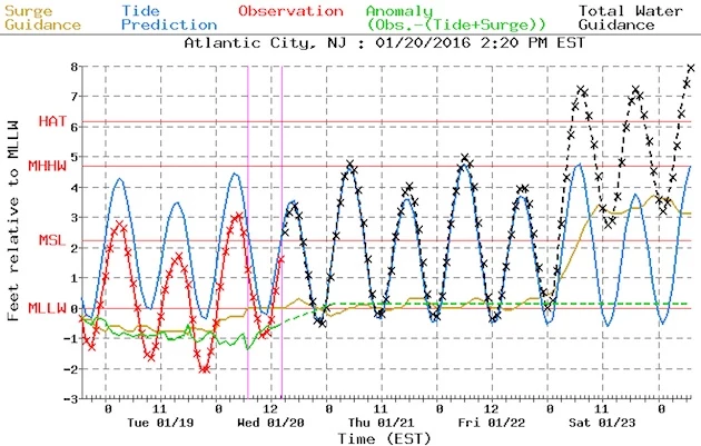
--Surf's Up: The situation along the Jersey Shore continues to scare me quite a bit. As I suggested this morning, if you live near a tidal waterway, take a close look at an upcoming high tide. Then visualize what another 4 to 6 feet of water would look like. That's what is expected to happen on Saturday. 12 to 20 foot waves crashing onto the beach mean erosion is pretty much a sure bet. And the coastal flooding won't nearly be Sandy-esque... However, it will likely be a memorable "top ten" flood of record for many coastal locations. No matter what happens to the snow forecast, coastal impacts are going to be huge.
That's enough for now. Of course, I will continue to monitor the storm's progress and forecast and bring you the latest on-air and online through the weekend!
Next update scheduled for about 7 a.m. Thursday morning.
More From 92.7 WOBM


